

When we think about the use of lidar technology within the commercial drone sector, surveying and mapping comes immediately to mind. There’s good reason for this, as the surveying community overall was among the earliest adopters of lidar, and while applications in autonomous driving have driven the technology forward, surveyors remain near the top of users for the sensors. In fact, in a recent conversation with Trimble Applanix’s Joe Hutton, he noted that they see the largest user base of drone-based lidar being surveyors, specifically for topographic mapping. So there is no doubt that the technology is extremely valuable for these users, and that usage is not slowing down. However, it would be a mistake to think that if you don’t work in that specific field, that lidar is of no use for your applications.
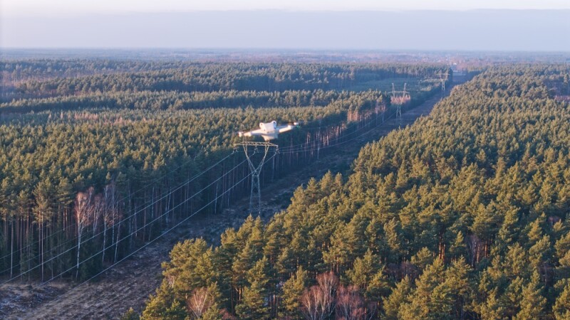
Utility Corridor Inspection
One of the clearest examples of it finding a home outside of traditional surveying is in utility corridor inspection. Power transmission networks stretch across thousands of miles of our landscape, much of it forested, and managing vegetation encroachment along those corridors is a never-ending battle and extremely important, as overgrown trees are among the leading causes of outages and wildfire risk.
Drone-based lidar addresses this problem in a way that photogrammetry generally can't match. Because lidar penetrates the canopy and returns data from multiple surfaces simultaneously, operators can model the full vertical structure of a corridor in a single pass, measuring clearance distances, identifying hazard trees, and flagging sections where growth is approaching threshold limits.
What makes this application particularly compelling is repeatability. When an inspector flies the same route on a regular schedule, it can both flag immediate issues while also tracking changes over time. As BVLOS rulemaking advances, corridor inspection is among the use cases positioned to benefit most from expanded operational authority.
Forestry Inventory
Forestry represents another vertical where lidar's value diverges somewhat from the traditional map-making application. Instead, lidar in this vertical is able to provide structural data such as tree heights, crown dimensions, and stem density across large tracts of land. These are metrics that field crews can spend weeks collecting with traditional means, and that photogrammetry can only approximate where the canopy is dense.
Lidar, meanwhile, solves this by capturing returns from multiple vertical layers simultaneously. A single flight can produce both a bare-earth terrain model and a detailed picture of canopy structure above it, without additional passes or manual filtering. That dual capability is significant for an application like timber inventory, where accurate biomass estimates depend on separating ground elevation from vegetation height reliably.
Stockpile and Volumetric Measurement
Stockpile measurement is one of the more straightforward lidar applications outside of surveying, but it's also one of the most immediately profitable for operators looking to expand their service offerings. Mining operations, aggregate yards, and construction sites all have a recurring need to know how much material they have on hand, and traditional measurement methods are slow, labor-intensive, sometimes unsafe, and often inconsistent.
Drone-based lidar handles this efficiently. Accurate volumetric calculations require a reliable surface model, and lidar produces one regardless of material color, surface texture, or lighting conditions. Photogrammetry can work for stockpile measurement in ideal conditions, but it degrades quickly on uniform surfaces like gravel or coal, where there is little visual contrast for the software to work with.
The business case here is also driven by frequency. A one-time stockpile survey has limited value. But operators who can offer clients a consistent measurement cadence are providing something closer to an inventory management service than a survey deliverable. That recurring relationship is where the long-term value for drone service providers lies.
Surveying and mapping will remain the dominant application for drone-based lidar, and that’s for a very good reason. But the technology's underlying capability – capturing accurate, multi-return 3D data in conditions where other sensors fall short – translates directly to problems that operators in utilities, forestry, and aggregates are actively trying to solve. For drone service providers looking to grow, these verticals offer something valuable: Recurring work tied to operational needs rather than one-time project deliverables. The question is less whether lidar has a place outside of surveying, and more which of these applications aligns with the clients and workflows you already have.


Comments