
We’ve looked at videos which showcase how drones are being used in utilities, agriculture, search & rescue and mining, all of which have demonstrated the versatility of UAVs. In many of these industries, the restrictions around flying beyond visual line-of-sight present challenges for operators, since they’ll usually have vast areas they’ll want to fly over. Construction sites are typically much more limited in scope, making drones the ideal tool to document what is and isn’t happening for various stakeholders.
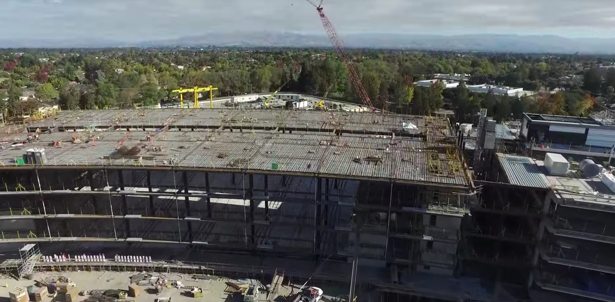
Most of these videos below do a great job of illustrating the info and data that can be captured via a drone, but understanding the specific ways construction professionals use this data aren't always as apparent. To get some specific insight from professionals around how they've been using these tools, check out a recent webinar from Skycatch that details how drones are creating new opportunities within the construction industry, as well as one hosted by sister site SPAR 3D. Additionally, you can learn how industry leaders are implementing UAVs to improve efficiency, production and safety in construction projects via our free download.With one hour of video being uploaded to YouTube every second, we’ve undoubtedly missed out on some great video resources, so please let us know via Twitter or email which videos can and should be included in Part 2.https://www.youtube.com/embed/8e4kcyUR_pwPutting Drones To Work In Construction – Umap TechnologiesWe’re going to be running through a few videos that do a great job of detailing and documenting the footage construction professionals can and would need to capture on a job, but in many cases there will be questions about what comes next. How can and should this data be used?This video by Umap Technologies quickly and concisely lays out how the data captured from a drone can be utilized. It details a 2D bird’s-eye view of worksites that drones can provide which in turn allow operators to compare them to site plans. The video also shows viewers what the 3D perspective of that same site looks like when the appropriate data is captured.What’s here is a great primer for anyone who simply wants to get a grasp on what’s possible with the technology. The video ends up being a pitch for the company’s drone mapping software, but for anyone who’s just getting started, that can be a good place to start a conversation. Autodesk + Skycatch – Skycatch Inc.For professionals who want to go a bit more in-depth around what drones can do on and for a construction site, Autodesk and Skycatch have you covered. I mentioned the recent webinar from Skycatch in the intro, and as viewers can probably tell from that conversation, their focus is around enabling construction professionals in a powerful way.The video above showcases Autodesk integration of Skycatch data, and viewers are able to see all of the possibilities that are presented to and for them. We watch as data that is captured from a drone is pulled into the software where it does things like align Skycatch 3D data with CAD files in Autodesk Recap, but it’s things like the real-time 3D mapping and annotation requests that really illustrate what can be done on a practical level.Anyone just getting started with the technology might feel overwhelmed by what’s here, but novices can get a better grasp around the possibilities, while anyone with some experience can see the specifics of what features they might want to enable or pursue. For more from Skycatch, check out the article Christian Sanz published for us. Augmentation of drone videos for building site monitoring – BEAppliedResearchProfessionals who use 3D scanning technology were among the first to recognize what kind of an opportunity drones presented. After all, if the tools they were using could gather such incredible and intricate detail from a single perspective, how much more could they do when that perspective shifted into the air?That was something Bentley Systems recognized, and they’ve moved forward with several initiatives to give professionals much more powerful tools, and that includes their work with AR (augmented reality). The video shows the results of that work which was aimed at evaluating the potential of using drones for building site monitoring.The video shows the original footage of a building, but then provides viewers with a look at it after it’s been augmented with ContextCapture mesh, wireframe BIM model and with a future top floor model. It’s a great look at how drones and the data they capture can help construction professionals document the specifics of a project. If you’re interested, SPAR 3D editor Sean Higgins has laid out plenty more detail about this topic. How are drone's helping the construction industry? – Identified TechnologiesI’ve mentioned how the webinars listed above provide insight around the specific ways professionals are using drones, which is very different than the videos that detail specific capabilities of the hardware and software. That breakout means it can be difficult to have an understanding of how these two things tie together. Luckily, the video from Identified Technologies combines these two subject matters together in a very concise manner.At first, the video details the major features of drones, like the ability to access and share data in near real-time. We also get to see things like a point cloud with centime precision, a georeferenced orthomosaic, and 3D volumetric analysis. However, it is the info that Jon Machen, a project manager with Mascaro Construction, talks through that makes the video worth watching.Machen spends his time on camera detailing how drones have impacted the way he works. He mentions the reports back on progress to stakeholders that he has to imitate as being especially valuable, but also explains how and why such things have safety implications. In a few instances it feels like he’s being cut off, and it would have been great to get even more from him, as his experience is both genuine and impressive. Apple Campus 2 November 2015 Construction Update in 4K – Duncan SinfieldMost times you save the best for last, but in this case I’m saving the most obvious for last. Over 400,000 people have viewed this video of the in-progress construction of the new Apple Headquarters, and clearly the brand as well as the design of the building itself have compelled a lot of people to take an interest in this.Such things shouldn’t get in the way of the fact that the video gives us an amazing look at a project as it’s being put together. Viewers are able to see where work is and isn’t being done, and it’s easy to see how someone would be able to quickly and easily track what’s going on at this site by visuals alone, much less from the more detailed data that the UAV could be gathering.What’s great is that because there’s such an interest in this building, you can easily take a look at the progress of the construction. More recent videos are available, and there’s no doubt they’ll continue to be filmed and posted. It’s proof that the info a company can gather via drones can be both a valuable tool for project managers as well as a powerful promotional tool.Subscribe
The information you submit will be stored and used to communicate with you about your interest in Commercial UAV News. To understand more about how we use and store information, please refer to our privacy policy.

Want more stories like this? Subscribe today!
.jpg.small.400x400.jpg)


Jeremiah Karpowicz is the former Editorial Director of Commercial UAV News. He has spent over a decade cultivating communities of all different types, both in-person and online. He has created articles, videos, newsletters, ebooks and plenty more for these communities as a contributor and editor. He has also shaped and defined various conference programs. Today, he is focused on defining what it means to take the engagement that happens in both the physical and digital worlds to the next level. You can get in touch with him on LinkedIn.
Featured Report
Featured Authors More Authors ›

Featured Authors


Newsletter Signup
Our Events


Our Events
September 1-3, 2026 • Las Vegas
February 23-25, 2027 • Salt Lake City
Comments