
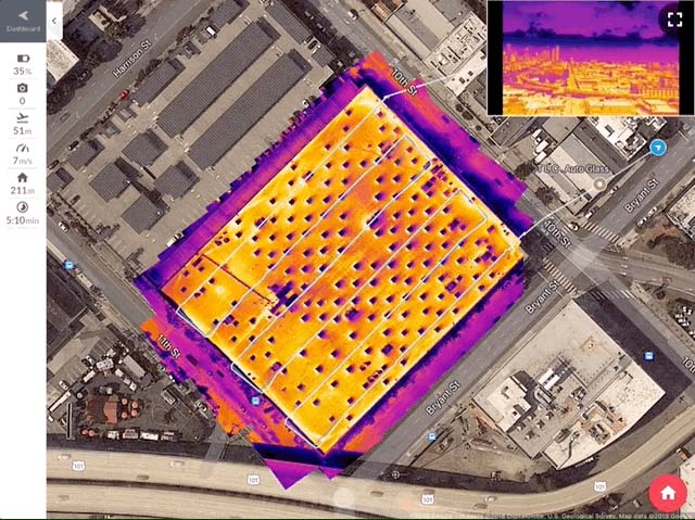
Numerous products and updates were announced at Commercial UAV Expo 2018, but one that was released earlier this year caught our eye. Thermal Live Map from DroneDeploy visualizes temperature variability to create thermal maps as the drone flies, and that allows users to make real-time decisions on their site. Users can instantly see the unseeable, without a computer, SD card, or even an internet connection.
At Commercial UAV Expo 2018, Jay Mulakala from DroneDeploy took the time to connect with us to highlight how users have been able to take advantage of these thermal capabilities, how easy it is to utilize them and plenty more.&feature=youtu.beSubscribe
The information you submit will be stored and used to communicate with you about your interest in Commercial UAV News. To understand more about how we use and store information, please refer to our privacy policy.
October 9, 2018
The Advantages of Thermal Live Map from DroneDeploy - Commercial UAV Expo 2018

Want more stories like this? Subscribe today!


Jeremiah Karpowicz is the former Editorial Director of Commercial UAV News. He has spent over a decade cultivating communities of all different types, both in-person and online. He has created articles, videos, newsletters, ebooks and plenty more for these communities as a contributor and editor. He has also shaped and defined various conference programs. Today, he is focused on defining what it means to take the engagement that happens in both the physical and digital worlds to the next level. You can get in touch with him on LinkedIn.
Featured Report
Featured Authors More Authors ›

Featured Authors


Newsletter Signup
Our Events


Our Events
September 1-3, 2026 • Las Vegas
February 23-25, 2027 • Salt Lake City
Comments