

The many ways in which drones can impact how construction professionals might approach a project have been well documented, but recent changes to regulation and advances of UAV technology have altered these conversations. Rather than focusing on the potential of these tools, many stakeholders are ready to explore where and how UAVs can make a difference. How will a drone impact their bottom line? Will it mean training for the current crew? What kind of data will they be getting from a drone?
Beyond such practicalities, questions around what adoption looks like for organizations of different scales and scope remain. After all, it’s one thing to figure out the best way to utilize a drone on a specific project, but it’s quite another to work through what doing so will mean across an entire organization.
Recently, the team at 3DR connected with experts from large and small firms to detail exactly how drones were making a difference for them. Whether it was the 4X increase in productivity with Site Scan or how a company is using drones as a QA/QC Tool, it’s clear these practical differences are being realized, and it’s especially notable to see how companies of various sizes are seeing those distinctions. By making it easy to collect and process aerial data while seamlessly integrating with existing workflows, drones are increasingly finding a place on jobsites of any size.
Seeing the Same Differences
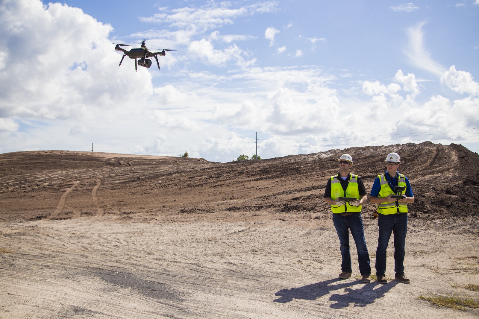
Two very different companies have showcased how and where drones are making a difference for them. Bogh Engineering is a 3rd generation family owned construction and engineering company with 65 employees. On the other end of the spectrum, PCL Construction is a group of independent general contracting construction companies with over 4,400 employees across the United States, Canada and Australia. Both companies have been able to identify the difference UAV technology has made to their bottom line and the way they approach a project.
Bill Bennington is Virtual Construction Manager at PCL Construction Services, Inc. He’s been an active part of the company’s project startup process, which includes a discussion between project teams and district management, to determine which tools and technologies could be leveraged to add value to the project. These talks are focused on how technology like drones can impact a specific project, but these are conversations that have implications for the entire organization.
“I think our size made it easier to move forward with the technology,” Bennington said. “At any given time, we have many projects underway in various market sectors and phases of construction. This allowed us to quickly put the system in use and test its full range of capabilities.”
Bennington can and does consider the differences the technology represents for projects that vary in scope and scale, but the differences he’s looking for are the same as the ones for professionals who are focused on single projects.
Mark Bogh is the President of Bogh Engineering, and he’s actively involved with the demolition and rebuild of Indio High School in Indio, CA. His company flies their drone everyday on their current export job to look at areas that need to be cut or shaved, as well as areas that need to be filled. He’s able to use the data gathered by the drone to ensure he’s being as strategic as possible in that process, as not doing so generates unnecessary expenses for the 40 acre site. However, he’s been able to leverage the drone in a far more specific and even beneficial manner.
“The reason I bought the drone is because the way that my work is scheduled,” Bogh mentioned. “When we're not doing grading, we're primarily the concrete contractor. If the grade isn't right, or if the grade was right and then got disturbed, I'm the one that often has to pay to fix it. With the drone, I can look at a particular spot and see the grade is messed up. It allows me to identify where and how that grade got messed up, which means it’s that person’s responsibility to fix it.”
When that doesn’t happen, it’s an issue that Bogh has had to pay for in more ways than one, whether it’s a direct expense or an argument with contractors or even the client. Avoiding these kinds of issues can make or break a project, but how are they best quantified when looking at the bottom line?
Quantifying an ROI
Many construction professionals understand what it can mean to spot an issue before it turns into a problem. Professionals recognize the time and expense correcting a problem represents, but how can that time and expense be calculated when it never occurs? That’s the dilemma for many professionals, as drones allow them to spot and avoid these unnecessary problems that are a reality on all construction projects. That being the case, where and how can construction professionals quantify the difference they’re able to see when using a drone?
“This question is often asked and difficult to answer,” Bennington explained. “How do you quantify the value of a quality issue that never happened because it was prevented through our use of a drone? How do you determine the value of showcasing your drone capabilities to a potential client? However, we are tracking the time and resources spent utilizing the drone to determine grades and contours vs the cost of traditional survey. We’ve also looked at the cost savings associated with foregoing traditional aerial photography.”
One of the best explanations around where and how users can find this kind of value relates to drones being able to do something faster, cheaper or safer. Users might not be able to see these distinctions in every single task a drone performs, but those differences are evident across an entire project. However, being able to properly quantify the value of a drone means being able to use the tool in a way that makes sense logistically and financially.
“You can't use the drone like you'd use a survey crew for exacting work,” said Bogh. “They can get you close though, and that can work really well. We just flew it the other day and within an hour my guy emailed me with a cut/fill map. Just like that, off we go. I was literally just looking at that map, trying to figure out what to do tomorrow. It allows me to be responsive to the job in an incredibly powerful way.”
That kind of responsiveness might be difficult to quantify, but it’s a distinction that’s just as real as it is important. Mistakes can be the difference between a project running over budget and coming under budget, and drones can represent the difference between being on one side of the ledger or the other.
Sorting Through the Data
While most professionals talk about how drones can and are just another tool, the sense that UAVs are an inherently different piece of technology still persists. It’s often the cause of challenges when it comes to transitioning the data gathered by a drone into a user’s ecosystem, since many view this data as something inherently foreign. However, the data gathered by a drone is not vastly different from the kind of data that any professional should be familiar with.
“My AutoCAD, my Civil 3D, and my computers at the office are there to handle this data whether I fly a drone or whether I have a survey crew,” said Bogh. “It's not apples and oranges. It's not a foreign concept. The aerial mapping has been done since the 50's. It was just done manually. If you're used to topograhic surveys and digital terrain models, this is just a different way to collect the data. It's the same process.”
Challenges relating to how data can and should be integrated into an ecosystem can stem from issues related to that much more data being gathered, or from an uncertainty around the process itself. That’s why it’s essential to break down this process and determine the approach that can and should be taken for each step.
“You need to think of the system in two parts,” Bennington explained. “You have the collection of data in the field and the consumption of the data in the office. The collection part can easily be performed by our existing field personnel. We have four operations staff in the Orlando office who have passed the Part 107 exam and received their certification to fly sUAS. Each of the four individuals have self-studied using the information provided by 3DR. Once the data is collected and processed via Site Scan, the outputs are in file formats that work with our native BIM (Building Information Modeling) programs and processes in the office.”
Of course, being able to sort and transmit data to where it needs to go in a given ecosystem for a specific project isn’t going to be an automatic process, and it’s one that project stakeholders need to actively consider. However, that same process is one that would need to be dealt with regardless of what tool was being used. It makes the effort to do so for data gathered by a drone more similar than different when compared to more familiar tools.
Taking to the Sky
Changes in regulation and advances to drone technology itself have made it easier than ever for commercial operators to take to the sky. Field engineers have detailed what it meant for them to become FAA remote pilots, while features like the Site Scan Field mobile application allows any user to plan an autonomous flight. The practical implications of doing so are incredibly important considerations for construction professionals.
“The actual drone piece was pretty simple,” Bogh said. “Within about four weeks we had a kid hired and he had taken the test. The more challenging thing was learning the intricacies of how to fold the information into our existing workflows. It took maybe five weeks to get working.”
Once that process is up and running, stakeholders can see the differences drones represent in multiple ways. PCL identified their need to do frequent grading with a cost-effective, scalable solution, and drones have proven to be an effective solution because they know what they want and need from the data.
“We are actively meeting with our repeat clients and discussing the benefits of drones and explaining how we are using the data we capture; beyond just ‘pretty pictures’”, said Bennington. “The photos actually represent a small portion of the usable data output we generate; the real benefit is in the 3D point clouds and meshes.”
Professionals at large organizations like PCL Construction and smaller firms like Bogh Engineering have been able to use drones to adjust the time on cut-and-fill tasks from 2 days to ½ a day as well as reduce the time a surveyor would need from a week to a day and a half. Organizations of any size can see similar results, but doing so depends on a conscious effort to leverage and utilize these tools in a way that makes sense for a given project or organization. Fortunately, the benefits of doing so are both measurable and practical.


Comments