

Contributed by Paul Harty, Director of Sky Scan Surveys
When a disaster happens or a large construction project finishes, clearing the site can be a big logistical challenge. Traditional methods usually involve teams walking the site, taking notes, and making rough estimates of what needs to be done. These approaches are time-consuming and can put staff at risk in hazardous areas. Aerial mapping is changing the way organizations manage large-scale site clean-up by providing quicker, more accurate data to support better decision-making.
Faster Safer Assessments
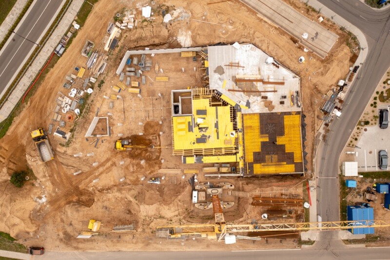
Drones with high-resolution cameras and lidar sensors let teams capture a whole site quickly from different angles. This top-down view helps project managers see the full amount of debris, damage, or waste without putting staff in dangerous areas. For example, industrial sites, construction zones, or post-disaster locations can be surveyed much faster than using traditional methods.
A key benefit is being able to watch the site all the time. Drones can fly the same paths every day or week, noting any changes and keeping a record of progress. This is very useful in disaster response, where conditions can change quickly and teams need up-to-date information to plan and adjust clean-up work.
Precise Measurements and Data
Aerial mapping provides more than visuals; it generates precise measurements of volume, area, and topography. This data is essential for planning how much equipment, staff, and time will be required for clean-up. Software tools can convert aerial images into 3D models, making it easier to identify hotspots that need immediate attention or areas where resources can be used more efficiently.
For example, calculating the volume of debris piles from drone imagery can prevent underestimating the number of trucks or containers required for removal. It also helps to determine whether specialized machinery, such as excavators or cranes, is needed before teams arrive on site. This kind of data-driven planning reduces delays and ensures resources are used effectively.
Using Reliable Data Sources
Working with experienced aerial mapping providers ensures that clean-up projects are carried out efficiently and safely. Using resources like Sky Scan Surveys for accurate drone survey data helps teams plan and allocate resources without unnecessary delays or risks. These surveys provide detailed maps that capture terrain, infrastructure, and potential hazards in a format that is easy to share and analyze.
Improved Communication and Planning
Sharing aerial data with stakeholders, from contractors to environmental agencies, is straightforward. Digital maps and 3D models can be annotated and shared instantly, ensuring everyone has the same understanding of the site. This reduces miscommunication, prevents delays, and improves overall project efficiency. For more examples of aerial mapping applications in the industry, see Commercial UAV News’ article on site monitoring with drones.
These maps also support cross-team collaboration. Environmental specialists, engineers, and logistics teams can all use the same data, which reduces the need for repeated site visits. In emergency situations, this can save hours and even lives, as teams can coordinate remotely while still making accurate decisions.
Cost Savings and Environmental Benefits
Reducing the need for extensive on-site surveys and minimizing wasted resources leads to significant cost savings. Aerial mapping also supports environmentally responsible clean-up by helping teams plan routes and methods that reduce soil disturbance, prevent unnecessary vehicle movements, and lower fuel consumption.
By analyzing aerial imagery, teams can identify areas where debris or contamination could affect natural habitats and adjust clean-up methods accordingly. Companies can also use tools like DroneDeploy’s site management guides to learn more about planning and integrating data for large sites. This information helps make clean-ups more efficient while reducing environmental impact.
Future Applications and Technology Integration
Aerial mapping is now often combined with technologies like AI, machine learning, and real-time analytics. AI can quickly spot hazards, recognize different types of debris, and suggest the best clean-up methods based on past data. When combined with aerial mapping, these tools can turn a large, complex site into useful insights in just a few hours instead of days.
Organizations that adopt these technologies early can respond faster to emergencies, reduce operational costs, and maintain higher safety standards. For large infrastructure projects, this capability also ensures regulatory compliance while keeping stakeholders informed.
Conclusion
Aerial mapping is proving to be an important tool for managing large-scale site clean-ups. It gives teams fast, accurate, and useful information, helping them save time, reduce risks, and make better decisions. As technology advances, aerial mapping will be key to carrying out site work safely, efficiently, and with minimal environmental impact.
About the Author
Paul H. is the Director of Sky Scan Surveys, Greater Manchester’s leading drone surveying specialist. With over a decade of experience in construction and surveying, Paul has pioneered the integration of advanced drone technology into topographical mapping, 3D modeling, and precision line drafting. Prior to founding Sky Scan Surveys, he worked extensively on Network Rail Infrastructure in safety-critical roles, gaining invaluable expertise in project logistics and safety protocols. Today, he leads a team of CAA-certified drone pilots, delivering innovative aerial data solutions that help businesses save time, improve efficiency, and make smarter decisions.


Comments