The drone market environment is a large one, and the commercial platform manufacturer segment will undoubtedly shift and change as ramifications of Part 107 continue to play out. Recent news from the U.S. Department of the Interior got me thinking about how 3D Robotics (3DR) is looking to approach these kinds of developments, especially in light of the changes they’ve already gone through.

Daniel McKinnon
Daniel McKinnon, Director of Product at 3DR, was kind enough to further explore all of those things and more during an in-depth interview. We discussed 3DR’s refocus on the commercial market, how that refocus impacted the company internally, what kind of opportunities users have with Site Scan and plenty more.
Jeremiah Karpowicz: Before we get into what I really want to ask you about, I thought we could at least to touch on the recent news out of the U.S. Department of the Interior, as they’ve awarded a contract to 3DR. What can you tell us about the lengthy process to develop performance requirements and select the most useful type of aircraft they referenced in the release?Daniel McKinnon: Thanks for asking. We are thrilled that the Department of Interior has selected Site Scan as an sUAS platform. The selection process was rigorous, but straightforward. The DOI simply wanted to invest in the unmanned system that best balanced ease-of-use, reliability, and simplicity. They were looking for a complete package that combined the hardware, software, and support they needed to be successful with their unmanned program. After a demo at the field office in Boise, ID, it was clear that the features offered by Site Scan nearly exactly matched the needs of the DOI, including, wildlife and vegetation surveys, fire management, search and rescue, hydrologic study, cultural resource inventory, and surface mining monitoring.
Are developments like these more relevant to other government agencies or to commercial users in terms of what this will showcase about how the technology can be utilized?While the use-cases listed above are fairly unique to the DOI, most of them involve analyzing the high-resolution orthomosaic images and point clouds, which are automatically generated by Site Scan. These data products are also extensively used in the commercial markets for construction, mining, and survey, so fortunately there is significant overlap in the technology needed to deliver solutions to both commercial and government customers.
This announcement seems like it lines up very well with the refocus on the corporate market that 3DR initiated earlier this year. Would this development have been possible without that refocus?At 3DR, we have a long history of selling products into the commercial markets, specifically in mapping drones. We partnered with Pix4D to deliver Aero-M and X8-M several years ago and have seen many commercial drone manufacturers adopt our autopilot and flight stack. Refocusing on the commercial market has allowed us to allocate more resources toward building delightful features for these users, but that refocus alone was not responsible for landing this contract.
What kind of opportunities has that refocus opened up for 3DR?
Sony R10 C comparison graphic
Refocusing on the commercial market has freed significant resources to build a whole slew of exciting features coming down the pipeline. Most immediately, starting 09/01, Site Scan
began shipping with Sony R10C, the highest quality camera available on a commercial drone today.
A super high-quality camera dramatically increases the accuracy of the orthomosaics and point clouds generated by Site Scan or any UAV solution. While hobby-grade cameras are excellent for marketing updates, client presentation, and other less quantitative work, data products generated by the R10C get down to several centimeter resolution across a large site when good ground control practices are employed. This type of hardware opens up the survey and construction market in a way not possible with a lower quality solution.
I have to admit, I didn’t see how that new focus for 3DR lined up with the announcement that came out a few weeks later when we heard about the creation of the Drone Manufacturers Alliance. Based on some initial comments, If felt like that organization was going to focus on drones used in the recreational space, but that’s not really what the DMA is about, is it?These divisions were largely driven by BVLOS vs. VLOS operation, rather than recreational vs. commercial. The Googles and Amazons of the world are lobbying for quite different regulatory environment than the 3DRs and DJIs.
We’ve already seen other ramifications of that shift, as a recent article in UAS Magazine focused on what it’s meant for the company and for your customers. Internally, what did you talk about with your team in terms of how you were going to specifically focus on the needs of construction and survey professionals? My team has been working on commercial drones for nearly two years, but it was actually quite an easy conversation to have with the company as a whole. We have a strong partnership with Autodesk, the leading provider of software to these industries, construction and survey professionals were using our product before we even explicitly began marketing to them, and reality capture is tremendously interesting from a technical perspective.
A good chunk of this time was spent building the Site Scan Field mobile app, the Site Scan Manager web app, and the deep integration with the Autodesk cloud and ReCap engine. That said, we also did release
a commercial product that is still sold through AGCO dealerships and have been selling Pixhawk autopilots to commercial users like UAV Solutions, Falcon Unmanned, and essentially every other commercial drone manufacturers aside from DJI and Sensefly.
 Was your focus more on bringing the actual hardware and software you had utilized in the recreational space to the commercial space, or about bringing over relevant lessons learned?
Our flight code, mission planning algorithms, and various pieces of firmware were all reused. It is quite powerful for us to sell a product that has been flying for nearly 10 years and running on three quarters of a million vehicles.
With more than 750,000 UAS flying the 3DR software stack, we were absolutely able to leverage our DIY and consumer roots into a rock-solid enterprise product.

Sony R10C
Site Scan represents the only complete commercial drone solution on the market. We offer best-in-class hardware, including integration with the Sony R10C camera; flight planning and content management software, including integration with the Autodesk design and planning suit; and a team of support engineers available to our customers to ensure their success. This complete solution is appealing for customers whether they are making their first UAS purchase or whether they have been flying for years. Once a drone becomes a tool and not a toy, the user does not want to burden herself with cobbling together individual components, but rather a single package she can trust.
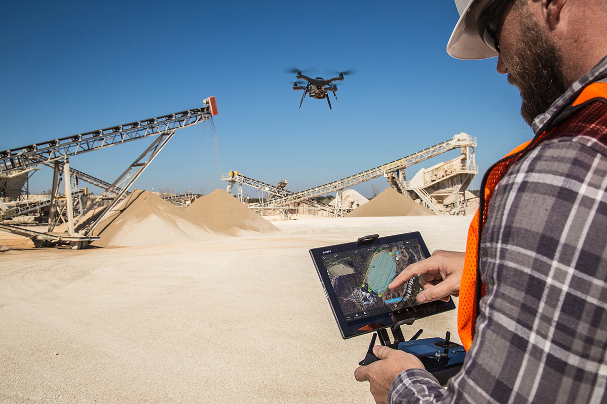
What kind of feedback have you gotten from enterprise users in terms of how they’re effectively using their drone despite not having any familiarity with the technology previously? Are they seeing it impact their bottom line, or is the impact more about an adjustment in process and approach?Our Success Services team supports customers from the day they open the Site Scan package through their first mission and even beyond to analyzing the data using AutoCAD or Revit. This dramatically flattens the learning curve and has helped early customers see success much earlier than they would have otherwise. Even this early, we absolutely have heard customers report positive impacts to their bottom lines. An aggregates plant now flies Site Scan instead of performing manual surveys for volumetrics, a survey firm now flies Site Scan instead of hiking across hilly terrain, and many more.
Leave aside legal considerations, which should be simpler to sort through under Part 107, how difficult would you say it is for an organization that has never used a drone to get up and running?These days it is extremely easy. The Site Scan Field mobile application allows any user to plan an autonomous flight and the Site Scan Manager web application allows any user to manage and process data. The largest challenge in implementing a drone program is integrating the orthomosaic and point cloud data into existing workflows. For some customers, this is totally natural, but we are working hard on reducing the time and complexity separating the flight from the generation of actionable information.
While flying a drone and capturing data is quite easy now, the challenge lies in deriving insight from the data. To get the most out of a UAV investment, preparing a plan for data analytics and management is paramount. Fortunately for Site Scan customers, they have access to 3DR Success Services to walk them through each step along the way.


Comments