

The advantages that drones create for professionals in a construction environment are details that we’ve discussed before, as those capabilities are creating countless opportunities in terms of making a positive impact on the bottom line and keeping everyone safer. When utilized in the right way, UAVs lead to approaches that are both safer and faster, while still gathering the same or even more detailed information when compared to traditional methodologies.
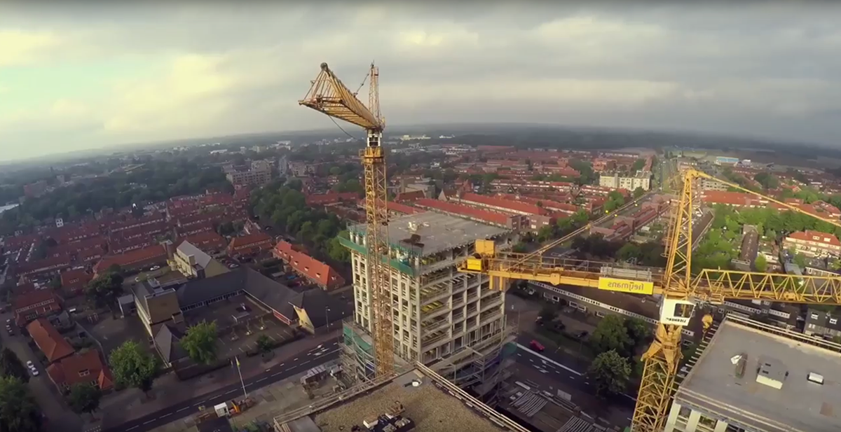
It’s the logistics of the process around drone implementation that can cause troubles for professionals, many of which are related to the information that is being captured by drones and other devices. Drowning in data is a serious issue, as there are questions around how, when and where this information can be leveraged on a current project in addition to how it can be archived and stored for future purposes.It’s a crucial issue to explain and explore, because new techniques are providing additional opportunities that will allow professionals to further leverage this information. Some of those are related to automation and machine learning, as users can tag and then search photos, videos and other assets as they’re captured in the field. How will this elevate the power and value of visual data? An Explosion of ContentSmartvid.io is a software company with a product that's built for the needs of professionals in architecture, engineering, and construction to manage photo and video assets coming from any device, such as mobile phones, drones, wearables, or even things like laser scanners. However, having so many options has created both countless opportunities as well as numerous logistical concerns.“One of the things we've seen in the AEC industry is an explosion of content,” said Josh Kanner, CEO of Smartvid.io. “It's very challenging for businesses and enterprises to not just find what they need but to be able to also manage and share it in a professional manner. So we built the Smartvid.io platform to enable all of those things. Think of it as management, collaboration, and analytics of the content.”Building out a drone program is one of the scenarios the company was started around. Organizations are starting to collect more and more drone data, but there were some very basic questions that weren’t being asked or answered. At a very basic level, how are organizations managing photo content? How are they planning to organize and arrange video content?As the Regional Director of VDC at Skanska USA, those were questions and issues that Oliver Smith knew he’d need to work through in order for a program at his company to be a success. Since Skanska is one of the world's leading construction groups, he knew he’d need to address those questions in detail before he’d be able to move forward with any type of program.“We saw the creation of a drone program as an opportunity” Smith mentioned. “It was always something we were interested in, but we weren't sure how UAVs fit into our overall operations. We saw that the lowest hanging fruit was photo or video status updates that would easily convey things like project progress. We started to evolve our thinking in that way to apply the use of the photo data on all of our job sites.”With the creation of a drone program, Smith saw an opportunity to not only engage their projects and clients and provide progress photos, but as they started to develop a more robust R&D program with it, they recognized more opportunities with safety and security on their job sites. There were opportunities with their quality assurance and quality control process as well, whether it was looking to use drones for inspection processes in order to more quickly gather the necessary info, or to use a drone in place of a person in order to avoid sending that person into a dangerous situation.Doing so has meant an explosion of content in terms of the information and assets they’re capturing all the time, and determining how to handle all of this data is almost a project in and of itself. Storing, managing and sorting through all of that information quickly became an issue for Smith and his team, as they found it difficult to deal with seemingly endless video and photos and pull up exactly what was needed. That’s where a tool like Smartvid.io can and does make such a big difference. Drones and Data “Any new piece of technology is usually going to be most impactful at the beginning,” Smith said. “Evolving it beyond that is something you see with any type of technology. The question is how we evolve it or make it into a better product or deliverable.”The embrace of these sorts of new technology is what’s helped Skanska stay on the cutting edge of the industry. Reducing the amount of time someone needs to spend on a ladder is a benefit that’s felt in small and large ways, but such reality is just the beginning of what it means to use these tools.It’s no stretch to say that drones have gotten industry veterans excited in a way few tools have ever done. With so many different hardware options that feature different capability levels, it’s no wonder that professionals have been anxious to take to the sky. However, doing so can be the least important part of the entire process.“It's not just about the hardware,” Kanner explained. “It's about the data. The question is how can you enable your teams to be able to experiment with multiple kinds of hardware and still have a place at an enterprise level to be able to gather and manage and collaborate on the data. So we see ourselves as being that place.”Experimentation is critical for any organization, but just as a company needs to experiment with how they’re going to collect, analyze, archive and store that data, they also need to ensure that experimentation doesn’t become a way of life. Standardizing that process is a critical component of this process, and it’s one that Kanner has focused on exclusively with Smartvid.io.Without standards in place information can get siloed, which means critical pieces of data will be lost on a tucked away thumb drive or computer. Establishing a process is the only way to manage risk and leverage that data, but taking part in this activity has and will lead to bigger things.
  Organizing Field DataMuch of the focus for the industry as a whole has been on high-level analytics for drone data. That's everything from volumetric analytics to model creation, but professionals also need a set of tools to help with things like quality control and ongoing progress tracking. These tools require interaction not just with photos, but with video. An intelligent approach around that sort of interaction and optimization has opened up new possibilities for machine learning that allows these assets to be integrated into an ongoing project or workflow.“One of the things that sets us apart is that we enable drone pilots to upload an entire 20 minute video of their drone flight and then use a whole set of tools for collaborating and annotating that info,” Kanner said. “Users can even narrate their drone flight, using voice analysis to tease out critical tags or points in the video which you might want to refer other people to.”These types of features open up new and critical means of collaboration and sharing so that someone might only see the tagged portion of the video and not the whole thing to draw their attention to a certain progress update. It ties into the emphasis on intelligently managing photo and video data in order to more efficiently approach inspections and progress tracking, which is something Skanska has already leveraged.“The video option and speech recognition are great tools that our team has been testing,” Smith said. “It’s allowed us to easily handle simple things like knowing what weather conditions are, who the pilot in command is, etc. All of that is information in a video that can then be quickly pulled up for any type of claims or reference.”Simple things like calling out structural elements as they come into view in a video allows users to easily come back and identify such details as needed. All of that info is then searchable and comparable across flights. Making a Difference Today and TomorrowThe differences the optimization of field data can make today are evident with capabilities that allow users to easily access and share info that previously might have been siloed or inaccessible. However, what’s especially exciting to recognize is how this type of information will enable new techniques in machine learning to help tag and search through the ever increasing amounts of videos and photos that are coming from a project.“Some uses of the machine learning that we're starting to see are on the image recognition side of things,” Kanner explained. “We have the capability to be able to do things like automatically count objects. Say you’re able to take an aerial view of a work area. We can take that image and then do things like automatically count the number of trucks or count solar panels that might be in place. It gives you a whole different level of quantitative data from the drone.”Operators of all types and sizes are focused on understanding what they can do to help drive a consistent data management approach across their job sites, and asset management tools that allow them to tag and organize data is a critical aspect of that process. Doing so gives users some options and opportunity to think outside the box when trying to capture, sort and store their data today, but it’s just the beginning. As more high definition data is gathered in photo and imagery is combined with the ability to do an automated analysis, machine learning gets especially powerful. Things like the automatic detection of cracks and leaks with spectral data can be enabled. The more data that’s gathered, the more it can open up possibilities for better defect identification and analysis.Many of those capabilities are in the future, but it’s important to recognize the tools and techniques that will eventually get us there, because many of them are available right now. Most experts agree that drones can and should be thought of as just another tool on a project, but it’s an understanding that needs to be actively considered for anyone looking to integrate UAVs.“In terms of understanding use and benefits, that's always something that's a struggle with any new piece of technology from Day 1,” Smith concluded. “The best approach around implementation is going to be to aim for the smaller, accomplishable deliverables. Progress photos and video for status updates are a great example of that. You want to see the biggest impact in the shortest amount of time, and those sorts of progress updates can be quickly implemented and provide direct, positive impact.”That impact is something Kanner and Smith will continue to explore on different sides of what it means to utilize a drone. Rest assured, it’s a topic that is already making an impact for both which will only increase as these systems and processes become more mature and powerful. To learn more about this topic, see Josh Kanner and Oliver Smith present New Age “Reality Capture”: leveraging machine-learning and BIM to organize field data during the Precision Agriculture track at the upcoming Commercial UAV Expo.


Comments