

The idea of performing high-grade surveying tasks with drones is a tempting one. Marketing materials often promise that with the right drone and the right software, anyone can achieve professional results. Just buy the package, press a button, and watch high-value deliverables appear. But the reality of real-world surveying is much more complicated. In a well-attended session at Commercial UAV Expo, a group of experienced practitioners shared a more grounded perspective: it just isn’t that easy.
Presenters Drew Thacker (DFW ASTM PROS), Robert Young (Trans Texas Surveying and Mapping), Anthony Herman (ASN Constructors), Raymond Akol (Phoenix LiDAR Systems), and Eben Broadbent (University of Florida) offered candid insights into the challenges of merging datasets, operating in harsh conditions, and managing projects that push drone technology - sometimes far beyond the manufacturer’s recommendations. Their stories revealed not just what drones can do, but what it really takes to make them work in demanding survey environments.
Thermography + AI + Lidar = Profit?
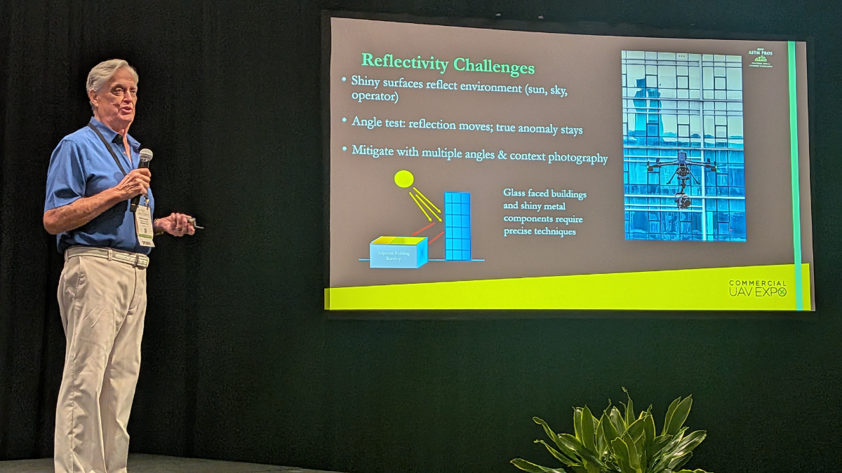
Thacker opened the session with a pitch for a new opportunity for drone pilots - combining thermography, imaging, and lidar together to create quantitative and actionable results. Drone-based data collection is a natural match for rooftop environments, but careful planning of flight paths, correcting for thermal anomalies like shadows and reflections, and other considerations make it challenging, but rewarding. By combining lidar thermography and AI-driven analysis of drone-based data collection, Thacker’s company is able to provide services that are more desired (and pay better) than just taking images or thermography alone.
By combining datasets and providing a more quantifiable output, more value can be gained. When components are imaged and there are temperatures measured quantitatively, those readings can be compared to standards of operating temperatures for components, and that’s something that’s repeatable, clear, and can stand up in court or in legal documentation.
Thacker emphasized that there’s a lot of opportunity in the examples that he shared - from roof and building inspections to solar installations and pipelines.
“Mirroring together all these sensors is really a key to making some serious money in this business, as well as providing clients a true value path.”
Trial, Error and Exploration
In August of 2024, the team at Tran Texas Surveying conducted an ALTA boundary survey to determine the utility of combining aerial and terrestrial lidar with point cloud data. They also wanted to assess the potential of TopoDot and Carlson Point Clouds software for automatic or manual extraction. The results of this work allowed them to identify the best use of lidar sensors for their future projects.
In Young’s presentation, software and drone platforms were compared, and the complexities and realities of the current software/platform landscape was discussed. Nearly a dozen software tools were also mentioned, from Blue Marble, Topodot to Carlson, among others.
“Who out there is using a software that can do it all?” Young asked the audience. No one raised their hands.
The main focus of the talk was comparing captures using DJI and RIEGL- each had their strengths and weaknesses, according to Young. DJI’s drone was far more maneuverable than the fixed wing they were using which feels “a little like driving a semi truck” to pilot, but the collection from the fixed wing had less noise in the return. Importantly, Young stressed that it was key to learn as much as you can about the products you are using, and ask questions beyond the typical ones.
His advice was to embrace the trial-and-error process, learn the limits of each tool, and make deliberate choices for every project. “You gotta learn what you don’t know, and then you need to use that knowledge and make an effective decision to use the best tool for each project.”
When the Scope gets Massive
In his talk, Herman shared an inside look at how drones and geospatial technologies are reshaping a massive infrastructure effort in North Dakota: the design and construction of a stormwater diversion channel that spans 10,000 acres, 19 bridges, and two aqueducts. The project, driven by a joint venture of three multinational parent companies, aims to protect the region from devastating floods that have cost billions in damages over the past two decades.
What began as a relatively simple UAV assignment to capture imagery and calculating volumes quickly evolved into a far more complex undertaking. The team now manages full-site surveys, monthly progress tracking, and multi-source data integration, resulting in more than 100 terabytes of project data to date.
From drones to software workflows, Herman outlined how rigorous testing under real-world conditions was critical. Failures became learning opportunities. As he put it, testing isn’t just about what works — it’s about discovering “what happens if I do this wrong?”
Operating in conditions ranging from –15°F to over 100°F, with winds strong enough to ground aircraft, demanded constant adaptation. The team revised their SOPs to build risk-mitigation directly into flight planning.
“You have to know your forecast and be ready to change with it,” says Herman.
…And Even More Massive…
Broadbent shared the story of adventures in his career, including the development and use of “GatorEye” an unmanned flying laboratory. With a background in botany and forestry, he first worked with the Carnegie Airborne Observatory flying lidar and hyperspectral sensors to study forest ecosystems. When multimillion-dollar aircraft weren’t an option, he partnered with Phoenix LiDAR Systems to create GatorEye—a drone-mounted sensor suite integrating lidar, hyperspectral, thermal, and high-resolution RGB imagery, capable of collecting five gigabytes of data per minute.
“Everything was brand new back in those days,” Broadbent said. “It still feels like every day is a new adventure.”
The talk was filled with stories of both breakthroughs and setbacks: drones launched - and lost - in dense rainforest, crashes absorbed by sacrificial airframes, and encounters with wildlife mid-flight. Yet the resulting datasets have been unprecedented, including what the team claims is the largest contiguous drone-based lidar collection in the Americas, covering 24 square kilometers of pristine Peruvian Amazon forest.
His talk ended with several lessons that he learned the hard way, including the need to thoroughly test solutions from all sides.
Takeaways
Taken together, the session showed that while UAVs have opened extraordinary new frontiers for surveying, inspection, and environmental research, success depends on far more than buying the right drone. From merging datasets to testing software limits, from adapting to extreme weather to flying in dense jungles, the speakers made clear that value comes from experimentation, persistence, and a willingness to navigate complexity.
Across all four presentations, one theme was clear: UAVs are powerful, but they are not push-button solutions. The marketing may suggest otherwise, but meaningful results require expertise, patience, and often a willingness to fail before succeeding.


Comments