

Leaders in fields such as agriculture, surveying, and energy have learned that using drones to conduct certain operations can save considerable time and money, but many find it challenging to measure the precise return on investment (ROI) for this work.
“People understand implicitly the value behind remote sensing and drone technology, specifically when it comes to safety and efficiencies,” stated Tanner Harris, President of Blue Nose Aerial Imaging. “But I think it becomes a bit more nuanced and potentially more difficult to quantify some of the more technical applications out there. For example, if we’re going to use drones to present a customer with a 3D model of a new building that’s going up downtown, how do we quantify that? How can you actually verify your ROI on that type of deliverable? That’s tough to do.”
Harris, who runs a franchised commercial drone services provider focused on imaging, believes that the UAV industry may not be mature enough to consistently measure ROI. “It’s such a new industry and the technology is changing so rapidly that a lot of the systems we need haven’t necessarily caught up,” he stated. “Right now, we don’t have an easy solution.”
Still, Harris reported, efforts have been made to bring some order and clarity to ROI in drone operations. “There’s a number of different software applications out there that take a stab at it, but I would say that it’s still being defined,” he stated. “When we start looking at the more technical aspects of some of the deliverables that drone service providers can offer, ROI becomes extremely challenging to quantify.”
With some drone operations, however, it can be fairly easy to assess the value. “For example, projects like cell phone tower inspections—anything that’s risky, monotonous, or time-consuming—the value of using drones instead of people is abundantly apparent,” Harris said. “For these kinds of projects, we can easily compare the time and money spent on a drone operation with the time and money that would have been spent on a manned operation.”
Based on his company’s experience, Harris reported that it can also be easy to calculate the ROI on certain types of drone-based inspection jobs, including golf course inspections.
“One of the biggest issues for a golf course superintendent is managing the amount of water that they use,” he said. “A good golf course might spend six figures or more on water each year.” Using drones for inspections rather than teams of greenskeepers, superintendents can pinpoint problem areas, address them quickly, and cut thousands of dollars from their water budgets.
“Most courses use a team of two or three people to monitor what’s happening on the course and take care of problems as they come up,” Harris asserted. “That’s not a precise way of operating.”
However, he explained, “A superintendent using a drone may see that the 12th green is not getting enough water, or maybe there’s a nutrient deficiency, perhaps there’s some type of pest damage.”
Armed with this specific information, Harris said, the superintendent’s team can go straight to the spot and address the problem quickly. “That can save a lot of time, and it can help the course use less water overall—and save money—because the maintenance is targeted to a specific problem in a specific part of the course,” he stated.
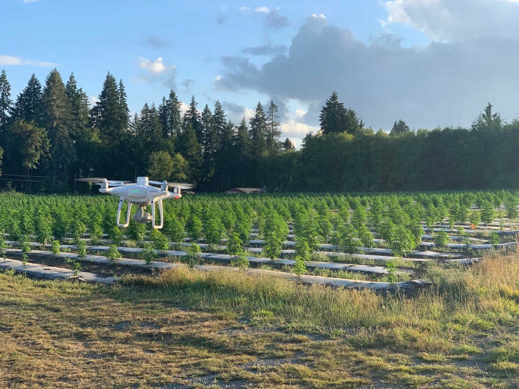
Similarly, a clear ROI picture can be derived from many agricultural operations. Among Blue Nose’s clients are cannabis and hemp farms. These operations, Harris said, are beginning to embrace drones for inspections because of the speed and accuracy they provide.
“Harvest optimization, yield estimations, disease and pest recognition—these concerns are applicable across the board for traditional precision agriculture regardless of the crop being grown,” Harris stated. “But cannabis farms have a unique challenge because they have to identify male plants at specific times during the growing season. If the male plants are allowed to grow to a certain stage in their lifecycle, they can cross pollinate with a female plant and that can ruin the yield on the order of 40% or 50% come harvest time. These are high-value crops, and cultivators can lose a lot of money if they don’t identify problems early.”
Using UAVs, cannabis operations can potentially shorten inspection times and provide more timely and accurate information.
“With traditional inspections, farmers just walk the rows and inspect the plants manually, and that becomes very time consuming,” said Harris. “When the farms employ remote sensing technology with drones and combine that with manual inspections, they can more accurately identify problem areas within the field. A problematic plant can be extracted before it leads to some pretty bad impacts.”
Harris cautioned that “male plant identification technology is still in its infancy, and reliably identifying male plants using drones is cutting edge tech and has yet to be fully refined.” In addition, he reported that a handful of groups in the industry are employing AI and machine learning for crop inspections, “but these techniques have yet to prove operationally feasible for outdoor farms because this is such a time critical point in the growth cycle for cannabis.” He pointed out that many cultivators are also transitioning towards indoor grows where water, nutrients, and light can be easily managed to optimize growth cycles throughout the year.
Despite the challenges, Harris stated that there is clear value in using drones for certain inspection and mapping operations. And he believes the industry will develop more accurate ways to measure and report this value. Much of this progress will depend on capturing better information about drone operations and outcomes.
“The more we understand about flight planning, the more we can analyze data from our operations, and the more we understand the ways we use personnel, hardware, and software, the more we will be able to accurately report ROI,” Harris asserted.


Comments