

As the volume of unmanned traffic increases, SkyGrid, a Boeing, SparkCognition company, wants to build an “aerial operating system” to safely integrate unmanned aircraft in the global airspace and enable autonomous operations. According to Zehra Akbar, SkyGrid’s senior director of strategy and operations, SkyGrid’s AerialOS is the only airspace management system built on AI and blockchain technologies. This enables the system to monitor, predict, and adapt to changing airspace conditions and fill gaps unaccounted for in today’s unmanned traffic management (UTM) solutions.
Recently, the company launched SkyGrid Flight Control, a free application for drone operators and enterprises to automate every phase of flight in one unified solution, further expanding SkyGrid’s accessibility and functionalities.
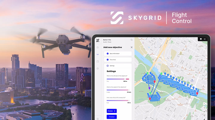
Powered by its AerialOS, SkyGrid Flight Control provides users with a map of airspace traffic, classes, temporary flight restrictions, notices to airmen, and other advisories, and displays population density, obstacles, elevation, and more for improved awareness. In addition, the platform automates authorization to fly in U.S. controlled airspace under 400 feet near airports through integration with the Federal Aviation Administration’s Low Altitude Authorization and Notification Capability (LAANC) 4.0. Moreover, it automatically generates area exploration, waypoint, and multi-objective missions based on custom flight parameters, such as desired speed, altitude, and location.
“We make it easy for drone operators to check the airspace, get LAANC, and generate a mission plan in a matter of minutes,” Akbar told Commercial UAV News. “Our system will sync with their drone as soon as a user connects their iPad to the drone controller. Users can then launch their mission to autonomously perform the predefined flight plan.”
Before Flight Control’s release, SkyGrid was working directly with select enterprises to provide custom deployments of its platform based on the needs of the customer. Some of the features that were previously only available to those select enterprise customers are now available to drone operators for free with the new app.
“We recognized the challenge many drone operators are facing today by using several different tools to check airspace, get LAANC, plan flights, and safely execute them,” Akbar continued. “It’s a cumbersome process that requires too many manual workflows and can lead to disconnected information as you switch between different applications. We set out to solve this challenge by providing one solution operators can use to manage their entire drone workflow.”
Over the last few months, SkyGrid has made several advancements to its platform, including the addition of AI computer vision capabilities and advanced flight planning capabilities. Deployed on the edge, SkyGrid’s AI computer vision in SkyGrid Flight Control enables drone operators to detect key objects, such as people, vehicles, and animals, in real-time during flight. This technology can be a powerful tool to quickly assess damage following a natural disaster, identify potential threats near critical infrastructure, or track assets and personnel at a construction site.
“For example, our solution can help first responders significantly reduce the amount of time required to locate and provide care for lost or missing persons,” Akbar added. “It will automatically generate a sweep mission to surveil a defined area based on the flight parameters, such as the desired altitude, speed, and distance between sweeps. Once the mission is launched, our solution will autonomously perform the predefined flight plan and allow first responders to monitor the flight in the live video feed. As the drone surveils the defined area, our AI computer vision will help detect the lost or missing person in real-time, enabling first responders to quickly identify the coordinates and evaluate conditions for ground accessibility.”
For organizations to better manage all drones, pilots, and airspace operations, SkyGrid Flight Control also introduces more advanced enterprise features at an additional cost, depending on the size, scope, and unique needs of each commercial drone operation.
“For enterprise customers, we can train our algorithms to detect and track customized objects based on the needs of the mission,” Akbar said. “We can also optimize flight planning with AI to generate the safest, most efficient routes based on the airspace conditions, vehicle performance, and mission criteria. With a Part 107 Waiver, our AI algorithms can also support multi-drone missions by optimizing the distribution of multiple drones over a defined area based on a defined timeframe or fleet size.”
Available for free in the iPad App Store, the company plans to extend the SkyGrid Flight Control app to Android soon. Additionally, SkyGrid is also working on new features and functionality to roll out in upcoming versions of the app.

.jpg.small.400x400.jpg)


Comments