

Drones are versatile, efficient tools that provide a unique perspective on our world. Equipped with mapping software, they are a go-to tool for professionals in a wide range of industries, including Agriculture, Construction, Mining, and Surveying. But with so many options available, it can be challenging to determine which drone mapping software is best for your specific project. In this article, we'll explore the key factors to consider when choosing professional drone mapping software.
Accuracy and Precision
One of the most important considerations when selecting drone mapping software is accuracy and precision. In many industries, such as construction or surveying, even minor errors can significantly impact the outcome. Look for software with high accuracy and precision ratings, ideally with less than one-inch error margins. Additionally, ensure the software is compatible with GPS or other location-based technologies to provide precise measurements.
Ease of Use
While accuracy is essential, so is the ease of use. No matter how accurate a software package may be, if it's too complex or difficult to use, it's likely to cause more headaches than benefits. When evaluating drone mapping software, look for packages with intuitive user interfaces and easy-to-understand workflows. Consider the level of training required for your team to operate the software effectively.
Compatibility and Integration
In addition to accuracy and ease of use, it's important to consider compatibility and integration with other software tools you may be using. For example, you may already have a preferred GIS (Geographic Information System) or CAD (Computer-Aided Design) software package that you need to integrate with your drone mapping software. Make sure the software you choose can work seamlessly with your existing tools.
It is also important to take the drone you're using into consideration. Although some drone manufacturers have their own compatible software solutions, like DJI Terra, or Percepto, which are compatible from the get-go, that doesn't stand true for third-party solutions. Make sure your drone is recommended for or compatible with your selected software.
Data Processing and Analysis
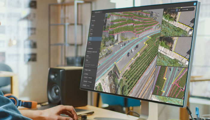
Drone mapping software is only as good as the data it provides. Make sure the software you choose offers robust data processing and analysis capabilities. The software should be able to generate 2D and 3D maps, orthomosaics, and point clouds. It should also be able to provide detailed data analysis, including volumetric calculations, elevation models, and vegetation indices.
Cost
Of course, cost is always a consideration when choosing any type of software. Remember that the most expensive option isn't always the best, and the cheapest option isn't always the worst. When evaluating drone mapping software, consider the total cost of ownership, including any ongoing maintenance or support fees. Also, consider the return on investment (ROI) the software may provide.
Support and Training
Finally, consider the level of support and training the software provider offers. Is a dedicated support team available to help you troubleshoot issues or answer questions? Is there an online knowledge base or community forum available to help you quickly get up to speed with the software? Does the software provider offer training or certification programs to help you and your team proficiently use the software?
In conclusion, choosing the best professional drone mapping software for your project requires careful consideration of various factors. While there are many drone mapping software solutions on the market, each with its unique features, capabilities, and pricing structures, here are some of the standout ones:
DroneDeploy
From drone fleet management to complete site documentation and analysis, DroneDeploy aims to save time and money while reducing risks by offering real-time progress tracking and collaboration tools and making sharing data with team members and stakeholders easy. The cloud-based drone mapping software allows users to create high-resolution 2D and 3D interior and exterior maps and models with a 1 to 5cm accuracy. It offers a range of features for many different industries, including Agriculture, Construction, Oil & Gas, Inspection, Mining, and Utility.
Supporting a wide array of drones and cameras, from cheap to expensive ones, DroneDeploy offers an easy-to-use and intuitive interface, as well as an app ecosystem supporting many well-known apps, such as Azure, Google Drive, Autodesk Construction Cloud, and AirMap. Regarding customer service, DroneDeploy has a team of experts available to answer any questions through chat, phone, or e-mail.
Pricing for DroneDeploy starts at $3,948/year for the Individual plan, with additional features available at higher tiers. There is also a cheaper Agriculture plan, Ag Lite, which starts at $1788/year, and a 14-day free trial for all new Individual plan users.
Pix4D
Pix4D is another cloud-based drone mapping software that offers robust features to generate accurate 2D and 3D maps and models with a survey-grade accuracy down to less than 1cm for Surveying, Construction, Agriculture, Telecom, Mining, Inspection, and more industries. According to the company's website, Pix4D is the only photogrammetry software suite for mobile and drone mapping with a flight app, desktop, and cloud platforms.
To make it more accessible to users from different industries, Pix4D allows you to pay for what you need by offering separate general and industry-specific software - for example, PIX4Dinspect for Telecom, PIX4Dfields for Agriculture, PIX4Dreach for Emergency Response, and PIX4Dcloud Advanced for Construction. PIX4Dmapper, PIX4Dsurvey, PIX4Dmatic, and PIX4Dcloud are more general mapping solutions. Prices range from $400/year up to $3,300/year, with some applications featuring a perpetual license, like PIX4Dmapper, which costs $4,400 for life.
Since Pix4D's software is image acquisition app agnostic, PIX4Dmapper, PIX4Dcloud, PIX4Dmatic, PIX4Dreact, and PIX4Dfields can process images taken from any application as long as they are of good quality and overlap. Due to its extensive product offer, Pix4D created a quiz to help new users determine the best solution for their projects.
Propeller
Propeller is also a cloud-based drone mapping software that offers a range of features tailored specifically to the Construction and Mining industries. Propeller's PPK solution lets users map, measure, and track a project's lifecycle with visual tools accessible from any device, anywhere, and anytime. The software uses photogrammetry to quickly create detailed 3D site models, allowing users to run volume calculations and cut/fill analysis.
With a focus on Construction and Mining, Propeller offers tools that other mapping software do not, such as Elevation Difference, Road Grade, Surface Area, Design to Design, Volume from Lowest Point, Earthworks Progress, Elevation History, Cross-Section Comparison, Compare to Previous Survey, Berm Check, and Compare to Latest Design. However, unlike Pix4D and DroneDeploy, Propeller requires the use of smart ground control points, AeroPoints, to reach high-precision mapping (accuracy of 1/10ft (3cm) or under), and DirtMate, an easy-to-install, cost-effective machine tracking system that integrates seamlessly with drone survey data, to take full advantage of Propeller's solution.
Propeller customers receive dedicated, unlimited support for data processing and training. With more than 100 employees in Australia, the USA, the Netherlands, and the Philippines, users have 24/7 access to specialized support for any software or hardware concerns. While Propeller supports various types of drones, the recommended ones are the DJI Mavic 3 Enterprise, Phantom 4 RTK, Matric 300 RTK, WingtraOne, and Quantum-Systems Trinity F90+.
The company offers two purpose-built payment plans, Annual Credit Packs and Drone Unlimited.
Agisoft Metashape
Agisoft Metashape is a stand-alone software that generates 3D spatial data from photogrammetric processing of digital images for GIS applications, cultural heritage documentation, visual effects production, and indirect measurements of objects of various scales. The software offers unique tools, such as editing and classifying dense point clouds, terrestrial laser scanning registration, ground control points/scale bar support, stereoscopic measurements, hierarchical tiled model generation, 4D modeling for dynamic scenes, automatic power line detection, and satellite imagery processing.
Unlike the previously mentioned software, Metashape only offers two distinct payment options. Users can pay $179 for the processing tool, enough to create models from drone data, or $3,499 for the complete package, which includes tools that may not be relevant to you as a drone pilot, such as 3D modeling texture tools used for industries like video game design. On a positive note, every license is a one-time purchase and includes 12 months of e-mail-based technical support.
While the drone mapping software mentioned above represent some standout options, they are not the only or best available. When selecting the best software for your specific needs, it's important to research, evaluate multiple options, and consider the factors initially mentioned in this article. With so many solutions available, there's no single right choice.


Comments