

A large number of countries have a presence in Antarctica; some have permanent bases, but most have summer locations that they occupy during the “warm” months. Ecuador is one of the many countries that have a seasonal presence in the southernmost continent, but their budget for scientific research is small and their time in the region is limited.
The entity in charge of the base and its personnel during the summer months is the Ecuadorian Antarctic Institute (INAE). In order to implement a much-needed expansion at the facility, INAE partnered with the Ecuadorian mapping agency to select an unmanned aerial vehicle (UAV) to be the platform of choice for all cartographic flights in the country, including Antarctica.
Several UAV manufacturers were invited to participate and bring the specifications of their various platforms to the table. The only vehicle that guaranteed stabilized flight with winds of 65 km/h (40 m/h) was the Trimble UX5 (Trimble later sold the UAV business division to Delair Aerial Intelligence). The local distributor of Trimble in Ecuador was therefore invited to bring one aircraft to the Antarctica for the ultimate test: to map the area surrounding the scientific research base in Antarctica. It would be one of the first times that a UAV had been used in Antarctica.
Ecuador’s Maldonado Base is situated at Guayaquil Bay on Greenwich Island in the South Shetland Islands, just a few miles off the coast of the Antarctic Peninsula. The base supports scientific research programs in biology, geology, glaciology, and microbiology, among other disciplines. Faced with a tight timeframe and unpredictable conditions, INAE wanted to prove that a small, lightweight unmanned aircraft could provide a suitable orthomosaic of the Ecuadorian research base and the surrounding area.
The UX5 distributor agreed to supply a Trimble UX5 aerial imaging rover, processing software, and a technician to assist in the month-long mapping operation at Maldonado Base. The plan was to download mission data obtained after each flight to aerial photogrammetry software, which then performed automatic adjustments and produced 3D colored point clouds and digital surface models, as well as orthophotos of the area flown.
Timing was critical. Planning commenced in late November, and the expedition needed to leave in February in order to be completed before the Antarctic winter set in. They had less than three months to prepare.
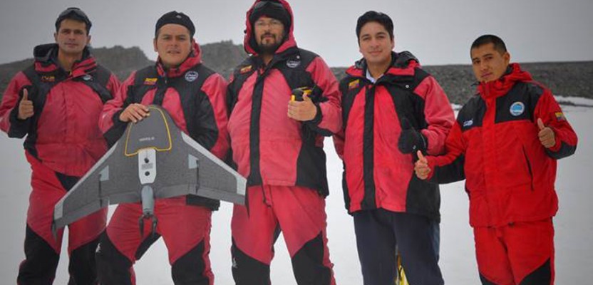
Jorge Berenguela was the technician selected to make the expedition and fly the UX5. An experienced UAV pilot, Jorge had flown its predecessor, the Trimble Gatewing X100, but was new to the UX5 and would need additional training on the new aircraft. Jorge completed training and certification shortly before the departure to Antarctica.
The mapping team consisted of Jorge and four INAE scientists. Departing from Quito, Ecuador, they flew to Punta Arenas, Chile, near the southern tip of the South American continent, where they had to wait for three days for the weather to clear—a preview of things to come. From there, a C130 military cargo plane took them to King George Island, the northernmost tip of the South Shetland Islands. After another two-day delay due to bad weather, the team embarked by boat to Greenwich Island, roughly 50 miles away, on which Maldonado Base is located.The research station receives three expeditions each year. The first group arrives in early January to open the base and prepare it for the arrival of the scientists. The UX5 team would be members of the third contingent. The total expedition comprised 38 people including biologists, microzoologists, cartographers, weather experts, and soldiers. Accommodations were cramped: four men shared a 6 by 6-foot room, sleeping in bunk beds.
For several days after arrival, base safety regulations prohibited the team from going outside due to bad weather. Although the UX5 could perform under difficult conditions, for the operators it was another matter. On more than one occasion, the base commander prohibited personnel from working outdoors during periods of extreme cold, high winds, or heavy precipitation. To complicate matters, the team would be conducting aerial photography over snow and ice—one of the most difficult challenges in photogrammetry.
Once the weather finally improved to allow human outdoor activities, the UAV team was able to launch the first flight of the UX5. But conditions were still challenging: 5ºC (23ºF) and winds of 10 to 15 knots with unpredictable gusts.
The first flight was a success; it landed smoothly after covering the entire scientific base in about 25 minutes with an overlap of 80% at an altitude of 100 m (250 ft).
However, bad weather returned, keeping the team confined indoors for several more days. Then, when they could finally launch the second flight, it was aborted after just seven minutes when the weather suddenly changed for the worse. Again, the team spent several more days waiting for the weather to moderate, allowing them to leave the immediate base area. Time was running out, and the final objective to fly the entire peninsula was still in doubt.
Finally, the weather improved, and Jorge and the team quickly took advantage. Everything worked as planned: the UX5 climbed to 180 m (600 ft) and flew for 45 minutes, covering the entire peninsula with the planned overlap of 80%. When the aircraft landed, the entire IGM team embraced in a “mission-accomplished” group hug. They had overcome challenging conditions and narrow weather windows to achieve their goals.
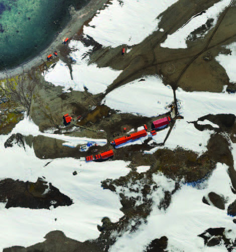
Orthophotomosaic of Maldonado Base
With the flights completed, Jorge processed the images and the resulting ortho-rectified, georeferenced photomosaics of the peninsula and the base area were beautiful and provided excellent detail. Despite the difficult and rapidly varying weather, the UAV had proven its worth and now the expansion plans are underway, thanks to the perseverance of the team and the reliability of the platform.


Comments