

Since 2020, the non-profit organization Wilderness International has been partnering with Quantum-Systems to protect rainforests. Integrated drones and sophisticated imaging technology have aided Wilderness International in its mission to preserve “unique intact natural areas” around the world.
Recently, Commercial UAV News spoke with Martin Herkommer, Senior Manager, Global Commercial Sales at Quantum-Systems, who flew missions for Wilderness International in Peru, along with Claudia Steinhoff, Marketing Manager at Quantum-Systems. They explained how Quantum-Systems helped the non-profit use drones equipped with Sony RX1 and UCM cameras to assist in image capturing, mapping, and data processing.
Commercial UAV News: When and how did Wilderness International recognize the capabilities that multispectral cameras would enable for them in their efforts to protect unique natural areas?
Steinhoff: In 2020, Wilderness International was using low-cost camera solutions mounted to multicopters for mapping in the tropical rainforest. Early 2021, Wilderness International approached Martin Herkommer at Quantum-Systems and its partner Pix4D to find out if there was a more professional method to map a huge area of land, such as the tropical rainforest of the Amazonas. Quantum-Systems offered their help using the Trinity F90+ with various professional camera systems, including Sony RX1, MicaSense Altum, and Quantum-Systems Qube 240 Lidar.
Commercial UAV News: On a technical level, what is it about the Sony RX1 and UMC cameras that makes them such an ideal fit for this application? Are there specific technical advantages that these cameras have over other available camera options?
Herkommer: The Sony RX1 is probably the most sophisticated high resolution RGB camera for use on UAVs. With 42 MP and a very low weight, the camera does not compromise on image quality. The RX1 comes with a flash hot shoe mount which helps logging the exact trigger times for later PPK postprocessing. Using this technology together with the Quantum-Systems PPK system, the final ortho photo will have an absolute accuracy of 2.5cm. The UMC is the lower cost solution with less pixels (only 21MP). With the RX1 a user can do more with the same final ground resolution by flying higher and safer.
 Commercial UAV News: What additional opportunities did integrating the cameras into drones open up for the team?
Steinhoff: Drones are simply a tool to take any kind of camera or sensor into the sky. It’s all about remote sensing and capturing sharp and reliable imagery as well as sensor data from the air. Once the cameras are integrated, the drones are used for various applications. The images are not just used for 2D mapping, but also for 3D data processing. And with photogrammetry tools, the overlapping aerial images can be processed into Digital Terrain Models (DTM) and Digital Surface Models (DSM).
Commercial UAV News: Were there any adoption challenges that the team had to sort through? What type of learning curve is there for anyone that is or isn't familiar with using multispectral cameras?
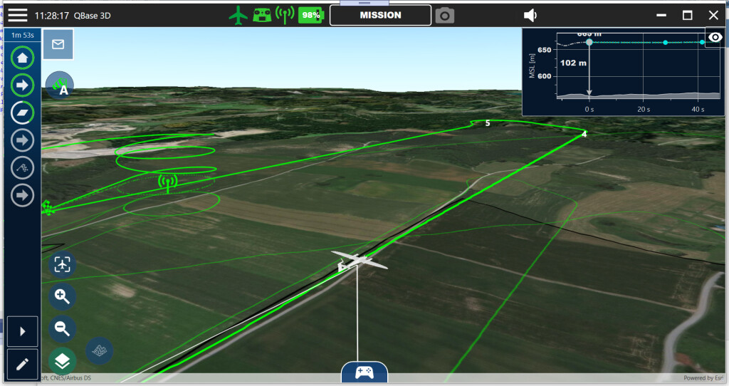
Herkommer: The Quantum-Systems drones are designed to be smart and autonomous. This means no pilot skills are necessary to map the tropical rain forest. The planning is done on a laptop with a 3D mission planning tool called QBase3D, which was designed by Quantum-Systems. Once the images are captured, the team uses the smart Pix4D Image Processing software PIX4Dmatic (for RX1 data) and PIX4Dfields (for the multispectral data). Both software packages are designed to be fully automatic, so there isn’t much knowledge necessary to produce the final output.
Commercial UAV News: Are there distinctions with how the georeferenced data and high-resolution photographs captures by the cameras and drones can now be utilized by scientists? How much more can scientists now do with this imagery when compared to their traditional approach to capturing this type of information?
Steinhoff: Well, with modern remote sensing software and GIS (Geographical Information Systems) there is so much more that scientists can do. For example, they can calculate biomass and carbon storage for different parts of the tropical forest.
Commercial UAV News: What advice would you have for me if I said the Sony RX1 and UMC cameras sound like they could be a fit for my next project, but I need to have a better understanding of what kind of a difference these solutions could make before taking that next step?
Herkommer: The main difference between RX1 and UMC is the resolution and of course the price. With a RX1 the user can map much more area within the same flight time by flying higher but producing the same pixel resolution as on the ground.


Comments