June 25, 2018
ASPRS Certification of UAS Mapping Professionals: Why Does It Matter?
In the span of five short years, technology barriers for mapping small areas of interest in high detail with high accuracy have been significantly reduced. This is largely due to the rapid development of Unmanned Aerial Systems (UAS) outfitted with compact digital cameras. In addition, commercial proliferation of highly automated, user-friendly software programs for flight planning and execution, image processing, 3D modeling, and map product generation make it possible for almost anyone with the appropriate FAA Part 107 certification to create topographic maps and orthorectified imagery.
While it may be appropriate to use those products internally or for a single specified use, digital data such as these can easily be distributed and eventually relied upon for other purposes. Furthermore, if ground control is established for the purposes of georeferencing or assessing the accuracy of the UAS-derived products, or if topographic maps are published for engineering or landscape design, the surveying activity may fall under the definition of licensed surveying practice in most, if not all, US states.
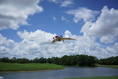
Consider an example of a mapping created for a local golf course to aid in redesign of several fairways. The golf course owner can make use of this information to plan modifications, but the mapping might then be passed along to a county agency to determine if the redesign effects the local watershed - a use that may not have been properly addressed by the original mapping specifications. What if the mapping is relied upon by a landscape architect who, in turn, discovers that contours derived from the UAS mapping do not match existing countywide data even though the mapping agreed with independently surveyed GPS checkpoints? Who is responsible for resolving discrepancies or liable for faulty design created from the contours?
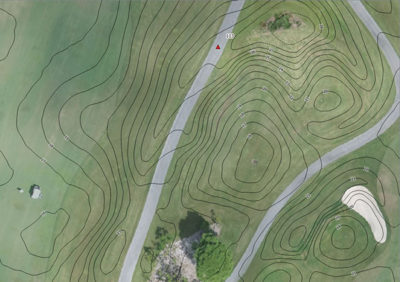
You may assume there can’t be anything wrong with the contours provided; after all, they were created directly from the DSM; it's just another step in the automated process - create the DSM and generate contours...simple. However, is it that simple? While you are asking yourself this question, the landscape architect has now hired another surveyor and concluded that the DSM is incorrect. The client is upset because they now believe they have received (and paid for) faulty data; the landscape architect who relied on the data is incurring delays and added expense. How did this happen? The UAS system was supposed to be turnkey; the processing software is rock-solid and very user-friendly. What went wrong?
Maybe it is not the software; maybe the problem originated in the way the data was acquired and processed. Was the aerotriangulation properly constrained? Was the ground control correctly placed? Was the correct vertical datum used? Was the camera properly calibrated? Was real-time kinematic GPS used in the solution? What were the GPS conditions during acquisition? Was PDOP acceptable? Did sunspot activity affect the ionospheric corrections? Could you even answer all of these questions adequately if confronted by an upset client or his attorney’s expert witness? One thing is for sure, one wrong step in project planning or processing can have a major effect on the accuracy of your deliverables. Your ability to control error and accuracy, troubleshoot your processing steps, document and explain the GPS and aerotriangulation solution in a credible manner will depend on your level of education, training, and experience.
ASPRS Certification is for those in the mapping profession who want be recognized as qualified, peer-approved UAS mapping professionals. It is designed to separate those who are merely owners of technology from those who have an understanding of the principles of mapping from aerial imagery. An ASPRS UAS Certified Mapping Scientist has demonstrated mastery of the processes and methods used to produce many different mapping products and is able to make assurances of the accuracies associated with those products. A UAS Certified Mapping Scientist understands and can quantify errors associated with the choice of equipment, acquisition conditions, and processing methods used to create the final deliverables. Simply put, ASPRS Certification assures your client that you have the experience and skills to provide the mapping services requested.

Developed in 2017, the ASPRS UAS Mapping Certification includes the following requirements: demonstration of hands-on experience under appropriate supervision, references from peers who are familiar with your work and professional ethics, and a knowledge-based, proctored written exam. This formula has been used by ASPRS for over 60 years for Certifications in photogrammetry, remote sensing, GIS, and lidar. ASPRS is widely known as the society that develops and publishes accuracy standards for all types of mapping in the United States. ASPRS certified professionals are also required in many local, state, and federal government agency solicitations.
Finally, as your UAS mapping business expands, you may begin looking into other remote sensing systems, including manned platforms and other sensors such as lidar, thermal, and hyperspectral imagers. Your ability to provide these services will likely require you to acquire new knowledge and skills as technology continues to evolve. ASPRS is here as a resource to provide the education and certification programs validating your commitment in the geospatial world.
The ASPRS UAS Technical Symposium is being offered as an add-on to either Full Conference or Exhibits-Only registrations for Commercial UAV Expo Americas 2018, which takes place October 1-3 in Las Vegas. To register for the event, click here. 


Comments