

Gaining a complete, accurate, and validated picture of the airspace has been a major safety and security challenge for the drone industry, but it is also key to gaining advanced regulatory permissions and enabling the enterprise. The challenge, as well as the solution, is multi-faceted. On the one hand, we have the FAA working on the final ruling on Remote ID, which will enable us to see compliant drones in the airspace, but this doesn’t do anything for protecting users from unauthorized players. On the other hand, drone detection systems, which are capable of detecting everything including unauthorized users, are not only expensive but also cumbersome, difficult to maintain and operate, and usually only cover a specific location or area, offering users a very small window in which to react to unauthorized players.
These are challenges that Hidden Level identified based on their years of experience developing advanced sensor technologies in the defense and commercial sectors. They realized that there aren’t many scalable solutions in the commercial drone space, and they came up with a plan to address those challenges: a custom-built distributed sensor network called the Airspace Monitoring Service.
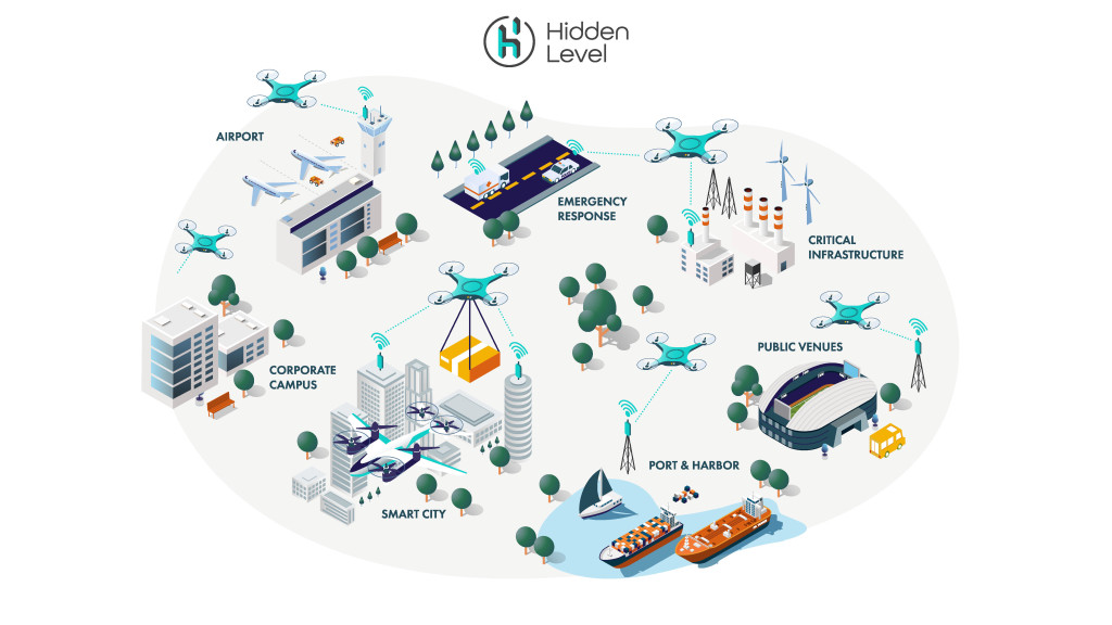
This network is set up in urban centers where there is a need due to dense drone activity— similar to how cell tower infrastructure is installed around the globe. Once the network is in place, multiple users can then subscribe to Hidden Level’s drone detection service to receive real-time airspace information. Because Hidden Level takes care of installing, operating, and maintaining the drone detection infrastructure, they are able to remove that high barrier of entry for many drone operators and services, which, in turn, enables them to scale their operations.
 In an exclusive interview with James Licata, Business Development Manager at Hidden Level Inc., Commercial UAV News was able to discuss the particulars of their custom-built distributed sensor network, how they are able to install this network to scale, how it can augment Remote ID, and much more.
Danielle Gagne: Can you tell us a little bit about the history, mission, and experience of Hidden Level?
James Licata: We are heavily experienced in the defense world, providing solutions for radar, passive RF, active electronic warfare, and communication solutions. The team has, on average, 12 years’ experience in this area.
From these years of experience, we realized that there was a problem that none of the systems out there, even some of the ones we worked on, could really solve, which was an ability to scale. That is how Hidden Level got started. We had learned a lot about what the industry was going to need, and we thought we’re the ones that could provide a sensing solution that could scale and solve that problem. With that, we went full bore into developing a commercial-based solution that could actually scale and meet the needs of the industry.
What are some ways you have been able to make Hidden Level scalable?
We are radar guys at heart, and some of the solutions we have employed and tested are great solutions, but they can be overly expensive for what is called for, especially for a single customer to use. And the level of radar installation required for employing this technology just doesn’t scale.
For example, one of the experiences I had was working on the FAA Pathfinder Program with the BNSF Railway. We used ground-based radar to help them in certain areas with their beyond visual line of sight inspection of the railway. When you look at BNSF, our solution was great for the early testing that they were doing and for establishing requirements and proving concepts to the FAA. But, when you look at BNSF, they operate on 32,000 miles of railway and expanding that solution at that particular price point when combined with obtaining the frequency authorizations and deconflicting with other systems that may be in use—it wasn’t scalable in that way.
We realized that there are potentially other customers with similar needs along those 32,000 miles of track, or within and around them, it became evident to us that a solution could be utilized by more than one customer type in an area where drone operations are likely to occur. This kind of solution seemed like a natural fit.
You are able to provide multiple customers access to this shared sensor system because you developed a distributed custom-built sensor network. Can you talk about how this works?
Some of the biggest burdens on the industry is going through the undertaking of not only evaluating a system’s capabilities, but also owning and operating that system, which includes keeping the system up to date and servicing it. We wanted to eliminate all those things for our customers by offering a solution that has a low barrier to entry and that can be easily plugged into what they are already doing, and that they don’t need to own, operate, or maintain.
We do this by deploying our own infrastructure. You can think of this as somewhat similar to how a cell phone company introduces coverage to a new area—that’s what Hidden Level is doing for drone detection. With that we’ll be able to provide companies with just what they need. Whether it is on the integration side, needing to know whether there are low flying, perhaps unauthorized, UASs in the vicinity or along their flight paths, or for security personnel who need actionable data about what is in the airspace. We’re looking to alleviate the burdens that we’ve seen, endured, and heard our customers talk about numerous times.
Because Hidden Level is going to be building that infrastructure, similar to how cell towers need to be installed to provide coverage, what are some ways you are able to fund that level of integration? Are you developing relationships with cities, states and the government, or are you relying more upon private venture capital?
There is a little bit of everything in that respect. It’s a combination of utilizing cities that are looking at the forefront of enabling Smart City applications in a safe way, utilizing public/private partnerships, as well as our own internal and private investments to make it happen.
In some cases, it is a situation of “if you build it, they will come.” We’ve been in this space a long time and we understand that you need to be able to prove that you can provide a product and service that people will want to use. By investing in infrastructure and deploying our sensors, we’ll be able to showcase its abilities and provide data to folks and make the case that it is easy to use, and that we are providing the best product out there.
Your company specializes in addressing the challenges of integrating drones into the NAS around urban centers—can you talk about the unique challenges that urban centers present and ways that Hidden Level are addressing those challenges?
Urban centers are really the crux of where UTM is going to be as well as where the most potential for denser commercial operations are going to occur. There is a high population density as well as critical infrastructure like airports and public venues like stadiums that will require the same conceptual need for a drone-based solution to be able to ensure the safety of the low altitude airspace.
Within urban centers you are dealing with everything from RF interference from multiple commercial users operating within the same frequency bands to multipath issues caused by urban canyons, which affect how RF signals bounce around, and so on.
We have focused on things like warning time. Having a single point solution only gives you so much warning time to react. If you were plugged into a system where points are more dispersed throughout the city, you can detect things much sooner in places like urban canyons, and then have the appropriate time to plan and react. For example, if you have a drone going 20 meters per second, having only a one-kilometer heads up time isn’t going to give you enough time to plan a response. But if you can get a notification through our Airspace Monitoring Service 10 to 20 kilometers out and can tell it is headed your way, you can be a bit more proactive.
Something we haven’t discussed yet but is important to note is that your sensor doesn’t require Remote ID for it to detect objects in the airspace. And, because it is a distributed network it can get heading and location information by being picked up by multiple sensors located throughout an area. This adds a level of safety and airspace awareness that even Remote ID won’t be able to provide for non-compliant drones. Do you think solutions like yours is the other piece of the safety puzzle?
I know there some concerns that the community has with Remote ID and, in some cases, rightly so. We all need to work together to make sure that it becomes what we all hope it can be, but it is not a silver bullet solution—it is a step along the way. Although the majority of the focus has been on the security aspect of Remote ID, as we move forward and evolve into UTM, I think the operational aspect of how Remote ID is used is going to be important.
From Hidden Level’s perspective, that is going to involve validating the airspace, and ensuring those position reports are accurate. Even if a drone is valid and squawking, its reported location does not always necessarily line up with its actual position in the airspace. As we start increasing the density of operations in low altitude airspace, we will have to start thinking about some of these problems. Beyond that, there will be those who aren’t complying with regulations or getting proper LAANC authorizations—and those operators need to be checked and accounted for as well to have a complete safe picture of the airspace.
Can you talk a little bit about the testbed deployment in Syracuse NY? What were some key takeaways you have learned from that project?
Syracuse is an interesting area because it really is a hotbed of radar and sensor expertise. But beyond that, New York State is invested in the Rome FAA test site and building out a corridor to test UAS activities, and then we have a large ecosystem of folks innovating in the drone space. So, it really makes this area great for us to test, deploy, innovate, and learn.
Right now, with the corridor work, it’s really focused in the area between Rome and Syracuse, with Hidden Level’s focus on urban centers. So, we are focused on covering the city of Syracuse and surrounding airport and testing the various scenarios that we can help out with. We have opportunities to use our test bed to help with things like the Syracuse smart city initiative: Syracuse Surge, where we can supply data about low altitude airspace usage to inform the potential of future municipal efficiencies, which translate to other initiatives we are seeing across the country. The testbed also allows us to work with our customers and partners on validating use cases and solutions, making sure the airspace is safe for everyone looking to access it.
What are some key takeaways you would like our readers to remember about Hidden Level?
We have had our heads down for a while now working on perfecting a solution that has been based on years of experience in this domain and lessons learned along the way. We want to share that knowledge with everyone. We know that in order to have a safe and equitable use of low altitude airspace we are going to need to validate its safety, and we think that our sensor network is a great way to accomplish that. We believe we can lower the barrier of entry enough that it makes sense for the industry to support it. Our goal really is to enable safety through sensing—that is what we are passionate about.

.jpg.small.400x400.jpg)


Comments