

On February 20, the National Transportation Safety Board (NTSB) released a report stating that the December 30, 2023 collision between a drone and a helicopter at Daytona Beach Airport (KDBA) in Florida was a mid-air collision and both pilots were at fault. 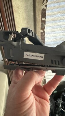 The report differs from the preliminary assessment of the incident by the NTSB which contained inaccuracies that highlight the many challenges of investigating collisions between drones and traditional aircraft.
I reported on this incident back in January, shortly after the incident took place. Before writing the piece, I was contacted by the drone pilot who revealed to me how events unfolded from his point of view. His description compelled numerous questions about the collision and the possible conclusions that would be drawn by investigators not familiar with uncrewed aviation.
On January 25, the NTSB published a final report which mentioned that the defining event of the accident was a collision with an “Object/Terrain.” It also blamed the accident on the pilot of the “Other Aircraft.” The report had a comprehensive section with details concerning the helicopter and the helicopter pilot, but it failed to mention the drone or the drone pilot. These missing items made the collision look like it was between a legal helicopter and a rogue drone.
Noting these omissions and mistakes, I wrote a comprehensive report on January 26 and sent it to both the NTSB and the FAA. My report outlined in detail the missing sections and pointed to some issues that are unique to uncrewed aviation, such as Geofence. It was immediately apparent to me that the investigative agency was having trouble reconciling the fact that these two aircraft were legally registered with the FAA and both pilots had valid FAA licenses.
It is important to note that the NTSB and FAA investigations are different and have different goals. NTSB reports are public, and these reports are typically restricted to a listing of the facts, aircraft, and pilots involved and the possible causes. FAA reports are private, and they usually dig deeper into the real causes of the accident, such as maintenance issues, pilot certifications, aircraft deficiencies, toxicology reports, etc.
The issues that we called out as needing to be updated were:
- This was not an “object/terrain” collision but a midair collision.
- The report should have included a section dedicated to describing the drone, including brand, model, serial number, and FAA registration number.’
- The report should have included a section dedicated to the drone pilot, including age and validity of license.
- That the drone was flying under Part 107.
- That the helicopter was flying too low.
On January 31, the original report was removed from the NTSB website. Then, on February 15, I received a call from a representative at the Office of Aviation Safety, National Transportation Safety Board. They thanked me for my contributions to the investigation and mentioned that the new report would be republished in a few days and would take into account some of the issues that I raised.
 Now that we have the report in hand, and the NTSB investigation is over, we can mention some of the issues that made it possible for a drone and a helicopter to collide so close to an international airport. It is worth mentioning that every aspect of our report to the NTSB was included in the final accident report.
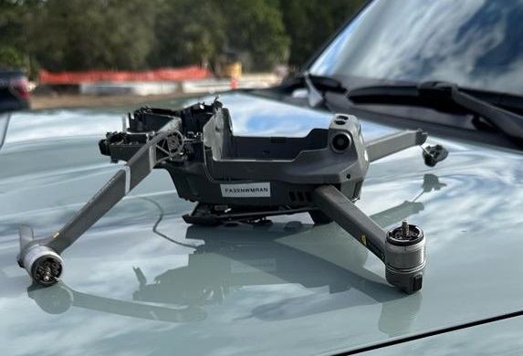
The drone pilot was conducting a photogrammetry flight at 180 feet Above Ground Level (AGL), and he had flown the same mission eight times before in what is called a “Construction Follow up Flight” in which the same area is mapped every week to monitor how a construction site evolves. Given the proximity to the KDAB airport, the drone was operating under a Certificate of Waiver or Authorization (COA) that specified 150 feet as the maximum altitude, so the drone was 30 feet higher than authorized by the FAA.
The drone pilot had conducted the same flight at 180 feet on the following dates:
- Friday, November 3, from 1:21 pm until 5:46 pm aprox.
- Friday, November 10, from 9:51 am until 1:51 pm aprox.
- Saturday November 18, from 9:41 am until 2:25 pm aprox.
- Thursday November 23, from 10:29 am until 2:32 pm aprox. (Thanksgiving)
- Thursday November 30, from 11:15 am until 1:40 pm aprox.
- Thursday December 7, from 11:04 am until 1:20 pm aprox.
- Friday December 15, from 10:13 am until 12:32 pm aprox.
- Thursday December 21, from 11:12 am until 2:03 pm aprox.
Using public data from FlightAware, we plotted the helicopter (N828AK) flights to determine if the drone and the helicopter had operated in the same airspace before.
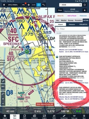
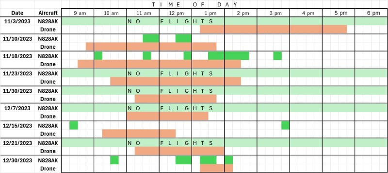 As you can see, N828AK and the photogrammetry drone shared the same airspace without conflict seven different times, including a previous flight on the day of the accident. One important fact to note is that the airport of Daytona Beach International issued a NOTAM (Notice to Aviators) alerting that there was UAS activity in the area in which the accident occurred and specifically mentions the altitude from Surface to 200 feet. The accident occurred at precisely 180 feet, so the helicopter was 20 feet below the restriction imposed by the NOTAM.
 The COA for drone operations in this case also specifies that the drone pilot had to contact the KDAB tower 15 minutes in advance of operations. The drone pilot did not call the tower and was flying 30 feet above the authorized altitude.
That seemingly makes it easy to conclude that both pilots were at fault in the accident, but the reality is far more complicated. The COA was issued to the construction company Clayco Corp., in March 2023 and specifically mentions a Clayco employee as “Responsible person for the safety of UAS operations under this COA.”
Clayco Corp then hired DroneHive of Park City, Utah to perform the flights. DroneHive then hired a local pilot in Daytona Beach, Florida to actually fly the photogrammetry missions.
The real cause of this accident is that the Clayco employee responsible for the safety of UAS operations under the COA never talked to the pilot and no briefing session ever took place to make sure the pilot understood the safety requirements of the COA.
On the first mission on November 3, 2023, the drone pilot attempted to fly and the DJI drone refused to comply due to its proximity to the KDAB airport. The drone pilot contacted his employer, and, a few minutes later, DroneHive sent the COA via email. The drone pilot sent the COA to DJI, and DJI unlocked the drone, allowing the flights in the vicinity of KDAB.
This unlocking of the drone gave the drone pilot a false sense of security, and he performed the flight at 180 feet without noticing that the limit was 150 feet.
For eight weeks in a row, the drone pilot submitted his flights, and the resulting maps to Clayco Corp. in an online application that the construction company uses to monitor all its projects countrywide.
In conclusion, this accident happened because of the following issues:
- The responsible person under the COA never briefed the drone pilot.
- DroneHive hired the pilot and sent the COA but did not read the COA or brief the pilot.
- The drone pilot did not read the COA.
- The personnel at DJI did not read or understand the COA and unlocked the drone at an unauthorized altitude.
- The helicopter pilot either ignored or was not aware of the NOTAM and flew too low right into the path of the drone.
With the release of the final report, the NTSB has now established a clear precedence in which future investigations of midair collisions between crewed and legally registered uncrewed aircraft can be based.
This accident is a stark reminder to all drone pilots that when they take off, they are entering a system that has existed for decades and has an amazing safety record. Thankfully, there were no fatalities either on the helicopter or on the ground, but the potential for disastrous consequences is there every time we take to the skies and share the National Airspace with our colleagues from traditional aviation.
This incident underscores how important it is for crewed and uncrewed aviation professionals to realize that we have entered a new era. It is an era in which both types of aircraft will be in close proximity to one another, and need to be able to share the airspace in a way that everyone understands. Only common sense and strict adherence to rules and regulations will prevent further accidents.


Comments