

Using drones to help in the detection, containment, and extinguishing of fires is rapidly becoming a widely adopted solution by first responders. While many find drones to be a helpful tool to keep overwatch of teams on the ground for improved situational awareness, or to put out fires, the Fire Weather Research Laboratory (FWRL) at San Jose State University is looking into a subject most people neglect: the vertical profile in the wind.
Focused on understanding how the atmosphere influences wildfire behavior as well as how those fires influence the atmosphere, the FWRL has been conducting meteorological profiling of wildfires using UAS. With over 3,544,030 acres burned from September’s wildfires and the release of large amounts of carbon dioxide, black carbon, and brown carbon into the atmosphere, the FWRL believes studying the vertical profile of the wind is critical to understanding those behaviors.
“One thing that we know about fire behavior is that the vertical profile in the wind has been shown to cause erratic fire behavior,” says Craig Clements, Ph.D., Professor, Fire Research Laboratory, Wildfire Interdisciplinary Research Center, San Jose State University. “If it's got a strong wind shear—you've got wind blowing at the surface in one direction and you have wind going above that layer in the opposite direction—you can get erratic fire behavior.”
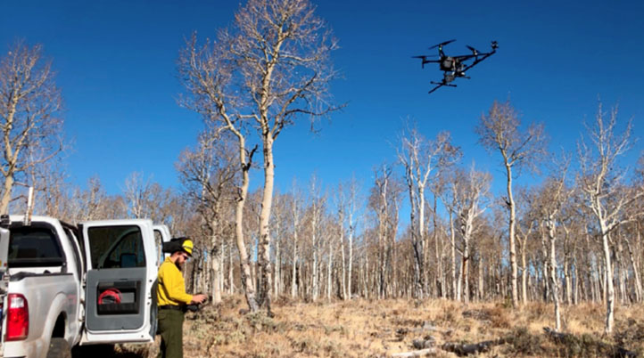
Together with the United States Forest Service (USFS) and the Desert Research Institute (DRI), the FWRL has sampled the vertical wind profiles of 3-dimensional (3D) winds generated by wildfires using a DJI Matrice 200 (M200) equipped with a TriSonica Mini Wind and Weather Sensor from Anemoment. Mounted on a carbon fiber pole extending 55 cm off the body of the drone to avoid rotor wash, FWRL’ solution records three components of wind speed (u, v, w), wind direction, sonic temperature, humidity, pressure, magnetic heading, pitch and roll rates up to 5 Hz.
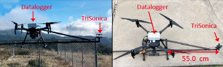
“This sensor is ideal for the UAS due to the output of magnetic heading and accelerometer corrections, as well as its small mass of only 50 grams,” Clements added. “The really cool thing about the TriSonica Mini is it autocorrects; it has got an inertial measurement unit (IMU) so it automatically corrects for pitch and roll. That’s huge!”
During this research, the FWRL was able to measure the meteorology and turbulence associated with a fire front, providing a high-quality dataset for understanding fire behavior, including the rate of fire spread and smoke dispersion guidance. The drone enables the FWRL to easily capture the evolution of the wind field close to the fire front “without completely destroying a bunch of instruments” - something that normally doesn’t happen using traditional methods such as balloons or towers/tethersondes. Moreover, UAS based sounding systems may prove to be more cost-effective and user-friendly than radiosonde systems for fire weather monitoring and observations, as they reduce costs associated with balloons, sondes, and helium, and its assembly and launch take around 10–15 minutes at any height and location.
“Balloons can be very effective at giving us temperature and wind profiles,” Clements said. “But balloons are cumbersome because you’re dealing with the balloon, helium, a tether line, a winch, all so that you can put a balloon up in the atmosphere with a sensor package on it. While this is how we conducted repetitive wind profiles in the past, it just doesn’t work in an active fire zone. Unmanned aircraft systems (UAS) are proving to be a reliable and easily deployable research platform for scientists conducting meteorological profiling in a fire environment. They have demonstrated themselves to be both economical and effective.”
However, with errors of 1 ms−1 or more being common with this platform, the FWRL believes it is useful for atmospheric soundings and weather station-like observations, but not for directly quantifying fire–atmosphere interactions. Further research is needed to better understand UAS operations in the operational environment during active wildfire suppression activities. Additionally, more field testing is required to test other various aspects of the platform, such as comparisons of the system’s vertical profiles against other vertical profiling technologies, such as tethersondes, radiosondes, or sodar and lidar.
“Currently, we're the only metrological team in the US that can deploy to active wildfires,” Clements said. “We’re listed as a national resource, so we can be called upon at any time. I envision one day that we would deploy all of our assets: our two trucks (one with the radar, one with the LIDAR), our weather balloon system, our surface weather system, and our drones to compile a complete picture of the wildfire environment.”
As seen with the sheer amount of use cases out there, drones have repeatedly proven to be efficient, as well as cost- and time-saving tools in fire & rescue (and other industries). Recently, we published an article regarding four innovative use cases for drones in fire & rescue, and we’re always looking for new, innovative ways for drones to help within public safety and emergency services.


Comments