

For the first time, unmanned aerial systems (UAS) and holograms helped to fight wildfires. Drones from Boeing’s subsidiary Insitu and the Microsoft HoloLens are the new tools used to make fighting forest fires a lot safer for firefighters.
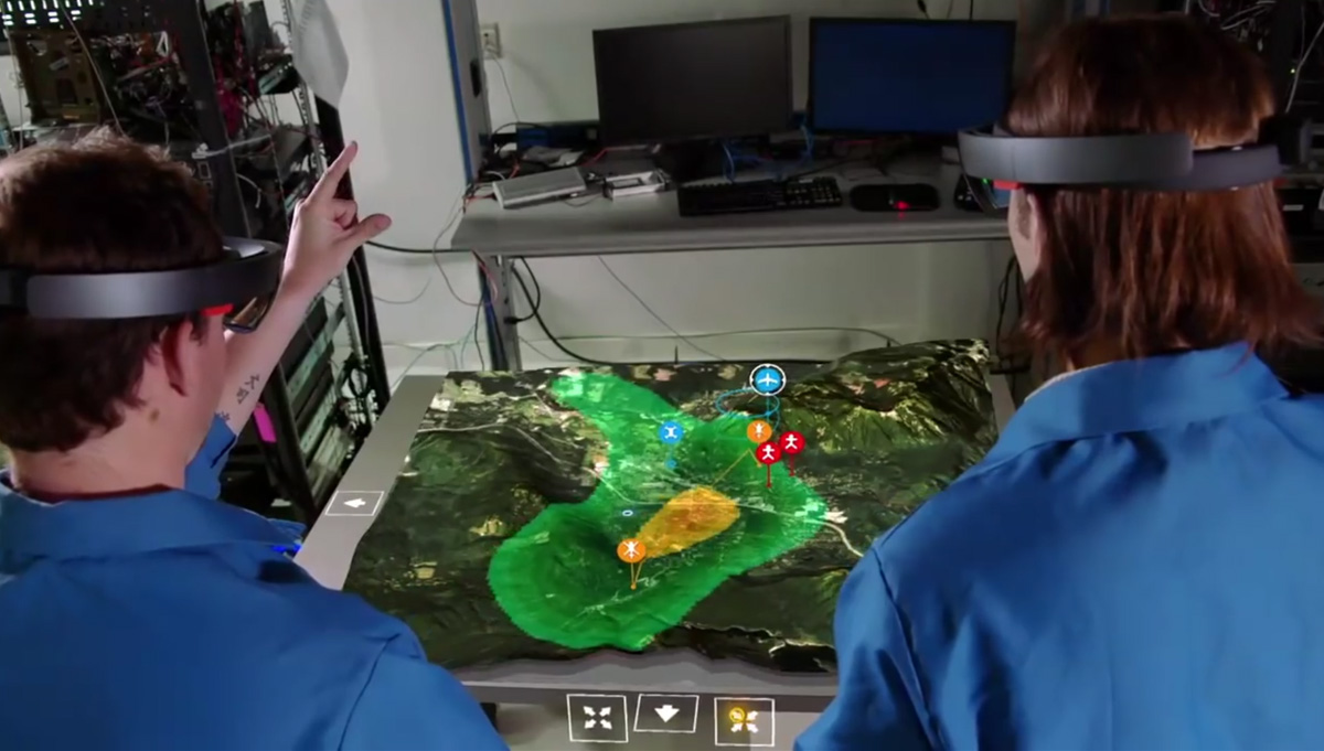
Mix a large drone as the ScanEagle from Insitu with the Microsoft HoloLens and suddenly you’ve holographic tactical maps that operators can manipulate to direct resources to where they’re most needed. It looks like a science-fiction story but it’s real, although we’re still starting to see the potential of the whole system.The third element of this story is the Inexa Control software, which represents the commercial version of Insitu’s ICOMC2 control system. The software’s 2D maps are the source used by the system to create 3D maps allowing operators to control all aspects of the operations. The advantages of the system were demonstrated May this year, at the AUVSI’s XPONENTIAL conference.May this year, simultaneously with the conference, Insitu announced the formation of a new commercial business unit within its corporate structure. The commercial unit aims to leverage the company's twenty-plus years of experience in unmanned systems to deliver unprecedented value to the emerging unmanned commercial aerial data collection market."Through our work in sectors such as energy, firefighting and railway monitoring, we have learned that these industries are looking to us as a trusted advisor," said Insitu President and CEO Ryan M. Hartman. "Insitu brings both the technology to assist companies with their information collection and processing needs and the experience gained through more than 20 years as a professional aviation company. Unmanned systems offer tremendous promise for industry, and Insitu's mission is to ensure that these technologies are employed in the most professional and safe manner possible to minimize risk and maximize our customers' return on investment."The video published by Boeing explains how the system works. Greer Carper, ICOMC2 product manager at Insitu, talks about the advantages of the use of UAVs in wildfires. Things like the use of infrared on the ScanEagle drones, he says, “we may see areas we do not think are on fire that actually are. This provides more situation awareness, so that better decisions can be made”. The video shows how the use of an interactive augmented reality overlay of a real-world wildfire scenario complete with a 3D map allows multiple users to see how the situation develops on the theater of operations.While we’re still beginning to understand the potential of the system, its use has already showed how important it is to make easier to make decisions and share information with large groups of people. Greer Carper says that with Inexa Control software, the engineers hope to use mixed reality technology to one day control an entire fleet of UAVs for commercial use.The experience with Microsoft HoloLens is a new chapter for Insitu in terms of fighting wildfires, but its ScanEagle drone has been deployed before, as early as 2014, in Australia. The demonstration took place in January that year, over the Wollemi National Park, 150 km northwest of Sydney, where fires have burned more than 35,000 hectares of bushland since December 2013. Insitu Pacific successfully demonstrated the operational utility of ScanEagle to monitor and report on the movement of the fire front at night – a task rarely undertaken at low altitude by manned aircraft due to the high risk factors involved. The success of the trial is attributed to a collaborative effort between Insitu Pacific and General Dynamics Mediaware. Insitu Pacific employed General Dynamics Mediaware’s next-generation video exploitation system, D-VEX, to stream full-motion video imagery alongside geo-location information in near real time. Fire commanders used the imagery to assess the movement of the fire front and pinpoint the locations of high-risk spot fires well ahead of the front itself. As a result, response assets were mobilized more quickly and safely, because their position relative to the location and movement of the fire could be actively monitored from the emergency services headquarters.“This technology is a game changer for emergency services and first responders,” said Insitu Pacific Managing Director Andrew Duggan. “We have proven systems that offer substantial capability advantages in this domain and will also enhance the safety of the personnel responding to an emergency. This event was a great success and the main objective now is to continue to work with CASA (Civil Aviation Safety Authority) to enable flexible airspace approvals for various emergency response scenarios.”In the United States, the ScanEagle was first deployed in the Summer of 2015. While more than 625,000 acres of wildfires burned throughout the Pacific Northwest, crew members of the Insitu Rapid Response team launched a ScanEagle unmanned aircraft into the hazy skies above the Paradise Fire in Washington’s Olympic National Park.The event marked the beginning of an operational demonstration designed to show how unmanned aircraft technology can be a powerful force multiplier in the fight against wildfires.ScanEagle flew six operations, delivering more than 37 hours of infrared video in real time to Incident Command personnel. Insitu’s suite of motion imagery software provided enhanced video and geo-registration capabilities that enabled fire officials to pinpoint the fire’s perimeter and identify areas of intense heat. ScanEagle also assisted helicopter assets with evaluating water drop locations.
 “This and other planned unmanned aircraft systems demonstrations will serve to guide our policies, procedures and requirements for the safe, phased integration of UAS in support of wildfire management,” said Mark Bathrick, Director, Department of the Interior, Office of Aviation Services. “These demonstrations are part of a larger interagency strategy aimed at employing UAS to provide firefighters on the ground with time-sensitive information that will give them the highest level of situational awareness and support possible.”“We are honored to support the individuals who are risking their lives to protect the natural resources endangered by wildfires in the Pacific Northwest,” said Insitu President and CEO Ryan M. Hartman. “This exercise demonstrated our ability to collect, process and deliver information that helps fire officials achieve better outcomes.”ScanEagle flew within an emergency certificate of authorization (ECOA) issued to the Department of Interior from the FAA that permitted its operation within the confines of the temporary flight restriction. The ScanEagle is the industry-leading UAS that invented and continues to define the agile ISR (Intelligence, Surveillance, Reconnaissance) category. It’s a drone fit to different missions: Search and Rescue, Disaster Response, Force Protection, Combined Arms, Target Following, Battle Damage Assessment, Pattern of Life, Border Security, Asset Protection, Wildlife Monitoring, Agricultural Assessment, Communications Relay, Networked Operations, Anti-Piracy or Fire Fighting.


Comments