

One of the great advantages of uncrewed aircraft is precisely the fact that they do not carry humans on board and therefore are ideally suited for dangerous tasks. One of the most dangerous and safety-conscious industries in the world is mining, and, as such, they have been pioneers in the early adoption of autonomous vehicles in all their forms.
Open pit mines are particularly heavy users of land surveying and therefore prime candidates for the adoption of techniques that do not expose humans to the dangers of large machinery and unstable ground.
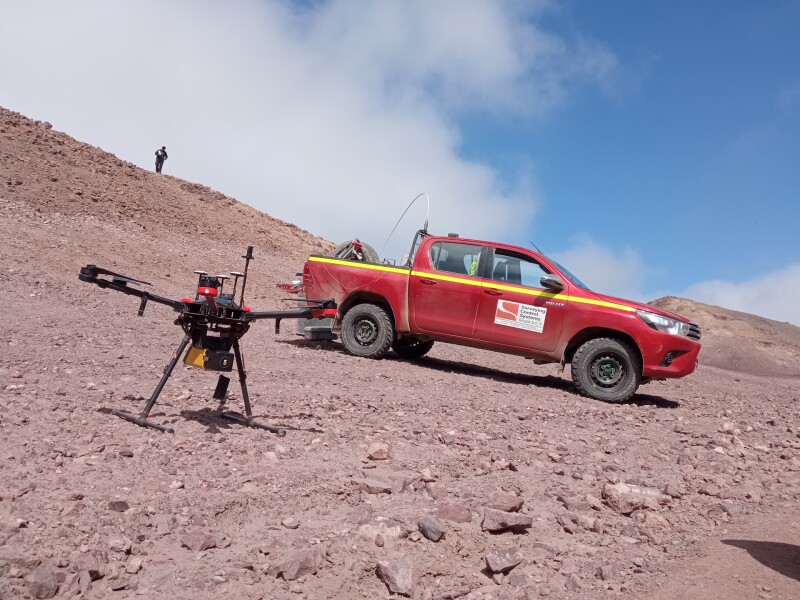
Dusan Domancic, Deputy General Manager of Surveying Control Systems, a Chilean company that specializes in servicing the enormous mining industry in this beautiful southern country gave us an exclusive interview to review how drones have changed the way land surveyors do their work around the extreme safety measures in a mine.
“The need for land surveying services in a mine are not only enormous but constant,” Domancic said. “Not only the need for in-site monitoring and development, but also for new projects and expansion into adjacent areas.”
The bulk of copper mining in Chile, the #1 producer and exporter of copper in the world, is done in the Atacama desert, the driest area on the planet at an average altitude of 13,000 ft. This combination of factors presents a unique set of challenges to land surveyors who are required to perform their duties under extreme safety measures.
“We are involved mainly in the areas of mining operations and development of new projects within these mines,” said Domancic. “These mining companies are constantly optimizing their processes to reduce the environmental impact and one of the most important areas is the absence of water in the desert. This requires sending desalinated water from the coast and that requires hundreds of miles of new aqueducts. These projects can go from mean sea level to 13,000 ft and extend for 120 miles in the harshest conditions on the planet and the safety requirements are not relaxed even for a minute.”
These safety requirements which include hard hats and high-visibility vests at all times, including inside vehicles, impose a heavy financial toll in contractors and sub-contractors who are required to invest vast amounts of money into safety courses and constant briefings.
“That’s why when we had the opportunity to perform some of our land surveying tasks with drones, we jumped at the opportunity and the mining companies loved it!” Domancic said enthusiastically. “We could map large swaths of land using drones and with very little involvement from ground land surveyors, diminishing our exposure and increasing our productivity while complying with the mine’s safety requirements.”
The Atacama Desert presents a unique challenge to traditional cartographers because the differences in ground color and contrast are so minute that conventional cameras have a hard time capturing the necessary level of details for technicians in the office to determine elevation and contour lines.
“One day we switched to LiDAR technology, and we haven’t looked back ever since,” Domancic said. “With LiDAR we can map long extensions of future corridors and exploration areas in a few hours and the processing and analysis is safe and trustworthy. We can create better maps faster and at a fraction of the cost, surprising even the most incredulous customer. This product will serve our clients better than a traditional map and provides them with a precise, georeferenced point cloud that can be used to launch new projects, faster.”
In this new world of heavy competition and smaller profit margins, every competitive advantage helps. Uncrewed aviation and airborne LiDAR have come just in time to turn these traditional surveying concerns into modern aviation enterprises, helping the mining community expand without sacrificing safety or speed.


Comments