The information you submit will be stored and used to communicate with you about your interest in Commercial UAV News. To understand more about how we use and store information, please refer to our privacy policy.
Recognized as the successful commercial developer of the Overhauser, optically pumped Potassium (K-Mag) and Proton Precession magnetometers, GEM Systems supplies magnetometers, gradiometers and magnetic sensors for Earth Science, Geophysics and other applications. Their three decades in the research and development of equipment for geophysical exploration have provided professionals in these areas with the tools they need to capture incredibly detailed and precise information.
Used to perform magnetic surveys to record spatial variation in the Earth's magnetic field, magnetometers and gradiometers are important tools for various applications. These include Airborne Mapping, to target ferrous deposits; Archaeology, to detect artifacts and cultural objects, as well as underground structures; Mineral and Oil Exploration; Observatories to accurately and continuously measure the Earth’s magnetic field, Unexploded Ordnance Detection (UXO) to find potentially dangerous munitions of all sizes that remain buried in the earth from wars; and others.As a pioneer in the development of airborne (manned aircraft), ground, and stationary magnetometers, GEM Systems wasn’t blind to the fast-growing drone industry. That’s something Shawn Kovacs, Ph.D., Geoscientist, Sales and Marketing Manager at GEM Systems, was able to talk through in great detail.“Given the increase in popularity of UAV platforms as a result of usability, minimal area for take-off/landing, payload capacity and autonomous capabilities, GEM Systems has specifically designed a lightweight and ultra-sensitive magnetometer (DRONEmag) in addition to turnkey solutions like the AirBIRD and AirGRAD for UAV applications.”
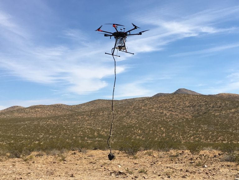
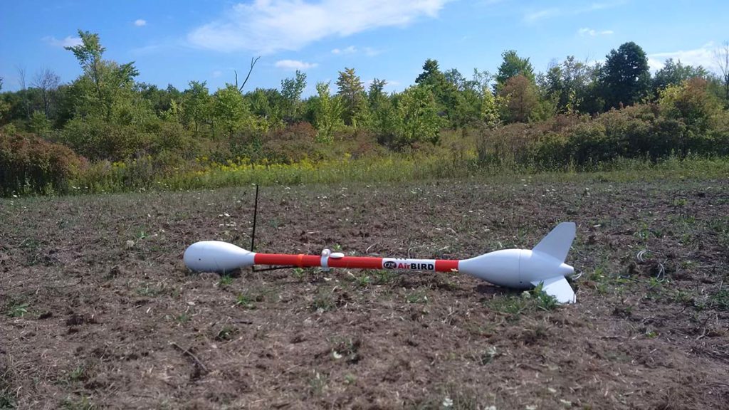
UAV Solutions for magnetometer and gradiometer surveysToday, GEM’s DRONEmag™ is one of few quantum magnetometers developed specifically for drone magnetometer surveys. Powered by GEM’s Potassium technology of optically pumped magnetometers and gradiometers, the DRONEmag and is an ultra lightweight potassium magnetometer (less than 1.8 kg), which easily attaches to a drone with a sling, and “offers the highest sensitivity, absolute accuracy and gradient tolerance available in the industry”. There are two DRONEmag’s modifications available: one that facilitates recording the rich data stream from Pixhawk autopilot, and another that integrates GPS, laser altimeter, IMU and data radio-link.To provide professionals with a more complete package, GEM offers two complete UAV solutions for high precision magnetometer and gradiometer surveys, the AirBIRD & AirGRAD UAV Systems.Weighing 3.6 kg only, the AirBIRD is suitable for medium and larger quadcopters and helicopter UAVs, at a recommended minimum airspeed of 10 m/s. It provides high-quality magnetic data, records and stores additional flight parameters (Altitude, GPS location, Pitch, Roll, Yaw, and Satellite), which transmit in real-time to a ground station. The information is then displayed with GEMDAS, the company’s custom data acquisition software featuring Multi-Window display of mag data and flight parameters, 3D Graphic Attitude display, and Integration with Google Earth.The system simply attaches to an appropriate UAV for immediate survey operations.At a weight of 8.5 kg, the AirGRAD solution is a light-weight vertical gradiometer that “includes two high sensitivity ultra light-weight magnetometers, plus all of the components required for a precise UAV gradiometer survey”.Both solutions are available as a standalone instrument, or complete with an appropriate UAV.The Monarch, a Fixed Wing UAV used for gradiometer surveys, utilizes two GSMP 35U high sensitivity magnetometers to provide gradient survey capability. It requires a short take-off and landing area and flies at 70 km per hour for 1-hour flights. UAV vs Traditional method surveys When comparing UAV and Traditional method surveys, one needs to take into consideration two subcategories: UAV vs Ground and UAV vs Airborne surveys.In relation to UAV vs Ground Surveys, according to GEM Systems, while an operator takes 10 days to survey a 100 kilometers line, drones perform the exact same task in only one day, greatly reducing costs and increasing operator’s safety. Additionally, although the magnetic signal is slightly reduced when using a drone, due to its altitude difference, the density of the collected data results in a far more detailed DRONEmag image “that truly changes the impact of magnetometer data”. Drone magnetometer surveys also minimize noise from operator movements which are encountered in ground surveys.On the other hand, UAV surveys remove many of the difficulties posed by Airborne (manned aircraft) ones. Due to safety restrictions, aircraft fly at a minimum height of 300 feet, while UAV magnetometer surveys are flown at 100 feet, resulting in a much stronger and higher quality signal. In addition, drone magnetometers are easier to launch, mobilize, set up and re-energize, and can fly in most weather and at night.“With 10m line spacing and high sensitivity, DRONEmag creates a level of information not yet seen in the exploration world. This kind of detail leads directly to new understanding and discoveries,” GEM Systems claims. Showcasing the technologyLater this year, at the Commercial UAV Expo on October 1-3, “attendees will be able to take a close look at the DRONEmag™, AirBIRD and AirGRAD. Surveyors who want to complete the job with the best equipment available on the market will be able to go hands-on with these products to get a better understanding of exactly where and how they can be a fit for their workflows and projects,” Kovacs said.If you think GEM’s solutions work for you or your company, Kovacs tells you to “contact the knowledgeable GEM Systems staff immediately”.
Technology in general makes João Antunes tick, but the specific ways it has created and changed the landscape in IT, gaming and computers ignited curiosity that’s turned into a passion for him. As the son of a journalist writing about how these industries have emerged and evolved, he has an incredible perspective when it comes to understanding the kind of disruption new technologies can create in a given space. He’s committed to showcasing what that disruption will mean for professionals as they work to utilize brand new pieces of hardware, software, systems and processes.
Our Newsletter
Subscribe to our weekly global newsletter for news, insight and market information about commercial drones!


Comments