


The transformation of aerial photogrammetry over the past two decades has been nothing short of incredible. From large aircraft with two or three technicians on board and plastic film cameras weighing 50 or more lbs., to today’s uncrewed aircraft and digital cameras weighing just a few ounces. The promise of faster, cheaper, and more accurate aerial surveying has been realized. But now we face a new dilemma.
Improvements in sensor resolution, image storage capacity, and battery life are combining to create a brand-new problem: we are collecting too much data in each flight, and our capacity to analyze and make sense of it all is not moving at the same speed.
And here is where the controversial issue of Artificial Intelligence (AI) comes to play an important role in how we convert all these gigabytes of data into actionable information.
We searched far and wide for someone who would be able to shed some light in how AI is helping land surveyors to handle the deluge of data to help their customers make sense of it all. We found a company in Germany, Flypix AI, that specializes in the development of AI tools to help turn drone data into intelligence.
In an interview with Commercial UAV News, Dr. Sergey Sukhanov, CEO and co-founder of Flipix AI, talked candidly about their technology and how, without it, we will be spending more hours in the office trying to decipher patterns and trends.
“The idea is simple; we developed AI algorithms that look through georeferenced data and then detect and classify items according to the specifications of our customers,” said Sukhanov. “Now, is it easy? No, of course not. 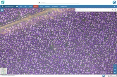 It took us years to build the right technology to use in the specific case of geospatial data and the requirements of the end-user of the information.”
The uses for this technology are endless, and so far, Flypix is receiving a huge number of requests to support forestry management and provide calculation of biomass by classifying and counting trees. The other industry where Flypix is active is construction.
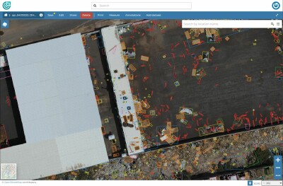
“Construction is one of those industries that is in desperate need of new technology, not particularly in the erecting of edifices per se, but in everything that surrounds a construction site,” Sukhanov said. “During execution of a large project, the site is a bit of a controlled chaos and therefore anything that helps bring order into it is welcome. Our technology can classify materials and very quickly inform management of the need to move, replace, or reposition materials, equipment, and personnel.”
This great example of a specific application took the conversation along the lines of what the future holds for Flypix technology and the need of many industries for automation of their classification flights.
 “We work with any georeferenced images, so the sensor could be mounted in a satellite, a drone or a crane; it makes no difference to the algorithms,” Sukhanov said. “We are helping companies identify loose fishing nets in the ocean, help logistics companies with handling of shipping containers in busy ports and in general fine tuning machine learning to help sift through enormous amounts of data that will take humans years to accomplish with traditional methods.”
There is no doubt that apart from the recent controversy with AI becoming too intrusive in our daily lives, this application and its awesome powers is bound to benefit humanity in general and companies in particular that need to classify large number of objects disseminated over considerable geographical extensions.


Comments