We’re so used to thinking of NASA in the context of space exploration that most of the time we forget that the federal agency is also responsible for advances in aeronautics. As their name suggests though, the National Aeronautics and Space Administration is very much focused on the science involved with the study and design of air flight-capable machines.
Over the past decade, NASA has partnered with industry and academia to advance the cause of unmanned aerial vehicles (UAV) and their eventual integration into the National Airspace (NAS). The inevitable addition of unmanned aircraft to the skies comes with plenty of complications, which range from onboard safety devices to modifications to existing air traffic control (ATC) protocols all the way to the
new science of unmanned traffic management (UTM). This incredible variety is why each of these elements has a specific initiative at NASA, although they are all part of the agency’s larger Integrated Aviation Systems Program (IASP).
The IASP conducts flight-oriented, system-level research but is also focused on technology development to effectively mature and transition advanced aeronautic technologies into future air vehicles and operational systems. The IASP focuses on the rigorous execution of highly complex flight tests and related experiments to support all phases of NASA’s aeronautics research. For technologies at low technology readiness levels, IASP flight research aims to accelerate development and determine feasibility. For more mature technologies, the IASP is designed to help to reduce potential risk and accelerate the transition to industry.
There are hundreds of initiatives aimed at helping advance this integration, but we’d like to mention the three that seem to have the greatest chance of becoming a reality. Tying back into the inherent complications that are associated with integrating drone technology into the airspace, one of these is tied to effectively onboarding safety devices, one is focused on the ground while the last one is centered on UTM.
- The Systems Integration and Operationalization (SIO)
SIO is a partnership between NASA and industry partners with the goal of accelerating routine UAV operations into the NAS. SIO will enable robust UAV operations into the NAS by leveraging integrated Detect and Avoid (DAA), Command and Control (C2), and state of the art vehicle technologies with a pathway toward certification to inform the FAA UAV integration policies and operational procedures.
DAA involves employing sensors of some type (such as radar or cameras) to sense if the aircraft is flying too close to an object (such as a tall building or another aircraft) and then takes steps to fly away from the potential danger. C2 involves technology that ensures the unmanned aircraft remains in constant, secure contact via radio with ground-based pilots and air traffic control. Crucially, it also allows the UAV to determine what to do on its own to stay safe in case that signal is lost.
NASA is partnering with Bell, General Atomics-ASI, and PAE ISR to perform SIO demonstration activities in the summer of 2020. These industry partners will lead the development, integration, testing, and certification of their UAS. NASA will support by providing consultation.
NASA will also work with their industry partners to tackle key challenges that prevent routine commercial UAV operations today, including development, integration, and certification of unmanned aircraft and its onboard systems.
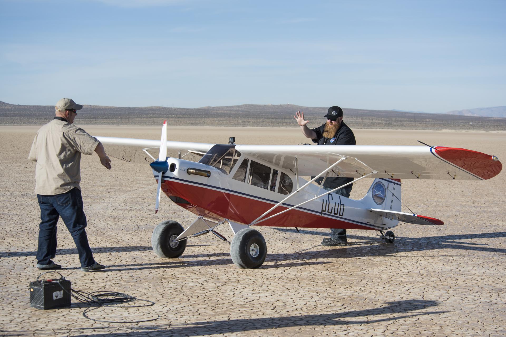
NASA's newest micro Cub platform for UAS research
- UTM Research
The Unmanned Aircraft Systems Traffic Management (UTM) research project is led by NASA’s Ames Research Center in California’s Silicon Valley. The project is in partnership with the Federal Aviation Administration along with other federal agencies and dozens of academic and commercial partners. A key feature of the project is the involvement of those other government agencies as well as the six field test sites of the FAA located in Alaska, Nevada, Texas, North Dakota, Virginia, and New York. NASA’s close collaboration with the FAA has allowed them to easily transfer results, recommendations, requirements and technology as they became ready, and will continue to influence how the FAA leverages this info.
The goal of the project is to study what it will take to make UAV operations – or drone flights – possible in low-altitude airspace in order to develop technologies, roles, responsibilities and procedures for a future airspace management system that safely manages autonomous aircraft operations over populated areas. The UTM project is testing those technologies through a series of field demonstrations called "Technical Capability Levels,” each more complex than the previous as different operational environments, software, procedures and policy requirements are demonstrated.
Technical Capability Level One was focused on field-testing rural UAV operations for agriculture, firefighting and infrastructure monitoring. It enabled UAV operators to file flight plans reserving airspace for their operations and provide situational awareness about other operations planned in the area.
Technical Capability Level Two demonstrated applications that operate beyond visual line of sight of the operator in sparsely populated areas. Researchers tested technologies that allowed dynamic adjustments to the availability of airspace and contingency management.
Technical Capability Level Three was conducted in 2018. It included cooperative and uncooperative UAV tracking capabilities to ensure collective safety of manned and unmanned operations over moderately populated areas.
As a part of NASA’s Airspace Operations and Safety Program, the UTM project’s goals are aligned with one of NASA Aeronautics’ six major research thrusts. This thrust calls for enabling utilization of higher levels of automation and autonomy across the aviation system, including a routine UAV presence in the NAS.
UTM combines the onboard hazard avoidance software in the UAVs along with a network of data providing dynamic geofencing, severe weather and wind avoidance, congestion management, terrain avoidance, route planning and re-routing, separation management, sequencing and spacing, and contingency management. As with ADS-B, the UAVs would share their location through the UTM to help provide separation
In the past few weeks, NASA has launched the final stage of a four-year effort to develop a national traffic management system for drones, testing them in cities for the first time beyond the operator’s line of sight as businesses look in the future to unleash the unmanned devices in droves above busy streets and buildings.
Multiple drones took to the air at the same time above downtown Reno on May 23
rd in a series of simulations testing emerging technology that someday will be used to manage hundreds of thousands of small unmanned commercial aircraft delivering packages, pizzas and medical supplies.
“This activity is the latest and most technical challenge we have done with unmanned aerial systems,” said David Korsmeyer, associate director of research and technology at NASA’s Ames Research Center in Mountain View, California. NASA had tested the UTM in rural locations but this was the first opportunity to see how it worked in an urban environment, where the potential conflicts are greater and the challenges of controlling the UAV's path among buildings and other obstructions are significantly greater.
Prior to the latest test in Reno, NASA described the mission: “Certified drone pilots will operate the aircraft in controlled areas of the city that are blocked to vehicle and foot traffic. The flights will simulate different scenarios involving multiple drones flying at once above city streets and between buildings. The researchers will collect data from the aircraft, drone pilots and commercial partners about the operation of the UTM system.”
Chris Walach, executive director of the Nevada Institute of Autonomous Systems, which is running the Reno tests, told The Associated Press that “when we began this project four years ago, many of us wouldn’t have thought we’d be standing here today flying UAVs with advanced drone systems off high-rise buildings.”
NASA says the Reno test was a success, and that this phase of the four-year program will continue in Reno and Corpus Christi, Texas, through the summer.
- Detect and Avoid System
NASA initiated a series of flight tests back in 2012 to assist the FAA as they developed regulations to allow the integration of UAVs into the NAS. Flash forward to today, and we find that their team has begun its final series of test flights for the project. Known as Flight Test Series 6 (FT6), these tests are taking place at NASA Armstrong Flight Research Center in California. The UAS Integration in the NAS project is managing the three-month long flight tests that are scheduled between September and November 2019.
FT6 will focus on low size weight and power (SWaP) sensors for DAA operations in controlled airspace to inform the FAA through the RTCA Special Committee DAA Working Group on the phase 2 minimum operational performance standards for DAA and air-to-air radar. FT6 will use the TigerShark Block 3 XP, a NAVMAR Applied Sciences Corporation (NASC), Group 3 UAV with a wingspan of 21.9 feet for the final test series. The TigerShark features a payload capacity of 95 lbs. and a maximum endurance of 12 hours.
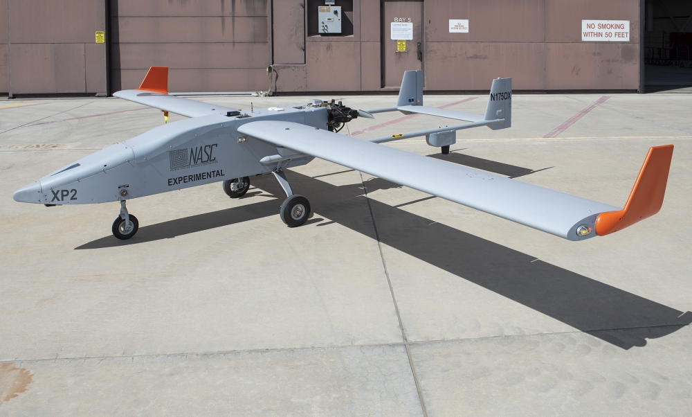
NASC TigerShark UAV
NASC personnel traveled across the country to deliver the TigerShark with a Mobile Operations Center, which includes the ground cockpit, to Armstrong May 6 from their facility in Pennsylvania.The TigerShark XP has been modified with a unique smoke system to help intruder aircrew visually acquire the aircraft during flight tests and a nose structure to integrate Honeywell’s radar system. The Digital Active Phased Array, or DAPA-Lite radar system, is a new technology compared to previous flight series.
The state-of-the-art radar system consists of three small radar panels whose radar beams can be electronically steered to point in different directions without the need of moving antennas. The three panels are arranged to provide a wide horizontal field of view.
“The radar system is cutting-edge technology with panels small enough to be carried on a smaller UAS, but still have enough range to see and avoid other aircraft,” said FT6 DAA Principal Investigator Michael Vincent. “Our goal for FT6 is to challenge the effectiveness of our DAA system and Honeywell’s radar system as we develop performance standards of unmanned aircraft being integrated in our national airspace system.”A primary objective for the project team is to characterize Honeywell’s DAPA-Lite radar to determine its effectiveness and its range and accuracy. The team will be testing what the radar can actually detect with its low size weight and power radar system. The DAPA-Lite radar will provide the data to the DAA system to determine the distance, bearing and elevation between the UAS and other aircraft. The DAA system will then use the information from the radar system to determine which flight path to take to maintain safe separation.
FT6 will also help to establish the minimum operational performance standards for DAA systems for UAVs in the NAS. The system must alert the pilot in a timely manner when a conflict occurs and determine which display elements the pilot needs to be aware of in order to guide the TigerShark away from potential danger. Three intruders (the
King Air B200,
T-34C and TG-14 Motor Glider) will be used during the flight tests each representing a different common size aircraft that a UAS may encounter in the NAS.
Some flight tests will require an intruder aircraft to fly on the same path head-on toward the TigerShark with a safety separation buffer. This particular encounter will demonstrate the effectiveness of the DAA alerting system and what type of guidance it will recommend to avoid the intruder.
The flight series includes 150 encounters in 26 flights, which consists of six radar characterization flights, 12 DAA scripted encounter flights and eight full mission encounter flights. Each full mission encounter flight will feature a different pilot that is naïve to the FT6 objectives and encounters to gather accurate data on how a pilot will react and respond to the systems. Pilots will fly a simulated UAS mission and interact with an air traffic controller and other traffic (live and virtual) in the airspace. The pilot will be tasked with using the DAA system to avoid live aircraft that the DAPA-Lite radar detects.
“Every decision we have made for FT6 was a result of what we have learned in previous flight tests,” added Vincent. “Our journey through each flight test series has been instrumental in the hopes of allowing unmanned aircraft to enter unsegregated airspace in the near future. FT6 will be a big factor on how we can safely integrate unmanned aircraft.”NASA’s participation includes Armstrong, and researchers from Ames Research Center in California, and Langley Research Center in Virginia.
These three distinct but connected initiatives are all aimed at ensuring that UAVs will be safely and securely added to the NAS without adding undue danger to the flying public and maintaining the current level of safety of the ATC. It is reassuring to know that NASA the FAA, academia and private industry are working together to make this
inevitable integration possible in the safest and most expeditious manner.


Comments