


Civil Infrastructure
 Drones fly at Red Rocks AmphitheaterAlthough drones are not allowed to fly at Red Rocks Amphitheater and Park, a special permit was issued to allow a team consisting of the engineering firm Kimley-Horn, software maker Autodesk and drone manufacturer 3D Robotics (3DR) to fly drones over the unique concert hall. The park, which was recently named a National Historic Landmark by the National Park Service, is now preserved for posterity in digital form.The group set out to capture the entire park using drones with a new streamlined workflow, and were able to provide the park with orthoimagery, oblique imagery and a 3D model. This data can be used as a historical archive as well as to guide management practices. “Denver Parks and Recreation are interested in the model for lighting and sound design for the concerts that take place there,” says Bobby Valentine, firmwide project visualization lead, Kimley-Horn. “They’re also thinking about paving several parking lots to reduce erosion, and the model will be very useful to understand water runoff and plan for stormwater management. The model will also assist trail maintenance and facility management.”
  Drones for inspection of bridgesThe use of drones for inspection of bridges could eliminate the need for lane closures and cut inspection costs by 30 percent. That’s what the Delaware River and Bay Authority suggested in April this year, when they tested drones to inspect the Delaware Memorial Bridge. They are not alone: Connecticut and Minnesota are a couple of the many states looking to understand how viable drones are when it comes to bridge inspections.The Ohio Turnpike and Infrastructure Commission is also exploring the potential of the use of drones in sections of the Ohio Turnpike, a 241-mile toll road offering one of the safest, best and most convenient routes for motorists to reach east/west destinations along the northern corridor of Ohio. They will have the first inspections this September, centered on the Sandusky River Bridge, which is 970 feet long and represents a difficult task to inspect in traditional ways. The results from that first inspection will determine if drones will become a regular part of the landscape on Turnpike. Read the whole articles following the relevant links.
  DJI drone inspects 1000 kilometers highwayMexico’s public government decision to use a DJI drone to accomplish the biggest drone-mapping project in history confirms how fast drones are changing the way cities maintain and build infrastructure. A company, Skylab Industries, uses a DJI drone and DroneDeploy software to create a high-resolution map of a large section of highway – 1000 kilometers.The government needed to evaluate the existing highway system to prioritize its maintenance and reconstruction. A high-resolution map allows the government to inspect pavement conditions, lane markings, and vegetation encroachment. This information is crucial for the government to prioritize and streamline the infrastructure improvement process. The company completed the task in just three weeks, processing 114,043 images, creating 869 orthomosaic maps, and producing 2,607 models. In the end, they provided 8.0 terabytes of high-resolution highway data to the Mexican government on time.
  A drone hovering above your streetWhile there's a tendency to associate drones with big projects in multiple areas or as part of an all-encompassing initiative, but they can be used to help deal with and resolve issues that are far more basic. The city of Abilene, in Texas, has a new project that, if it works, will put drones hovering the head of their inhabitants. The flying eye in the sky is used to… inspect the pavement! Yes, Abilene is working in conjunction with independent contractors to obtain aerial survey information of certain downtown Abilene streets for the purpose of planning a street repair project.A drone, equipped with a camera and weighing about 2 pounds, recently flew over some streets in Abilene, photographing them at a reasonable altitude above any obstructions and within the confines of the specified streets themselves. Inhabitants were asked to remove their cars from the streets and to stay inside for the 15 minutes period of the inspection flight in each street, for safety reasons. If the results are favorable, we may well see drones helping contribute to the faster repair of cracks on the pavement.
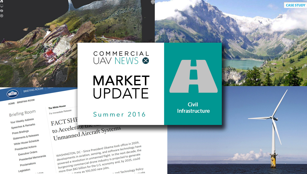
  Drone inspects mountain damThe Tseuzier dam, in the mountainous Swiss canton of Valais, sits at an altitude of 1,800 meters (5,905 ft) above sea level. It's the sixth tallest in Switzerland, measuring 156 meters (512 feet) at its highest point. Its operator, Electricité de la Lienne, needed to have a record of the structure’s downstream face, and contacted SenseFly to do the inspection.Two weeks of flying in difficult conditions, with rapid weather changes, allowed the team not only to supply 7000 high-resolution photos, 4 high-resolution orthophotos and the relevant information about the structure, to be used as part of its five-yearly inspection report for the country’s energy regulator, but also to confirm the ability of their drone, Albris, to provide full photographic coverage of a large dam. Follow the link to read the complete Case Study published by SenseFly.
  White House accelerates integration of dronesWith new legislation in place, the White House is preparing to accelerate the safe integration of unmanned aircraft systems. In a document published in August 2016, the White House Office of Science and Technology Policy (OSTP) announced new steps, sustained by public and private support, to promote the safe integration and innovative adoption of unmanned aircraft systems across the United States.Amidst the multiple key actions announced is one related to “$35 million in research funding by the National Science Foundation (NSF) over the next five years to accelerate the understanding of how to intelligently and effectively design, control, and apply UAS to beneficial applications." This will include areas such as monitoring and inspection of physical infrastructure, smart disaster response, agricultural monitoring, the study of severe storms, and more. Additionally, it will mean the protection of endangered species and habitats, delivery operations that will increase accessibility to remote communities, suppression of wildfires and enhanced emergency response operations. Follow the link to read the whole document as well as an exclusive interview with a policy advisor.
  Department of Interior buys 40 3DR dronesThe Department of the Interior awarded 3DR with a contract to deliver up to 40 of the company’s Solo quadcopters that will be made available for use by different agencies. That will include the Bureau of Land Management, the National Park Service, the Office of Surface Mining Reclamation and Enforcement, the U.S. Fish and Wildlife Service, and the U.S. Geological Survey among others.“The contract is extremely important to the Department, as it will allow us to conduct many missions that were previously impossible due to limited resources and costs associated with using manned aircraft,” said Harry Humbert, deputy assistant secretary for public safety, resource protection and emergency services. Read the whole story by following the link. Drones control drivers in IndiaThe Maharashtra government ordered the use of drones to monitor traffic on one of the most dangerous roads in India, the Pune-Mumbai Expressway, leading to the first fines to drivers based on aerial pictures showing the drivers cutting lanes.Maharashtra Minister of State for Home (Urban) Deepak Kesarkar said that “Incidents of road accidents have increased due to the indiscipline of vehicles and their rash driving. We do not have control over rash driving as the length of the expressway is long and there is insufficient police staff for surveillance”. Drones were introduced for testing because using CCTV cameras for the purpose has its own limitations, added Kesarkar. Read the whole article following the link.
  Offshore wind energy and dronesThe U.S. offshore wind energy industry is taking its very first steps and Todd Sumner believe that drones can play an important role in that future. In one article published at The Drone Girl, the author writes that “from pre-construction surveys, minimizing risk liability for compliance with the Endangered Species Act and Marine Mammal Protection Act to post-construction operation and maintenance inspections, the incorporation of drones will allow for a safer, more efficient undertaking of activities and tasks to help protect a project’s bottom line and ultimately the marketability of its wind energy product.”The article focuses on other aspects of the civil infrastructure industry where the integration of drones will make sense, and states that “as far as operation and maintenance, drones already have a positive track record for conducting inspections of land-based critical infrastructure including railroads, pipelines, bridges, cell towers and on-shore wind farms, allowing a more efficient and strategic assessment of operation and maintenance needs without risking human safety.” Follow the link to read the whole article.
.jpg.small.400x400.jpg)


Comments