
In order for regulators throughout the world to allow for the full integration of manned and unmanned aircraft in controlled airspace, a few technologies and procedures need to be perfected and fine tuned to work with each other seamlessly. One of these technologies is known as an unmanned traffic management (UTM) system, and there will be no integration of the skies without a solid implementation of it. Europe has launched a comprehensive initiative, known as U-Space, to implement pan-European UTM standards and protocols that would allow private industry to compete in providing UTM services in every country throughout the EU.
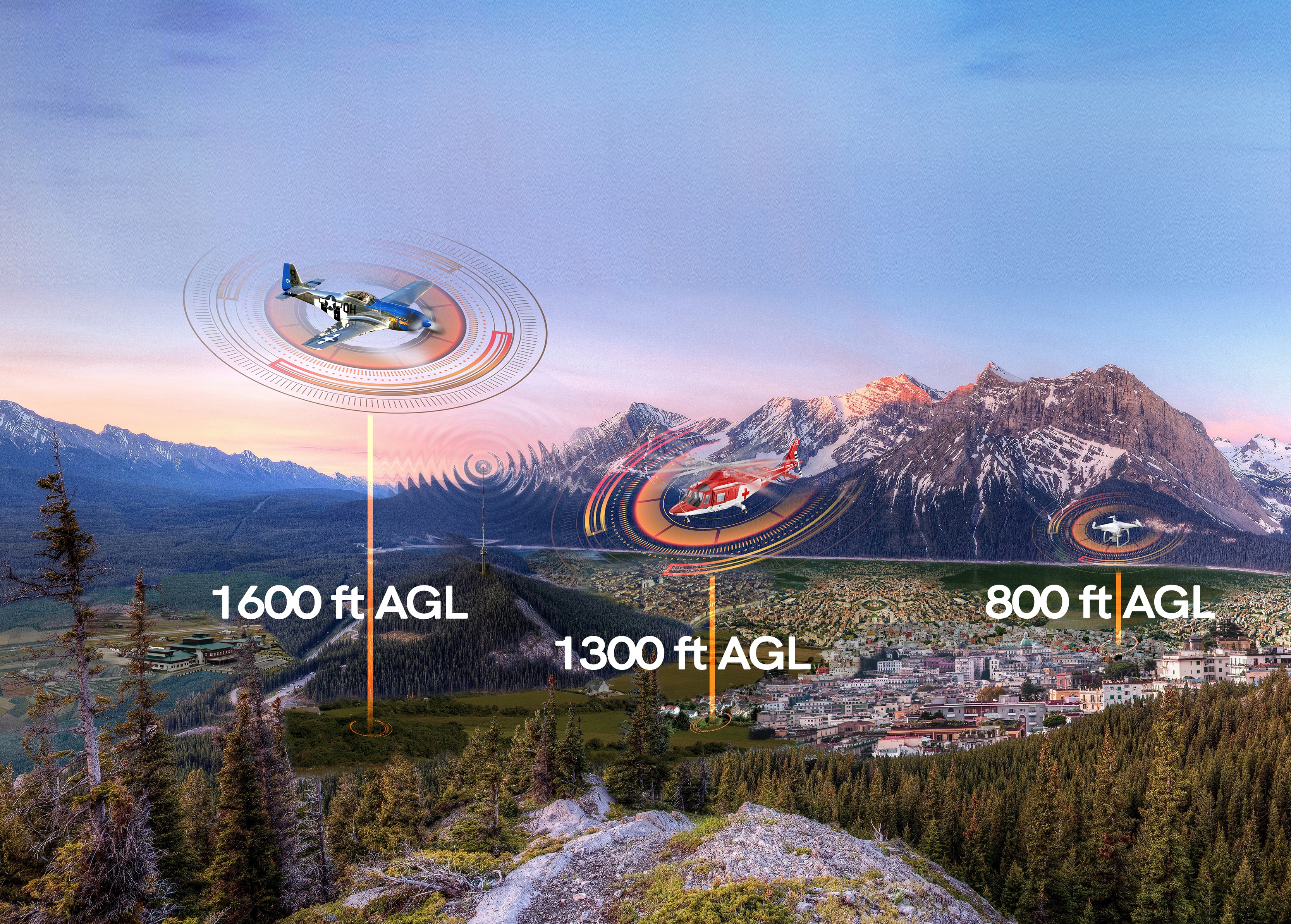
During the recent Commercial UAV Expo Europe we came across INVOLI, a Swiss company which is promoting the idea that the key to a solid UTM implementation is the data that would feed the system, allowing pilots of manned and unmanned aircraft as well as ATC (air traffic control) to make decisions and seamlessly work together to complete their flights safely. In a very educational conversation in their booth, we had the opportunity to talk to Mélanie Guittet, co-founder and Manager of Business Development, Cristina Mihalachioiu, co-founder and Manager for Legal and Communications and Manu Lubrano, co-founder and CEO.I asked Cristina what made INVOLI different from all the other UTM companies in the exhibition floor advertising their products; she got closer to me and whispered: “We are the missing link.”“Our system is called involi.live and what we do is that we collect real time LAATD (Low Altitude Air Traffic Data) from ADS-B (Automatic Dependent Surveillance & Broadcast) and aircraft transponders, process it and transmit it to the UTM system so anyone flying and connected to the system can have that information onboard in real time," Mélanie told Commercial UAV News.“The main issue with UTM implementations is that most UAVs fly at very low altitude, below 2,000 ft AGL (above ground level), and at that altitude radar service is not available so manned aircraft operating at those levels, either descending for landing, taking off or helicopters operating in that band are susceptible to blind spots due to the lack of radar cover," Manu mentioned.“The secret to involi.live is that we collect all this data from flying aircraft with our own sensors and in milliseconds, process it and transmit it to the various manned and unmanned aircraft operating in the area and pilots have real-time information about approaching aircraft," Cristina said enthusiastically.“With our graphic geofencing tools, pilots can quickly determine the nature of the potential danger in approaching aircraft and make a decision if to continue the flight or take evasive action," said Mélanie.“The same applies to the autonomous unmanned aircraft receiving the data via the existing 4G network; the onboard controller has all the information to calculate if it needs to take evasive action or to continue the flight. The system also provides no-fly zones that the on-board controller uses to create safe flying corridors in real time; involi.live should work in coordination with the UAV’s own detect and avoid system to create redundancy and enhance security," Cristina told us.Manu Lubrano made emphasis that a solid telecommunications’ infrastructure was essential to make the system work and mentioned that INVOLI already has a great partnership with Swisscom, a major telecommunications provider in Switzerland, to constantly improve the symbiotic relationship between the collecting and processing of the data and the transmission of it through their network.With as many as 15 awards received in its short corporate life, INVOLI seems to be well positioned to be a key player in the inevitable integration of manned and unmanned aircraft in controlled airspace in Europe.Subscribe
The information you submit will be stored and used to communicate with you about your interest in Commercial UAV News. To understand more about how we use and store information, please refer to our privacy policy.
May 2, 2018
INVOLI, the Missing Link in the Implementation of an Effective UTM

Want more stories like this? Subscribe today!


Juan received a degree in Geodesy and a master in digital photogrammetry from Universidad Central de Venezuela and a MBA in international Finance from Florida International University. He has over 750 hours of experience in photogrammetry navigation and camera operation in aircraft as varied as WWII B-25, Cessna 310, Lear Jet 25C and Piper Aztec. Juan holds a Commercial, Multi-engine Pilot certificate. Juan has been selling mapping UAV’s in Latin America for four years and is a frequent guest speaker in events where the safety of flying UAV’s and the fact that unmanned and manned aircraft inevitably will share the same airspace, is a relevant topic. He is the CEO of Plaza Aerospace Corp., a services’ firm specializing in UAV and general aviation issues.
Featured Report
Featured Authors More Authors ›

Featured Authors


Newsletter Signup
Our Events


Our Events
September 1-3, 2026 • Las Vegas
February 23-25, 2027 • Salt Lake City
Comments