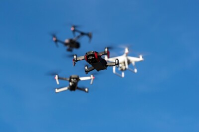
DJI introduced new tools to develop professional drone apps during the first DJI AirWorks conference. The major expansion of DJI’s software ecosystem allows developers to create drone apps which can be used in an enterprise setting and control drone operations in an especially notable way. It's a major step designed to bring aerial technology into a wide range of professional activities from the world’s leading maker of unmanned aerial vehicles.
The company announced the software advances on the first day of its inaugural DJI AirWorks conference which gathered a wide range of innovators in San Francisco for two days of discussions to showcase today’s enterprise drone uses and share their vision of how drone technology will shape the future. The event allows participants to learn how innovative companies have adopted drones for their businesses and meet insiders from different industries who are pushing drone solutions to new heights!
With drone solutions for multiple segments of the market, DJI takes another bold step with the software development kit upgrades to make professional drone use easier. By opening and simplifying the software that operates drones, DJI wants developers to build on each others’ accomplishments to develop custom solutions for their own businesses or broadly distribute solutions for entire industries.

Michael Perry
“Drones are transforming industries from construction to surveying to agriculture to public safety, and the innovations we’ve seen so far have just scratched the surface of how drones can help enterprises work faster, safer, more efficiently and at a lower cost,” said Michael Perry, DJI Director of Strategic Partnerships. “DJI wants to help developers implement great new drone functions, and we’re excited to expand their ability to build exciting new custom applications.”
DJI introduced new features and improvements to both its Mobile and Onboard Software Development Kit (SDK) offerings, which allow developers to build custom solutions for enterprise. New features range from user interface libraries to speed up mobile app development, to an onboard trajectory planning and control framework that lets developers execute complex missions. DJI also introduced Ground Station Pro, a new flight app designed for planning and creating 2D and 3D maps, which can be integrated into third-party apps and is open for a public beta.
“We’ve created a library of new software building blocks for our
Onboard SDK, allowing developers to quickly and easily generate precise trajectories, capture lidar data, align and export point clouds, and halt trajectory control if an unexpected obstacle is detected,” said Darren Liccardo, DJI Vice President of Engineering, Systems and Applications. “With Onboard SDK, developers can now build a solution that plans a complex smooth path, executes it while monitoring for possible conflicts, and processes raw lidar data to create a point cloud that can be imported directly into an industrial workflow.”
The addition of user interface libraries to the Mobile SDK will allow app developers to significantly reduce their development time. Common user interface elements will be provided that developers can reuse in their application either as is, or with their own customizations.
“We want developers to focus their energy on pioneering new applications, not on duplicating efforts by creating another user interface,” said Robert Schlub, DJI Vice President of Research and Development. “This is an opportunity for DJI to make the process more efficient for everyone, so developers can quickly prototype and deploy apps that integrate our platforms into their workflow.”

The
AirWorks conference, held December 1 and 2 in San Francisco, features presentations from global industry giants as well as data and service startups, showing how the enterprise drone industry is coming of age on four major tracks – industry/inspection, public safety, agriculture and mapping/surveying. It also spotlights the work of AutoModality, which in August won DJI’s $100,000 SDK Challenge by developing an autonomous flight solution allowing a drone to launch from and land on a moving vehicle for disaster relief.

 The AirWorks conference, held December 1 and 2 in San Francisco, features presentations from global industry giants as well as data and service startups, showing how the enterprise drone industry is coming of age on four major tracks – industry/inspection, public safety, agriculture and mapping/surveying. It also spotlights the work of AutoModality, which in August won DJI’s $100,000 SDK Challenge by developing an autonomous flight solution allowing a drone to launch from and land on a moving vehicle for disaster relief.


Comments