


Recently, DJI partnered with Delair to collaborate on enhanced and integrated solutions for visual data collection and analysis for businesses. As a result, DJI is improving its technology to better support the commercial industry, and Delair will sell DJI products through its sales channel, along with launching a relationship to build compatibility across platforms.
To provide professionals with complete Mapping & Surveying solutions, DJI is now expanding the capabilities of its product portfolio.
“The product improvements we are introducing at InterGeo are significant steps to solidifying DJI’s role as a provider of a next-generation geospatial data collection platform – an essential tool and an integral driver of growth for countless service providers and solution developers,” said Dr. Barbara Stelzner, Director, Marketing and Corporate Communication, DJI Europe.
For example, the new Matrice 210 RTK V2 + Zenmuse X7 solution is fully capable of
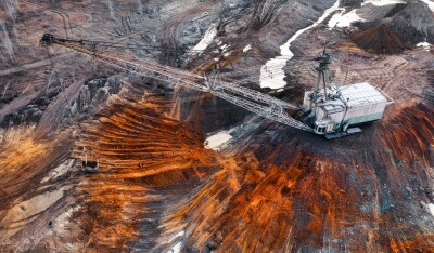
By partnering with Delair, DJI Systems will be compatible with the delair.ai Cloud platform, designed for various industries, including Mines & Aggregates, Construction, Agriculture & Forestry, and Power & Utilities. With the delair.ai platform, customers have access to a wide range of tools to help derive insights from drone data, including industry-specific analytics tools optimized for specific use cases. It allows users to create digital twins, field inventory calculations, vegetation encroachment, automatic defect detection, automatic stockpile detection
“Drones for enterprise are more than just hardware solutions: the real key is tapping into and leveraging the data these powerful machines can gather, “ said Benjamin Benharrosh, Co-founder and VP Sales at Delair. “DJI’s developer technologies and existing install base allow Delair to build an
To showcase these solutions, both companies were at the 2019 INTERGEO event in Stuttgart, Germany - Booth #C4.052 (DJI)and #A3.062 (Delair).


Comments