

Sponsored by ANELLO Photonics
Over the last quarter-century, perhaps no technology has fundamentally changed our lives more than GPS. While it has been around for significantly longer than that, the public-facing applications for the technology have been combined with the growth of the internet over a similar time period to quite literally change the way we live. From having constant access to directions to enabling precise pick-up and delivery, almost unimaginable convenience has been brought to our lives seemingly overnight with the advent of this technology.
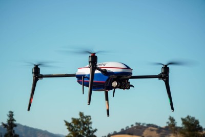
The effect GPS has had on the commercial drone industry has been substantial as well, as anyone who works in the field will know. In fact, at this point, the technology is likely so embedded within the field work that operators don’t think about it – that is, until it’s gone. That is the rub with this technology, and being too reliant on it. Having it as a basis for operations is great, but there needs to be a plan for what happens in GPS-denied environments, something that is important now but will only increase in importance as automation and BVLOS operations become more normalized. ANELLO Photonics has developed technology specifically to combat these issues.
How the Industry Got Here
To understand the problem, it helps to understand how we got here. Forty years ago, navigation required real skill. Operators used compasses, gyros, and dead reckoning — measuring speed, heading, and angle to estimate position over time. Then GPS arrived and, as Dr. Walter Stockwell, VP of Aerial Solutions at ANELLO, puts it, effectively erased all of that.
"GPS just made that so easy to know where you were pretty instantly and affordably," Stockwell said in a recent conversation with Commercial UAV News. "People realized, ‘Well, we can interpolate these GPS readings if we want to be even more accurate.’ And so they started using MEMS inertial systems, and you only had to interpolate for maybe 250 milliseconds or 100 milliseconds."
The MEMS-based inertial measurement units now found on virtually every commercial UAV were never designed to work independently. Instead, they were designed to bridge the gaps between GPS readings rather than to replace GPS entirely. This is a significant distinction. Remove the GPS signal, and those MEMS sensors lose not just a positioning reference but the calibration input they depend on to function accurately.
"A lot of drones won't even take off now," Stockwell said. "They just won't take off if you don't have GPS. You actually need the GPS to calibrate the MEMS. So you'll get potentially unstable flying where it can’t close the control loop, and the drone can become unstable."
The issue, in other words, is not simply that the aircraft doesn't know where it is. A skilled pilot could theoretically guide it manually in that scenario. The deeper problem is that the drone may not fly at all.
The Commercial Reality
GPS-denial sometimes gets discussed primarily as a defense concern in terms of jamming, spoofing, and adversarial interference. Those are real threats, as we are seeing in conflicts around the globe, but they represent only part of the problem space for commercial operators. Environmental GPS degradation is more common and less dramatic, which may be why it gets less attention.
"People started realizing there are a lot of interesting applications even on the commercial side where you're not necessarily being jammed, but you just have terrible GPS because you're going through orchards, you're going through tunnels, you're in a warehouse," Stockwell said.
Add to that list operations over water, over snow-covered terrain, in urban environments, or in any environment where a signal from nearby structures distorts positioning data, and the scope of the problem becomes clear. These are not rare, edge-case applications. These are routine operating environments for agricultural drones, infrastructure inspection platforms, and last-mile delivery systems.
When automation starts entering the picture, the issue only deepens. A single pilot managing a single drone can compensate for a lot. Once you start scaling that to ten drones operating with minimal human oversight – which is where the industry is hoping to head when BVLOS operations become more standard – and the tolerance for navigational uncertainty shrinks dramatically.
"If I really want to make money at it, I need to have 10 drones doing that, and ideally I don't have a pilot on each one," Stockwell said. "If I want to automate things, you have to start trusting that it's going where you want it to go."
Why Camera and Lidar Solutions Only Go So Far
The good news is that the industry has developed real workarounds. Camera-based navigation, lidar, terrain matching, and simultaneous localization and mapping (SLAM) approaches can all provide positional awareness in GPS-denied conditions.
There are still limitations for these methods, though. Camera systems, for example, degrade in low-visibility conditions that are common in real-world operations.
"It may be hard to use cameras because it's foggy or cloudy, or you're over water, or you're over snow, or you're in a tunnel that looks exactly the same from one foot to the next," Stockwell noted.
There is also a processing overhead cost that keeps these systems relatively expensive from a power budget standpoint. And there is a more fundamental issue that applies across all of them: Every one of these systems depends on an underlying IMU to know where its sensor is pointing. A camera-based navigation system is only as accurate as its knowledge of the camera's orientation. A lidar system has the same dependency. If the IMU has bias or drift, pointing error propagates through the entire system regardless of sensor quality.
"At the basis of all these other schemes, there's always an IMU of some sort," Stockwell said. "Is your accuracy limited by your pointing? Is it limited by some of these assumptions you're making about inertial measurements?"
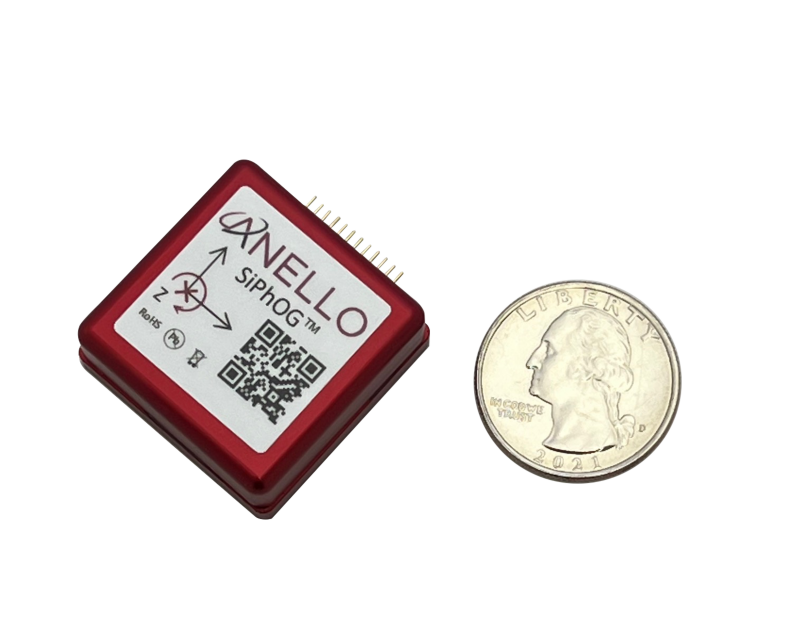
The SiPhOG: Optical Inertial Navigation on a Chip
This is the problem ANELLO Photonics has built its technology around. The company's core product is the SiPhOG — Silicon Photonics Optical Gyroscope — and the fundamental advantage it offers is straightforward: optical sensors are not affected by vibration in the way MEMS sensors are.
"MEMS technologies, especially gyros, are a vibrating plate, and you're detecting rotation by how that vibration moves as you rotate," Stockwell explained. "If you have any vibration in your system, that can potentially interfere with that sensor."
For drone applications, where vibration is a constant fact of life, this is a real liability. MEMS gyro manufacturers have traditionally addressed this with shock mounting, but even that solution introduces its own failure modes — if the isolation mount develops a resonance frequency, it can corrupt attitude measurements in ways that are difficult to predict or diagnose.
Fiber optic gyroscopes (FOGs) have long offered a solution to this problem. Optical sensors measure rotation using the Sagnac effect — light traveling in opposite directions around a loop, with the phase shift between them indicating rotation rate — and are inherently immune to mechanical vibration. The catch has always been cost and size. Traditional FOGs are assembled by hand from discrete fiber optic components: splitters, polarizers, combiners, modulators, each connected by spliced fiber. It is a labor-intensive process that makes them expensive and difficult to scale.
ANELLO's breakthrough was integrating those components onto a single silicon photonics chip, a manufacturing approach pioneered in data center optical interconnects. The company's founder, Dr. Mario Paniccia, led silicon photonics development at Intel before founding ANELLO, and brought both the technical knowledge and the manufacturing relationships to make it viable for a small company.
"All those discrete components are like electronics 40 years ago, where you had a resistor with two leads coming off that you soldered in," Stockwell said. "Each one of those things is a manual process and also very prone to failure. [Dr. Paniccia] knew how to take all those discrete components and put them onto one chip — that makes it much more rugged, much smaller, and much easier to produce."
The result is a product that offers FOG-grade performance at a form factor and price point that is actually accessible to commercial integrators.
"We are the same performance as the optical gyros, but lower power, lower size, lower cost," Stockwell said.
A Layer in the Stack
Stockwell is clear that ANELLO is not positioning the SiPhOG as a GPS replacement. The goal, rather, is to create a navigation layer that keeps the aircraft stable and on course when GPS degrades or disappears, while also improving the accuracy of every other system in the stack.
"GPS is such a powerful, easy technology that gives you such great information when it works," Stockwell said. "When it's not working well or not working at all, I think you benefit from thinking about it in different layers."
On the commercial side, the current target applications cluster around larger platforms where the form factor of the SiPhOG is less of a constraint: heavy-lift drones, agricultural systems, and precision payload platforms where pointing accuracy has a direct effect on data quality.
"The kinds of commercial applications we're going for are more the bigger heavy-lift things, or agricultural things, or bigger cameras, where people would be interested in better pointing, and where people are interested in resilience," Stockwell said.
The regulatory trajectory reinforces that direction. As BVLOS operations expand under frameworks like the anticipated final Part 108 rule in the U.S., and as the category of approved aircraft grows to include heavier platforms, redundant and resilient navigation will likely move from a competitive differentiator to a compliance requirement.
"There are going to be requirements for redundant systems and resilient navigation," Stockwell said. "[Part 108] is going to allow things that are thousands of pounds. In those situations, there will be a lot more calls for something like us."
The commercial drone industry has spent years building operational capability on a GPS foundation that it cannot fully control at all times. Environmental degradation, signal multipath, and the demands of scaled autonomous operations all point to the same gap. ANELLO's silicon photonics approach addresses that gap directly, bringing optical gyroscope accuracy to a chip-scale form factor that is accessible to commercial integrators for the first time. For operators and system designers who are serious about navigational resilience, whether they are flying heavy-lift platforms today or preparing for the BVLOS landscape ahead, the SiPhOG represents a meaningful step toward a navigation stack that can perform when GPS cannot.
To learn more about the ANELLO SiPhOG go to https://www.anellophotonics.com/


Comments