

A Swiss-Austrian consortium will test large-area laser scanning applications in the Swiss Alps, using innovative drones.  The partners are Dufour Aerospace, RIEGL, BSF Swissphoto and the SLF, who will collaborate for a series of test flights over several months.
There is growing interest among various private and public stakeholders in high-resolution, up-to-date and cost-effective data, particularly in the area of alpine environmental hazards or energy production. Today, aeroplanes and helicopters are used for large-scale, high-resolution laser scanning. This test series will demonstrate the efficiency of drone application with a view to a lower environmental impact and significant cost reductions.
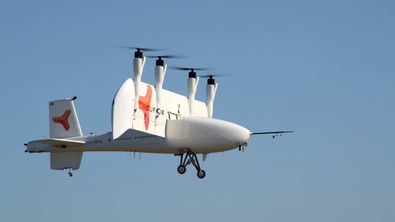
Dufour Aerospace will support the project with its 3-metre-wingspan AeroMini and 6-metre-wingspan Aero2 UAS platforms. RIEGL will provide the laser scanners and help with the integration. BSF Swissphoto will contribute to data validation and assess the commercial relevance of the technology and the processes. The WSL-Institute for Snow and Avalanche Research SLF will ensure that the data quality meets quality requirements, and serves applied science use cases and supports the field test with experienced personnel.
Dufour Aerospace Co-founder and CEO Thomas Pfammatter said: “This is a fantastic opportunity to demonstrate the capabilities of our AeroMini and Aero2 vertical take-off-and-landing uncrewed aerial systems in relevant applications. We’ll have a shared, clear aim of increasing efficiency in data generation medium and long-term, supported by renowned, experienced partners. We can't wait to start.”
RiCOPTER UAV GmbH (a RIEGL company) Managing Director Michael Mayer said: “While we already have a lot of experience with using our high-end sensors with UAS, this is nowadays mostly limited to smaller areas using multicopter types, single-rotor drones or VTOLs of smaller scale. This project will help us to understand the potential of drones in larger scale, covering large application areas in order to exploit the performance of our high-end devices even more. As a quality-conscious high-end producer of laser scanners, we are predestined to contribute our expertise.”
BSF Swissphoto CEO Jörg Wertli said: “For some time, drones have been around for aerial geo data acquisition, but only usable for small areas. Dufour Aerospace develops a platform suitable for projects that can only be realised with crewed planes today. The planned test series lays the basis for autonomous, large area aerial geo data acquisition. We are excited to be part of it.”
WSL-Institute for Snow and Avalanche Research SLF, Dr. Yves Bühler said: “As a leading national research institute, we rely on up-to-date, cost-effective and high-quality data for our own analyses as well as for services. We are pleased to represent the applied science side of this test setup and to contribute our experience in high alpine terrain. We are convinced that much progress is still possible, especially in the field of snow- and mountain hazard research.“
The test series is expected to begin this spring in Dübendorf, Switzerland, with basic functional tests and will then be extended to the Alpine region in the course of 2024 and 2025, depending on the results from each individual test series. This project is also supported by the Fondation The Ark and armasuisse.
Source: Dufour Aerospace

.jpg.small.400x400.jpg)


Comments