

Germany, Munich, March 21st, 2023 – Quantum-Systems GmbH, an aerial intelligence company that provides multi-sensor data collection drones to government agencies and commercial customers, today announced the joint launch of a project on the early detection of forest fires using artificial intelligence, data, drones and decision support systems, in cooperation with The [ui!] Urban Mobility Innovations, the Technical University of Deggendorf, the University of Bayreuth as well as the State Fire Brigade School Würzburg.
Founded in 2015, Quantum-Systems is at the forefront of UAS development. Its electric vertical take-off and landing (eVTOL) systems boast industry-leading flight endurance, ease of operation, and reliability. The 2-in-1 vertical take-off reconnaissance UAS, VECTOR™ provides long-endurance, versatility, and flexibility, exceeding the performance of conventional UAS platforms.
About KIWA
Funded by the German Federal Ministry for the Environment, Nature Conservation, Nuclear Safety and Consumer Protection (BMUV) with a volume of approximately 1.8 million euros, the project aims to set new milestones in forest fire fighting with AI support. The project "AI-based Forest Monitoring - Artificial Intelligence for Early Detection of Forest Fire Events" (KIWA) will use advanced technologies to identify and predict potential forest fire risks to enable early prevention and intervention measures.
AI-based Forest Monitoring Solutions
Imagery data and analytics will be used to detect and monitor areas at risk for wildfires. Quantum-Systems’ Unmanned Aerial Systems (UAS, colloquially known as "drones") are used to collect remote sensing data and assist with mapping. Via an Open Urban Data Platform, data will be evaluated in real time and transmitted to a specialized application for use by institutions such as fire departments and disaster management teams. This is done to localize forest fires as precisely as possible at an early stage and to make them effectively controllable with appropriate measures.
Artificial intelligence will play an important role in this project, namely by analyzing large amounts of data collected from satellites and drones, among others, to identify patterns and trends that indicate a fire risk and or possible fire event. This will enable agencies to better target resources and take timely action to best prevent a wildland fire outbreak or control the fire. Here, a range of data sources, such as current weather data, climate data, and imagery data, are integrated to assess a situation and provide the appropriate basis for action. Decision support systems such as dashboards provide real-time updates and the ability to alert stakeholders, including fire departments and local authorities, thus enabling a rapid and efficient response to potential fire threats.
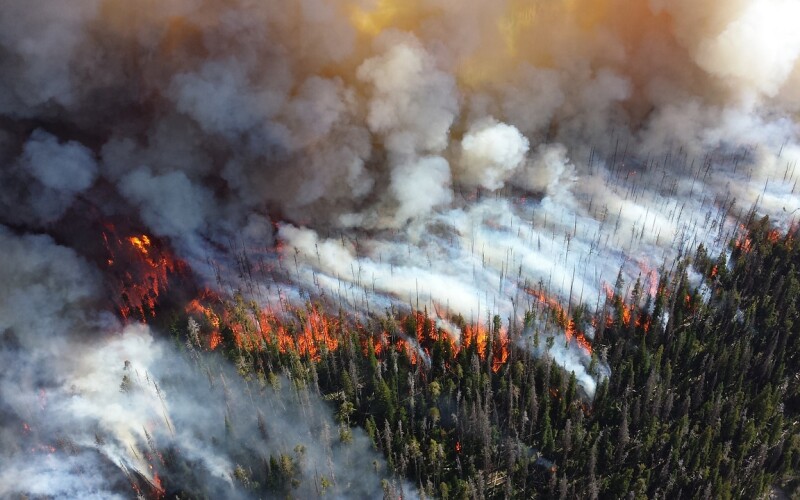
Forest Fires Associated Risks
Forest fires contribute a significant amount of CO2 emissions each year that contribute to climate change. Studies estimate that forest fires are responsible for about 5-10% of global CO2 emissions and accelerate climate change. As reported at the World Meteorological Organization's Davos 2023 conference, the average annual global cost of forest fires is more than $50 billion, which has increased sharply in recent years. It was also noted that global wildfires released more than 6,400 megatons of CO2 into the atmosphere in 2021 alone, and that a huge increase in extreme fires worldwide is expected by 2050. In addition, fire patterns are significantly impacted by changing weather patterns due to climate change, making traditional methods of detection and notification less effective.
The project will not only support the basic research needed for this but is already envisioning appropriate business models. The solution developed by the KIWA project will enable institutions such as fire departments, disaster management teams, counties or cities to be more resilient in the face of increasing forest fire risks due to the climatic changes of our time. All interested parties are invited to participate as an associated partner in field trials of the developed solutions or to participate in their development.
Project Partners
The consortium consists of four active project partners: [ui!] Urban Mobility Innovations (B2M Software GmbH) as consortium leader is an expert in data analytics, artificial intelligence and open urban data platforms while focusing on innovative, data-driven solutions for municipalities.
Quantum-Systems GmbH is an aerial intelligence company that provides multi-sensor data collection drones to government agencies and commercial customers, to transform decision-making processes.
In addition, the Institute for Applied Computer Science (IAI) - Deggendorf Institute of Technology and the University of Bayreuth with the Professorship of Biogeography and the Professorship of Disturbance Ecology scientifically accompany the project in its implementation and provide the necessary knowledge from basic ecological research. We are also pleased to welcome the Staatliche Feuerwehrschule Würzburg as an associated partner in our project - who will help us with their broad expertise on the status quo of forest fire monitoring.


Comments