

The most dramatic example of an economic miracle in Latin America is Chile. With a population of 20M people, Chile is currently the biggest producer of copper in the world and one of the largest exporters of wine and agricultural products in the region. In order to feed the growing demand for pulp and wood products worldwide, another area in which Chile is investing heavily is forestry. With the growth of an industry besieged by risks given the sheer size of plantations and the nature of the trees involved, inventory and constant monitoring is a must.
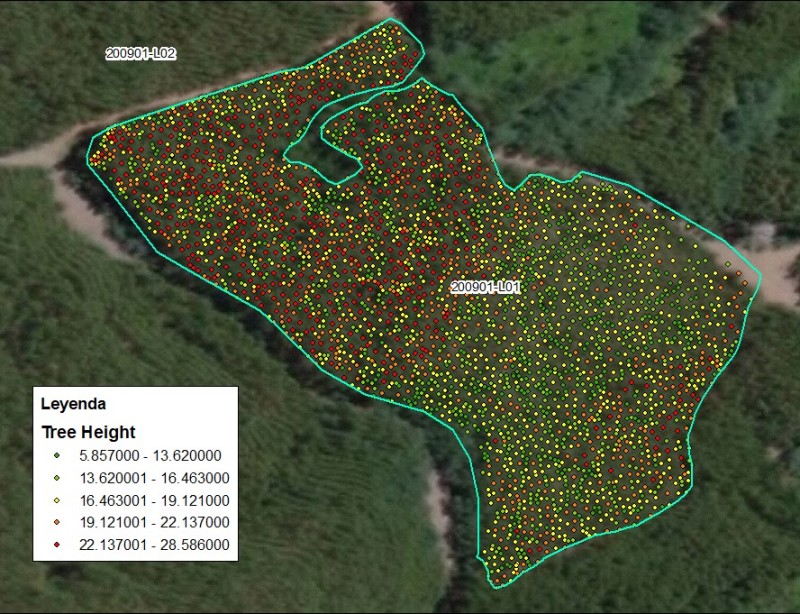
Forest inventory is the systematic collection of data and forest information for assessment, analysis, and harvest planning. The inventory determines the precise location of timber, quantifying volume by species, product potential, size, and quality among other characteristics. An estimate of the product value is of great importance to forestry companies or government entities in charge of forest management.
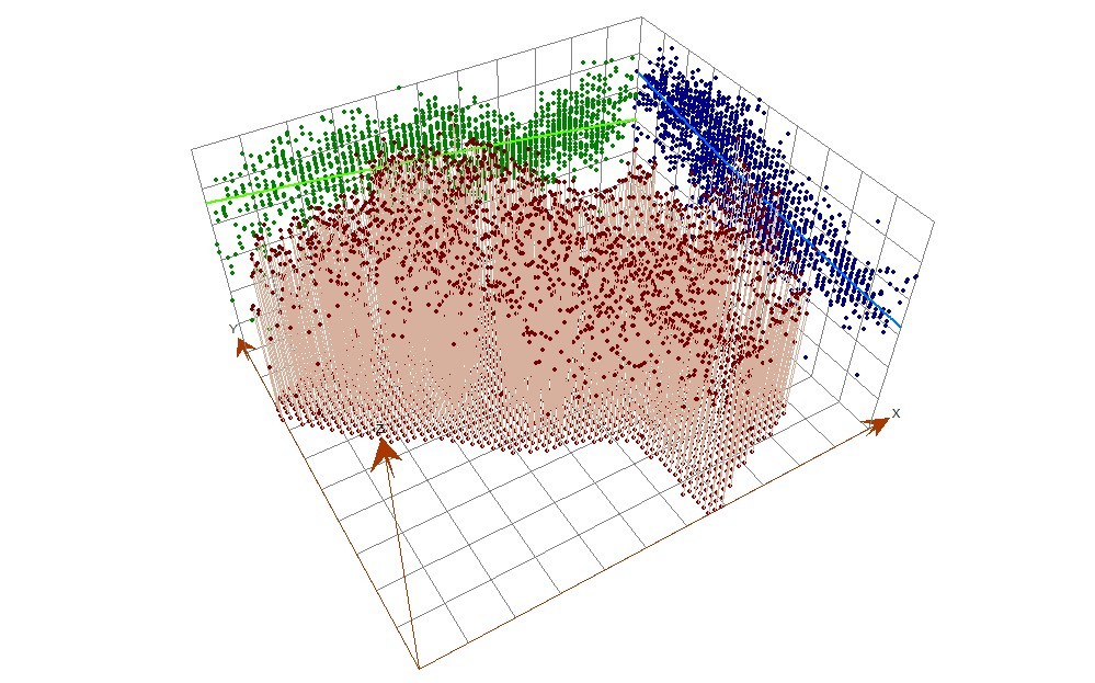
Unmanned Aerial Vehicles (UAV's) are relatively new platforms that have been increasingly used for forestry applications. The advancements in technology render great benefits and the added value of flexibility, low cost, reliability, autonomy, and capabilities for the timely provision of high precision, high density and high-resolution data. High density LiDAR data acquired using UAV’s, known as Unmanned Laser Scanning (ULS), offers new opportunities for forest inventory.
Unmanned Scanning (ULS) and Terrestrial Laser Scanning (TLS) are projected as the two most efficient capture technologies for forest inventory and is considered better than Airborne Laser Scanning (ALS) because of the level of density and data precision. Commonly with ALS, users can obtain point clouds with 4 to 20 points per square meter, while with ULS or TLS users can obtain between 200 and 3,000 points per square meter.
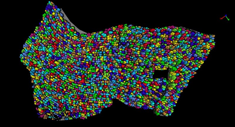
For more than two years, engineers from LiDAR Latinoamerica (LL)—a specialized company from Chile—have conducted research and development field surveys using LiDAR in more than fifty sites in Costa Rica, Peru and Chile, gathering data to learn how to detect and measure forest mass and individual trees attributes. These included areas from natural forests, but also from industrial plantations, Eucalyptus Globulus and Pinus Radiata.
Commercial UAV News had the opportunity to talk with Alejandro Chumaceiro, founder and CEO of LiDAR Latinoamerica, for a more detailed explanation of their technology and plans.
“LL´s approach to using ULS has created an end-to-end workflow that includes capture, process, analysis and distribution of meaningful information derived from the LiDAR data,” said Alejandro. “We aim to offer organizations across the forestry industry vital and timely data points for their engineers to understand the current state of the plantation, including estimation of tree height, tree XY location, dbh (diameter at breast height), crown diameter, crown area, crown volume, stand volume, biomass, and carbon stocks.”
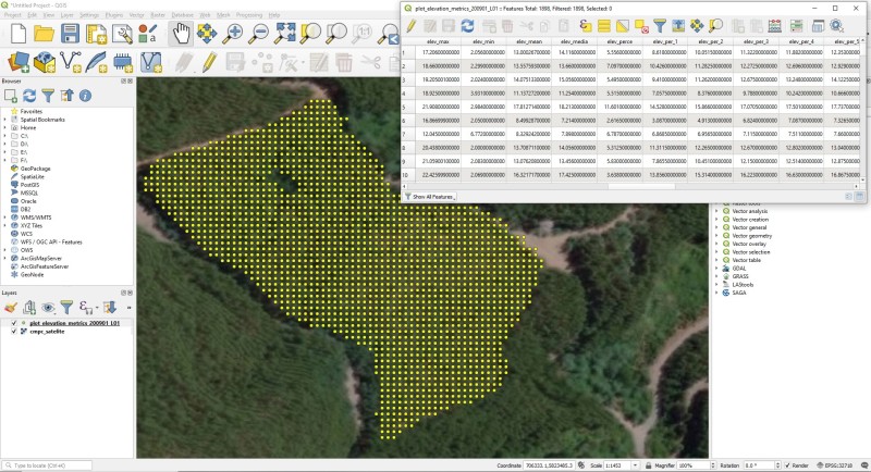
The resulting product is a set of georeferenced shapefile files (.SHP) and/or a geospatial database that can be used for geostatistical analysis, like planning operations and estimating harvest.
“One of the main challenges we face is to create more efficient and scalable processing methods to be able to exploit the continuous advancements of ULS technology, which produces very large point clouds due to greater resolutions and densities,” explained Alejandro. “Covering an entire forest with LiDAR requires data intensive processing power, which can overwhelm the available RAM memory, CPU/GPU processor and storage capabilities of a typical workstation. It can take an unacceptably long time to sequentially process it all. We decided to use high-performance computing to solve the problem, by making cloud computing web services with LiDAR data available and accessible for everyone. The wealth of information LL can provide is unprecedented. For field crews, for example, they can identify wood stacked on the roads, quantify the number of trees on the stand, estimate its volume and its precise GPS location to support the logistics needed for its extraction.”
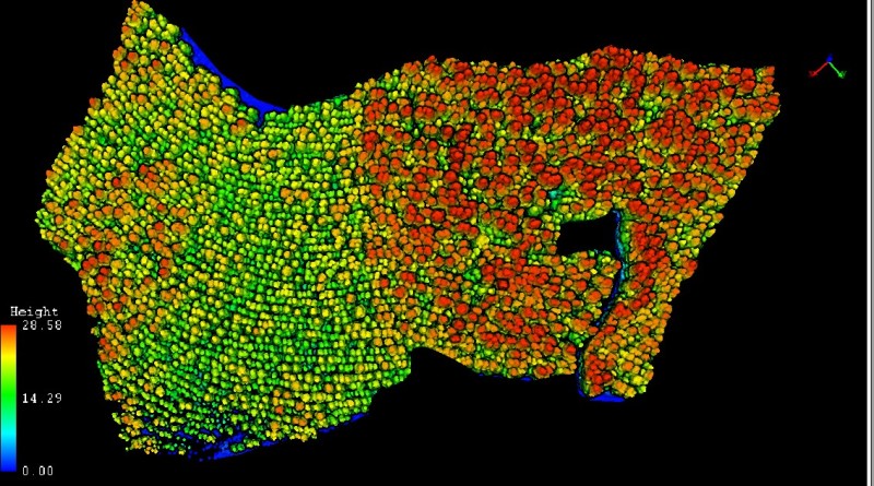
In addition, LL can reconstruct the current state of forest stands, producing a 3D Digital Forest Model (DFM) and extract key information to control the right execution of harvest works. Typically, forestry professionals spend a lot of time in the field and need information to plan operations and decision making, with this technology, it is possible to get the inventory faster, minimizing field data acquisitions by hand.
Lastly, LiDAR technology facilitates forestry companies’ planning, giving engineering personnel the necessary information to reduce costs associated with road building and cable logging. This makes foresters and engineers more productive both in the field and in the office, which in turn helps forest operators increase harvest efficiency.
By adapting existing technologies to local needs, LiDAR Latinoamerica has managed to create a unique set of skills and workflows that are easily adaptable to requirements of other industries.

.jpg.small.400x400.jpg)


Comments