

There has been a lot of talk about how easy it is to utilize a drone on the farm, but there’s also been hesitation on the part of growers to really explore what this technology can do on a practical level because of regulatory issues. With Part 107 soon to go into effect, one of the biggest challenges that many farmers have identified will soon be eliminated, which will free farmers across the country to explore how drones can impact their approach. Part 107 will require UAV operators to pass an initial aeronautical knowledge test at an FAA-approved testing center. Upon completion of the aeronautical test the UAV operator will be able to operate commercially in the United States.
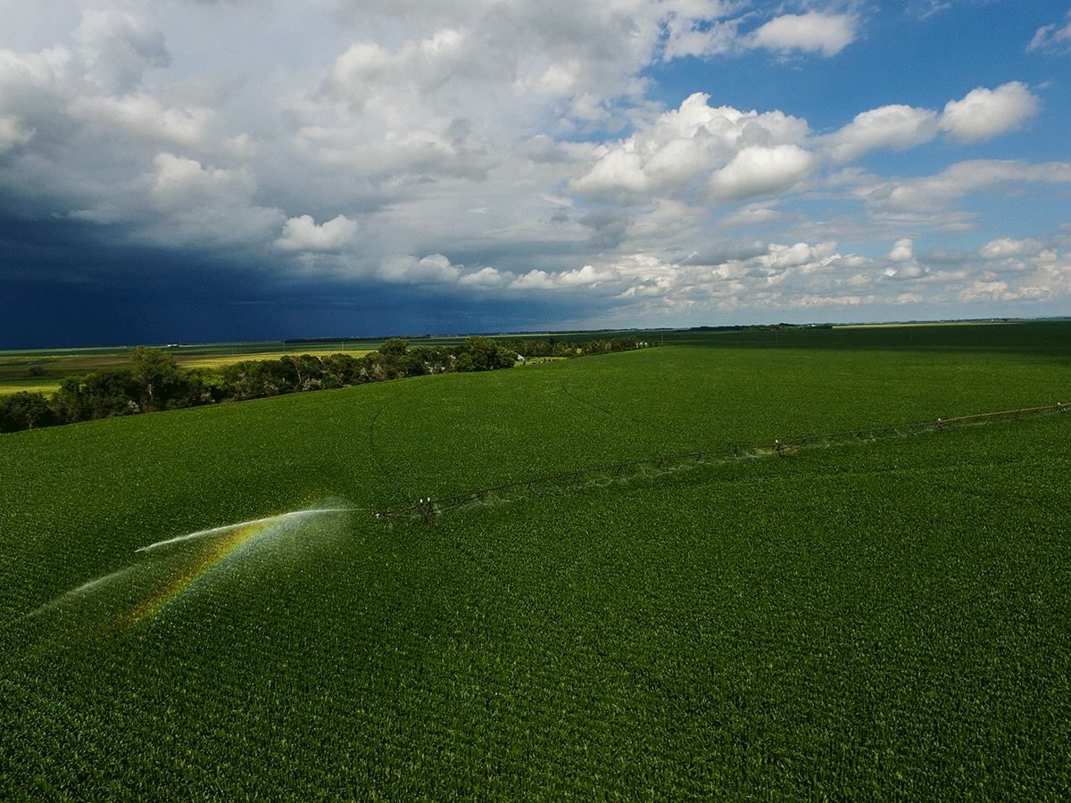
Much as I’d like to be able to make a recommendation around an approach which is going to be applicable to the ag industry as a whole, that simply isn’t possible. A one-size-fits-all approach around the implementation of drone technology simply doesn’t work on the farm. Drones on the FarmIt’s really important to know what you want to do with a UAV on the farm, and that’s probably one of the biggest gaps right now for farmers. Simply put, most of them just don’t know what the drones can actually do. A lot of growers are just getting interested in learning about the possibilities and potential. At that point it’s going to be about connecting with trusted advisors and figuring out what’s going to work on their specific operation.Scale is huge factor for this issue. A lot of similarly sized farmers who are smaller and just getting into this technology will use one type of drone, and then the higher commercialized bigger acre farmers are going to use a different type of drone. Maybe they’re growing a similar crop, but the tools and process each of those operations use could be totally different, even though they might be looking to gather the exact same information.A couple years ago, when we were just getting into using this technology, we bought into a type of drone service that was saying they could capture just about anything we wanted and provide us with pictures and information that would really be able to make a difference. They ended up not being able to deliver, but things have come a really long way since then. Growers should have the ability to see for themselves if something works before they buy into it. We’re at a point where we can assess how and if UAVs will be a fit in a specific environment before making a huge investment. Making a DifferenceMost of my research is in the Midwest with corn and soybeans, and there’s a huge amount of research going into these crops because they’re the largest acres in this area. Many of the things we’ve been wanting to do and try with UAVs were being limited by regulation, but with Part 107 taking effect in August, it’s going to open up all kinds of possibilities.Those possibilities will mean something different to different types of growers. High value crops – grapes, almonds, etc. - will find a lot of use with drones because they’re smaller operations but you have more dollar per acre. That’s where the specificity of drones, in knowing where each crop is and being able to see and analyze it, is really valuable.That value will be seen in terms of how the drones are being utilized specifically. Most people out in the Midwest are just using UAVs for scouting pictures. There are very few people doing any actual mapping for service. We’re doing some mapping, but it’s just internal research on our own farm, and we give that info to our growers to show them what the technology can do and how they can use it if they wanted to themselves.The sensors are getting better every year so that we may soon be able to identify specific weeds just based off their reflection. Together the UAVs and sensors can work together to create very accurate topographical maps which can be used to determine water movement and availability to plants within a field. If you’re mapping fields, you can actually utilize those maps to do prescription variable rates, side dress applications or making zones for the next year. That’s definitely going to impact the return on investment of the next season. What info is being gathered via a drone?The biggest question farmers can and should be asking when it comes to utilizing a drone revolves around what they’re going to do with the info the UAV captures. You have to remember that drones are just another tool. Right now they can help you make more informed decisions and give you more data, but the way that info can and will influence those decisions is a key consideration.Do you just want to fly up and take some scouting pictures and visually see your farm from that elevated position? Or do you want to actually map the field, where you go out and fly a mission to map all those pictures and then get them stitched together in an orthomosaic? Right now there’s a pretty big gap between the people who would do something like that versus people just taking pictures for scouting purposes.If you can or want to use a drone for mapping, you have to have the equipment to be able to do variable rate alongside with that data. If you don’t have that equipment the data you capture can easily get lost, and you’ll likely have more info than you’ll be able to use or even sort through.To take this a step further, when scouting, a farmer is typically just using an RGB camera, and then once they get to mapping they can still use that RGB camera. Regular RGB cameras can be modified to allow the infrared spectrum to be captured, which can be used to create an NDVI map. These modified cameras work to show variations in a field but do gather a lot of extra noise and cannot be repeated because they are generally not calibrated. Another step forward would be a multi-spectral camera which is even more bands of data and is also usually tied together with a light balancer which allows images to be repeated and compared over time. That’ll take someone with an even greater understanding of what to do with this data, because then you need to know what you can and should do with these bands of light.Going from scouting to mapping to gathering multi-spectral images represents a progression that might not be suitable or wise for many growers, but all of that depends on how they can or want to be able to utilize the data gathered from a drone. Decisions about how this info can and will be used need to be made before it’s captured. Where do farmers begin?Everyone can get involved with scouting right away because it isn’t expensive. The DJI phantoms are super cheap right now, and they work great. You can do a little bit of mapping with them, even though they’re a bit limited on battery power.Everyone could benefit from getting one of those just to get a sense of what you can do with quad copters and scouting. Then you can try some mapping and see if that’s for you and even take the next step to multi-spectral. Of course, whether or not that’s going to be the best fit is something you can and should consider before making an investment of time and/or money.A drone isn’t going to solve all of the problems a grower might be having, and in many cases they won’t even give them information that couldn’t be gotten via satellite or a manned aircraft. However, UAVs have the potential to ease or eliminate certain tasks and issues that farmers might be struggling with as well as capturing info in a cheaper or more efficient way. With Part 107 substantially lowering the barrier to entry, there’s no better time find out how they might be a fit for you.


Comments