
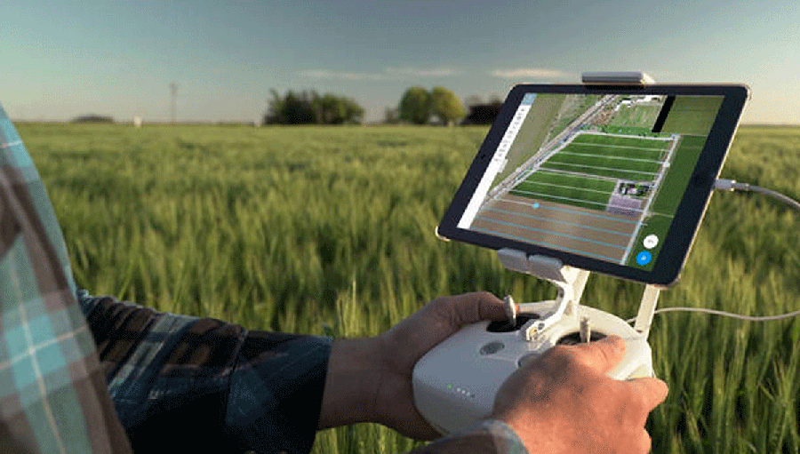
If you own an iOS device and a DJI drone, real-time mapping is now available. DroneDeploy has launched the Fieldscanner beta project, which is an experimental new tool designed to create a map as your drone flies so you can take action before it lands.
DroneDeploy already offers a cloud software platform that allows for flight planning, data processing to create maps and 3D models, and information analysis at any time. It also features an App Market, which we’ve written about in the past, that connects other applications directly with DroneDeploy. To extend the software’s functionalities, and to provide users with what they have been asking for, DroneDeploy developed Fieldscanner.Instead of wasting hours uploading and processing drone data to a computer, Fieldscanner can capture a field map in minutes. This new farmer-targeted application allows drone users to create maps in real-time and analyze them on the spot through a mobile device. No Wi-Fi or cellular network is required. Therefore, you can take it anywhere with you, deploy your drone and you’re set.Fieldscanner creates a low-resolution map, which is viewable on a mobile device. When the drone lands, Fieldscanner informs crop scouting and helps growers take notes in the field. If you have a network connection, you can pin notes and photos of findings directly to the map."Time is in short supply on the farm, so when considering a new tool, the faster and easier, the better," said Jim Love, Light Robotics Manager at Beck's Hybrids. "With the ability to capture data in minutes, offline, with just a drone and a phone, Fieldscanner represents the missing link that will transform drones from useful tool, to a must-have for weekly crop scouting."Fieldscanner can help farmers with different tasks, such as spotting weeds and pests; detecting plant stress to inform nutrient application and monitor results; evaluating crop damage from weather events; and monitoring dry-down and decide when to harvest to maximize yields."This is just the beginning," said Jono Millin, co-founder and Chief Product Officer at DroneDeploy. "We already have exciting new improvements in the works to further unlock the potential of real-time mapping."It’s important to see solutions like the Fieldscanner being developed, as they help define how users in industries like agriculture can use these tools to create efficiencies and opportunities. Other solutions provide similar abilities, but Fieldscanner's option to create maps and 3D models is unique.Fieldscanner is in beta and available for all DroneDeploy users who own an iOS device and a DJI drone.Subscribe
The information you submit will be stored and used to communicate with you about your interest in Commercial UAV News. To understand more about how we use and store information, please refer to our privacy policy.
April 25, 2017
DroneDeploy’s Fieldscanner Set to Enable Real-Time Mapping with a Drone

Want more stories like this? Subscribe today!


Technology in general makes João Antunes tick, but the specific ways it has created and changed the landscape in IT, gaming and computers ignited curiosity that’s turned into a passion for him. As the son of a journalist writing about how these industries have emerged and evolved, he has an incredible perspective when it comes to understanding the kind of disruption new technologies can create in a given space. He’s committed to showcasing what that disruption will mean for professionals as they work to utilize brand new pieces of hardware, software, systems and processes.
Featured Report
Featured Authors More Authors ›

Featured Authors


Newsletter Signup
Our Events


Our Events
September 1-3, 2026 • Las Vegas
February 23-25, 2027 • Salt Lake City
Comments