

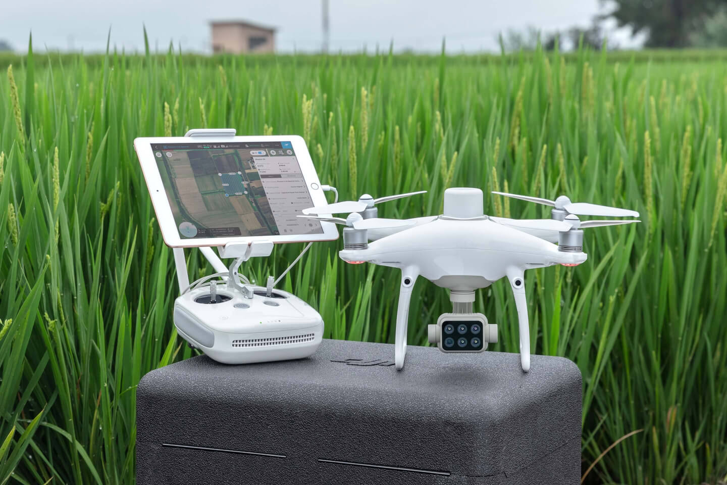
At AirWorks 2019 DJI announced its release of the P4 Multispectral drone that has been specifically designed to be utilized in agriculture and for land management. Until now, multispectral hardware for drones has only been available as add-ons, which has always required some degree of engineering to set up. This set up time has been cumbersome for the agriculture industry. By integrating multispectral cameras into its drone platform, DJI is offering farmers with the first fully integrated, plug-and-play option.
The P4 multispectral drone comes with a six-band camera covering RGB, blue, green, red edge, and near-infrared bands, which is the industry standard for multispectral imagining. Each color in the spectrum allows farmers to see unique information about the health of their crops that they would not be able to see with the naked eye.
Instead of having to use targets to calibrate ambient lighting conditions, the P4 has an integrated spectral sunlight sensor that captures ambient lighting conditions while it is in flight. This feature ensures that data is accurate and consistent even when captured at different times of the day. According to Jan Gasparic, DJI’s Director of Strategic Partnerships, this allows users to switch between a preliminary Normalized Difference Vegetation Index (NDVI) analysis and the live RGB feed to immediately visualize where attention is needed, so targeted treatment decisions can be made quickly.
When paired with real-time mapping data from LiveMap through DroneDeploy, farmers no longer have to wait for their data to be uploaded onto their systems when back at the farm. Mike Winn, CEO of DroneDeploy, mentioned that the P4 allows the farmer to walk over to examine trouble spots while the drones are still in the air.
When compared to traditional inspection methods, there are real benefits to utilizing drones for field inspections. A drone can cover larger swaths of land in a shorter amount of time, reducing the time it takes to inspect a field from months to just a few days or weeks. This not only allows an operator to check their crops more frequently, but it also provides them with better, more-accurate data. When talking about a $132.8 billion industry in the United States alone, this can mean real cost savings for farmers. According to Gasparic, “Multispectral has the promise to transform the agriculture and land management industries by collecting precise plant-level data without having to send personnel into the field for manual surveys.”
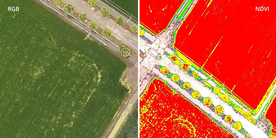
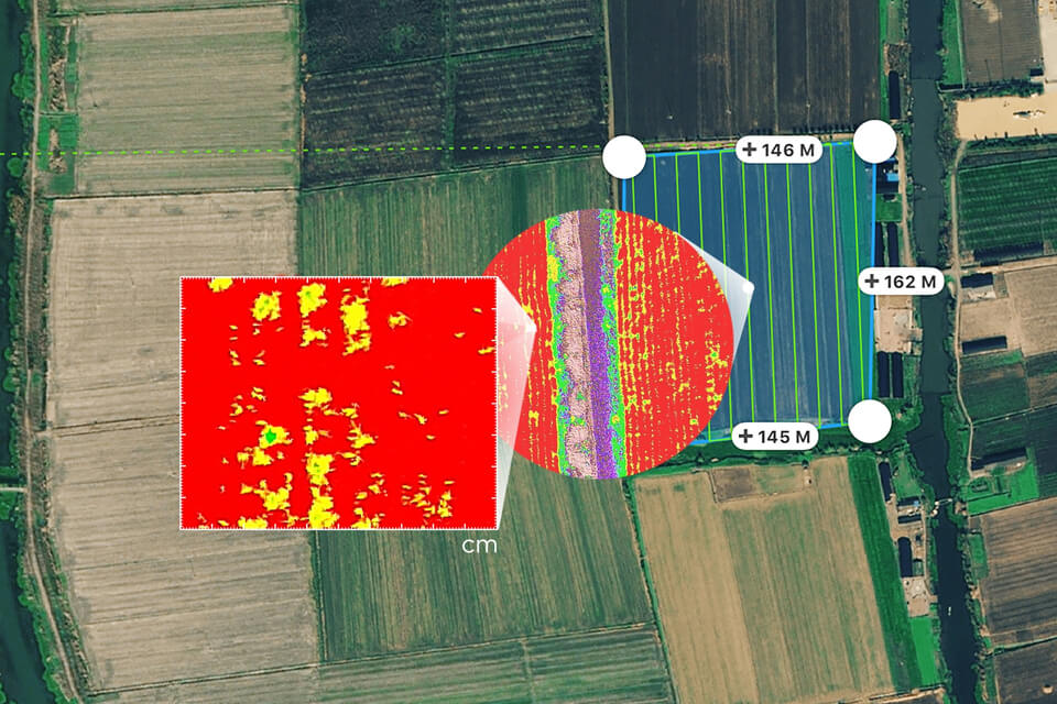
The P4 Multispectral drone is set to further enable benefits in this sector that are already being realized in a major way. Bowles Farming recently saw tangible results for their bottom line when deploying drones to determine which part of their 12,000 acre cotton field needed to be re-sprayed with defoliant (a chemical that dries the plant so that it is easier for the cotton picker to pick out the cotton fibers) before harvesting. In order to accomplish this, Justin Metz, a Technology Integration Specialist at Bowles Farming Co., used DroneDeploy’s Visible Atmospherically Resistant Index (VARI) to get a read on plant health by measuring how much green each plant was reflecting. He was then able to create a variable rate map from the data showing him the areas that he needed to re-spray with defoliant. When each spray costs somewhere between $11 to $15 per acre, being able to identify—up to the centimeter—which plants needed to be re-sprayed meant huge savings for his business; he was not only able to save money by only targeting the plants that needed defoliant, but he was also able to get the maximum yield from his crop by knowing exactly when his cotton plants were ready for harvest.
Examples like this are evidence that multispectral drone technology is allowing farmers and growers to make better-informed, targeted decisions about their crops. DJI’s P4 Multispectral drone is set to enhance these benefits in a tangible way and allow them to take these benefits to the next level.

.jpg.small.400x400.jpg)


Comments