


The morning after fire has destroyed most of your vineyard, you realize that you must decide whether or not to replant. Your UAV with multispectral imager was optimized to detect water stress using specific wavelength bands, but now the plants are gone and you wonder about the quality of the soil, now strewn with combustion products. Several camera vendors have already contacted you, including some who sell hyperspectral imagers. Hyperspectral… it has a nice techno ring to it, but how would you know if it meets your imaging needs?
You manage a large oil refinery where thermal cameras mounted on UAVs have successfully detected tank corrosion and leak locations. You want to go one step further by identifying specific contaminants in the refinery offgas. You think you may need a spectrally-selective technique, but several options present themselves including filtering the camera’s broadband output and using a Lidar sensor. What information do you need in order to communicate well with a camera vendor or solution provider?Your neighbors report seeing people at the edges of your large ranch during nighttime hours, but they seldom stay in one place and can be seen moving near the trees. While you can’t legally operate your UAV with thermal imager at night, is there any value to mapping your area during the daytime?These scenarios illustrate that as the UAV market continues to expand, the variety of imaging solutions to any problem may seem overwhelming to data end users and enterprise decision makers. The following paragraphs discuss basic concepts that can help decision makers become more intelligent consumers.Lidar (Light Detection and Ranging) can be used to create a number of data products, including digital elevation models, topographic maps, and canopy height profiles. It can also be used to detect gas constituents, including pollutants from smokestacks. In operation, the laser source at a specific wavelength directs pulsed energy toward the target and receives a reflected signal back. Because the pulse initiates imaging, Lidar is referred to as an active sensing techniqueThe majority of imagers that fly aboard UAVs are passive sensors that do not send out a pulse. Instead, they make use of a target’s material properties, particularly its reflectance or emittance. Reflectance-based imaging dominates in the visible spectrum and the near infrared (NIR), with the source of radiation usually being the sun. Emittance dominates in the thermal infrared, so two adjacent objects having the same temperature but very different emittances can show up with enough contrast to be differentiated when a thermal infrared camera is used to image them. While this type of camera is often used to image people against a background at night, a human can show up in daylight imaging against a colder background (such as snow.)The figure below illustrates the electromagnetic spectrum, including those regions where we see the majority of UAVs operating. The visible wavelength region is the portion of the electromagnetic spectrum over which the human eye is sensitive, and extends from about 0.38 micrometers to 0.76 micrometers. A micrometer, often referred to as a micron, is 1 one-millionth of a meter. Given that a meter is a bit longer than 3 yards, a micron is a very small unit of measure.Color is a property of human vision and it is common to see RGB cameras in UAV applications. Color-specific filters providing red, green, and blue are designed into the system, and further processing allows the full color spectrum to be rendered in the output image. When filters are not part of the camera, a grey-scale image is produced. Applications for visible imagers span the UAV solution space, from construction management to infrastructure inspection to aerial real estate photography.The near-infrared is a small portion of the spectrum just outside the visible, extending to about 1.4 micrometers or further, depending upon the imager’s detector. This small spectral region has been very valuable since the earliest days of the NASA Landsat satellites to assess plant health, and it is used in precision agriculture today. NIR cameras employ a false color system to produce images in which healthy vegetation appears red, while less healthy vegetation typically appears grey. This information is valuable to the farmer or vintner, as plant stress information shows up in the NIR before it may be seen with the naked eye. As in the visible region, the dominant physical process in the NIR is reflectance.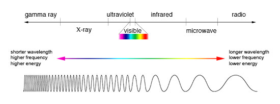
Credit: NASA’s Imagine the Universe


Comments