

After 18 months since the release of its desktop-based solution, Twinsity launched TWINSPECT, a cloud-based platform, to "unleash the power of drone inspection data" and make structural inspections safer, easier, and more cost-effective.
Nowadays, the lifecycle of infrastructure, industrial sites, and buildings is usually connected to a Digital Twin – a digital 3D copy of the project at hand. Not only can Digital Twins provide easy and remote access to an always up-to-date state of a project, but they can also help avoid significant financial and security challenges through early damage detection and prevention, which is a time-consuming, high-risk, and prone to error task in real-life.
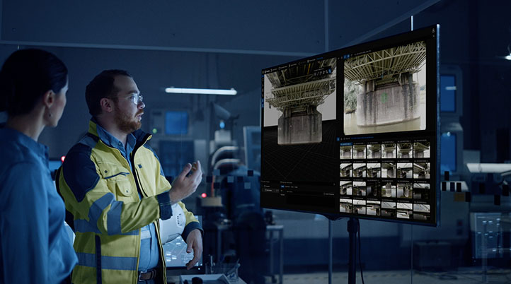
With that in mind, TWINSPECT fully digitizes the drone inspection process by removing the need to manually review collected data and automatically generating photorealistic, true-to-life 3D digital twins for even deeper insights and accurate measurements. By isolating only those images that matter without losing any detail, the software automates damage detection, making it easier to detect issues earlier and reducing the cost of "predictive maintenance." To further help engineers save time and money, TWINSPECT also automatically generates inspection reports based on the user's damage documentation, supplemented with selected inspection images to visually represent the damaged areas.
"Engineering firms and asset owners get an intuitive communication and analysis platform for much more cost-efficient, fast, accurate, and safe damage documentation and inspection of their infrastructure and assets," said Fabien Chalas, CEO at Twinsity.
TWINSPECT makes inspection processes faster and more collaborative as a cloud-based platform, allowing teams to efficiently manage and analyze high-quality drone inspection data directly on a browser, anytime, anywhere. Stakeholders can check buildings regularly in a cost-efficient manner and evaluate the structures in real-time. TWINSPECT also works as the central information hub for drone operators to share data, engineers to perform virtual inspections, and asset owners to get the complete picture of their structures.
"Our platform is like a professional 'Google Earth' for inspections," Chalas added. "We saw the opportunity and necessity to create an interactive and collaborative platform for accessing and analyzing drone data for the inspection teams and asset owners."
Leveraging Machine Learning (ML) algorithms, TWINSPECT's detection and analysis systems' down-to-the-millimeter precision and speed will continuously improve over time.
Netherlands-based GeoZICHT, a company specializing in image and data processing, as well as geographic and geodetic issues, offers a wide range of drone services, from high-quality 3D geospatial data and 360-degree aerial photography to inspection flights of industrial facilities or civil infrastructure. Last year, GeoZICHT used TWINSPECT to collaborate with engineering companies IV-Infra, Westenberg, and Nebest, in a large-scale inspection of more than 20 major bridges belonging to the Dutch authority Rijkswaterstaat.
The company took tens of thousands of inspection photos of each bridge and used TWINSPECT to process them into a 3D model photogrammetrically. With simple mouse clicks on a generated model, the relevant inspection photos were quickly and easily displayed, allowing GeoZICHT to perform fast and more efficient inspections of each bridge. According to GeoZICHT, in addition to reducing risks for manned inspection teams, all inspections were carried out without obstructions or hindrance to waterway traffic under the bridge or traffic on top of them.
"Twinspect from Twinsity proved to be the best platform for digital inspections – as its able to visualize full-resolution digital twins in an interactive 3D environment, with the ability to inspect and measure issues like small deformations on the concrete, directly within the 3D model and the high-resolution inspection images captured by the drone missions," said Jasper Mink, GIS/Photogrammetry Specialist at GeoZICHT.


Comments