Subscribe
The information you submit will be stored and used to communicate with you about your interest in Commercial UAV News. To understand more about how we use and store information, please refer to our privacy policy.

July 11, 2019
DroneDeploy Launches Single Enterprise Solution for All Drone Operations
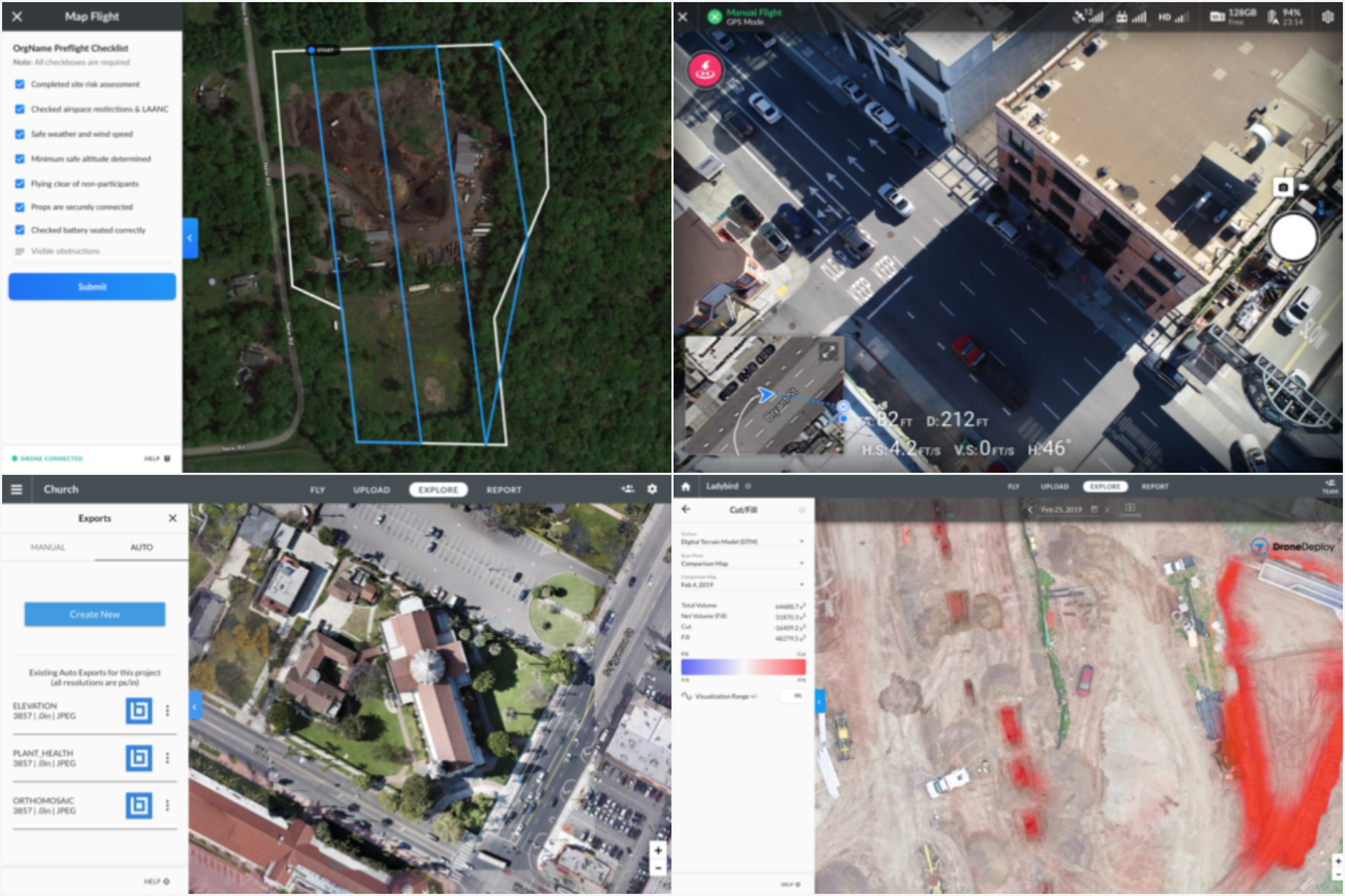
DroneDeploy announced this week a major expansion across its products, making it a single platform for all drone operations. Drone operations management, manual on-site data capture, and greater workflow integrations are just a few of the new cross-product features.According to DroneDeploy, the company now serves over 5,000 customers who have flown 400,000 job sites in more than 180 countries worldwide."[This] product launch is a reflection of the demand from our customers for a complete enterprise-grade drone operating system," said DroneDeploy Chief Executive Officer and co-founder Mike Winn. "We have customers with fleets of 100+ drones looking for a single enterprise platform for their entire drone program, and we believe this launch will reshape how they manage their drone operations and data."The improved suite of capabilities aims to make DronedDeploy a total operations solution for any sized program.New consolidated flight logs allow users to capture all flight information and incidents automatically, for automated and new manual flight modes. The software now includes preflight checklists to ensure operators are following standard operating procedures and pilot and equipment management tool to keep companies in compliance with government and in-house regulations."If you have a growing team of pilots flying on-site or in remote locations, you need to make sure they are following a set of standard operating procedures that encourage safe flight," reads the product release announcement. "Using custom pre-flight checklists you can maximize quality data capture and minimize the risk of drone crashes, property damage, or danger to individuals on each site."A new manual flight mode is now available for low altitude inspection and custom photo and video capture.DroneDeploy’s Earthworks capabilities make it easier for users to accurately measure earthmoving needed to reach finished grade, aiming to keep projects on schedule. DroneDeploy claims to cut down that process down to just a matter of hours when it would have previously taken days or weeks. This feature can be used in construction projects, help mining and aggregates companies plan mines and assist in inventory management.The software expansion also allows users to view, edit, and create annotations in 3D, which includes marker, line, area, and volume measurements, creating a better understanding of changes in inventory or earth that has been moved.With all of the new DroneDeploy capabilities, the most useful might be Auto Exports, a new tool that allows users to sync DroneDeploy with their preferred document storage or project management applications, including Autodesk, Procore, Bluebeam, Plangrid, and OneDrive. The tool eliminates the manual task of digital storage management so users can get back to the project at hand.The DroneDeploy team is hosting a webinar on July 24th through the DroneDeploy Academy to go into more details with customers on the latest expansion.

Want more stories like this? Subscribe today!
.jpg.small.400x400.jpg)

Sam Hill is the News Editor for Commercial UAV News. He previously wrote about the commercial fishing industry as an editor for National Fisherman Magazine and regularly writes about internet culture and entrepreneurship as a freelance journalist.
Featured Report
Featured Authors More Authors ›

Featured Authors


Newsletter Signup
Our Events


Our Events
September 1-3, 2026 • Las Vegas
February 23-25, 2027 • Salt Lake City
Comments