Subscribe
The information you submit will be stored and used to communicate with you about your interest in Commercial UAV News. To understand more about how we use and store information, please refer to our privacy policy.

SPH Engineering Introduces Ground-Penetrating Radar Systems for UAV Integration
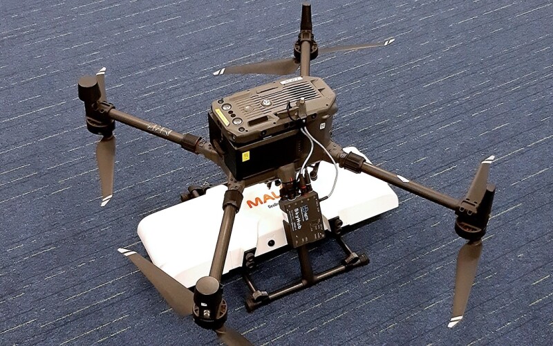
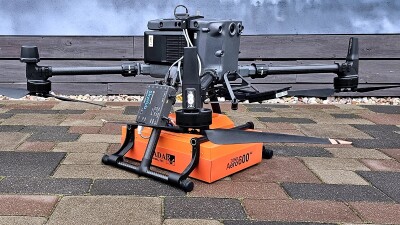
Latvia-based SPH Engineering has introduced two new ground-penetrating radar systems optimized for UAV integration. The company’s MALÅ GeoDrone 600 and Zond Aero 600 NG are 600 MHz antennas that, according to SPH Engineering, “significantly enhance high-resolution subsurface investigations with drones, supporting applications in engineering surveys, utility mapping, archaeology, environmental studies, and geophysical research.”
The products, the company asserted, enable “surveyors to capture consistent, high-quality subsurface data in areas difficult, slow, or unsafe to access with traditional ground instruments.”
Both antennas are compatible with SPH Engineering’s UgCS flight planning software and the SkyHub drone onboard computer. According to the company, these products enable:
- Automated terrain-following flights over complex topography
- Precise altitude control for optimal GPR signal geometry
- Synchronized GNSS + radar trace logging
Commenting on the product launch, Alexey Dobrovolskiy, CEO of SPH Engineering, said, “Adding the MALÅ GeoDrone 600 and the Zond Aero 600 NG to our UAV-GPR portfolio reflects the rapid industry demand for drone-based subsurface mapping. Surveyors, engineers, and researchers can now choose between two high-performance 600 MHz antennas depending on their project requirements. Our goal is to deliver a complete, reliable workflow—from flight automation to secure data logging—that transforms how near-surface geophysics is conducted.”
Source: Press Release

Want more stories like this? Subscribe today!


Commercial UAV News regularly publishes press releases submitted or posted by leading companies and organizations. Please submit any releases for consideration to [email protected].


Newsletter Signup
Our Events


Our Events
September 1-3, 2026 • Las Vegas
February 23-25, 2027 • Salt Lake City
Comments